 EEA geospatial data catalogue
GISCO - Nomenclature of Territorial Units for Statistics 2021 (NUTS 2021), May 2021
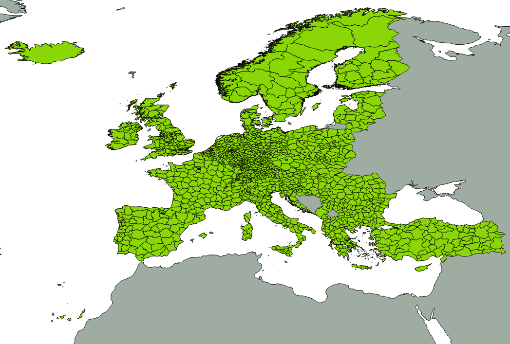
The 'GISCO NUTS 2021' data set represents the NUTS 2021 regulation and statistical regions by means of multipart polygon, polyline and point topology. The NUTS geographical information is completed by attribute tables and a set of cartographic help lines to better visualize multipart polygonal regions.
The NUTS nomenclature is a hierarchical classification of statistical regions defined by Eurostat. The NUTS classification subdivides the EU economic territory into 3 statistical levels. The NUTS 2021 classification has been established through the Commission Delegated Regulation 2019/1755, which entered into force on 8th August 2019 and applies from 1st January 2021. A non official NUTS-like classification has been defined for the EFTA countries and the candidate countries.
At present, six scale ranges (100K, 1M, 3M, 10M and 20M, 60M) are maintained in the GISCO geodatabase. The polygon and boundary classes delineate the regions, while the points provide an anchor for each region. Associated tables contain basic information such as the name of the region. The public data set will be available at 1M, 3M, 10M, 20M, 60M, while the full data set at 100K is restricted.
The data set covers EU Member States, EFTA countries, EU candidate countries and the UK. Following the departure of the UK from the European Union, the UK is no longer flagged as an EU Member State but retains its place in the NUTS and statistical regions data set.
This dataset (NUTS_2021) is derived from the EuroBoundary Map 2020 (EBM2020) from Eurogeographics as well as GISCO NUTS 2016 (from Türkiye). The list of NUTS2021 codes including changes with respect to NUTS2016 is available on https://ec.europa.eu/eurostat/documents/345175/629341/NUTS2021.xlsx. The public metadata for NUTS 2021 released by Eurostat is available here: https://gisco-services.ec.europa.eu/distribution/v2/nuts/nuts-2021-metadata.xml.
This revision (May 2021) includes minor changes in the dataset such as (see https://gisco-services.ec.europa.eu/distribution/v2/nuts/nuts-2021-release-notes.txt):
* 2020-10-05 Point snapping is disabled in all datasets, number of decimals increased for 01M datasets.
* 2020-11-18 Inclusion of Jan Mayen and Svalbard in to Norways Statistical Regions. Amendment to Serbia NUTS BN line status.
* 2020-12-05 Fixed broken utf-8 encoding.
* 2021-03-15 Added LAU 2011,2012,2013,2014,2015,2020
* 2021-04-26 Fixed country labels 2001, 2006 (incorrect Kosovo coordinates)
IMPORTANT NOTE: Additional information, including the conditions of use and acknowledgement notice is included in the document provided with the dataset "GISCO NUTS 2021 Additional Information.pdf". Public access to this data set is restricted due to intellectual property rights. It shall only be used internally by the EEA, its ETCs and subcontractors working on behalf of the EEA. This metadata has been slightly adapted from the original metadata information provided by Eurostat (European Commission) and is to be used only for internal EEA purposes.
An introduction to the NUTS classification is available here: http://ec.europa.eu/eurostat/web/nuts/overview.
Simple
Identification info
- Date (Creation)
- 2020-01-30
- Date (Revision)
- 2021-05-18
- Edition
-
01.01
- Citation identifier
- eurostat_v_4258_100_k_gisco-nuts-2021_i_2021_v01_r01
- Citation identifier
- DAT-291-en
- Spatial representation type
- Vector
Spatial resolution
Equivalent scale
- Denominator
- 100000
Spatial resolution
Equivalent scale
- Denominator
- 1000000
Spatial resolution
Equivalent scale
- Denominator
- 3000000
Spatial resolution
Equivalent scale
- Denominator
- 10000000
Spatial resolution
Equivalent scale
- Denominator
- 20000000
Spatial resolution
Equivalent scale
- Denominator
- 60000000
- Topic category
-
- Boundaries
Extent
))
Temporal extent
- Time period
- 2020-01-01
- Maintenance and update frequency
- As needed
- Continents, countries, sea regions of the world.
-
-
Italy
-
Liechtenstein
-
Bulgaria
-
Albania
-
Poland
-
Luxembourg
-
Belgium
-
Türkiye
-
Lithuania
-
Sweden
-
Switzerland
-
Malta
-
France
-
Iceland
-
Romania
-
Hungary
-
Ireland
-
Netherlands
-
Latvia
-
Montenegro
-
Croatia
-
Spain
-
Czechia
-
North Macedonia
-
Slovakia
-
Estonia
-
Denmark
-
Norway
-
Portugal
-
Greece
-
Serbia
-
Germany
-
Slovenia
-
Finland
-
United Kingdom
-
Austria
-
Cyprus
-
Resource constraints
- Access constraints
- Other restrictions
Resource constraints
- Use constraints
- Other restrictions
- Other constraints
-
Access to this data set is restricted to the personnel of the European Commission and its contractors. Contractors of the European Commission, its Executive Agencies and EEA can access the data after signing an agreement form. The agreement form can be requested by the responsible service from European Commission – Eurostat/GISCO ESTAT-GISCO@ec.europa.eu. Once the form has been signed, access will be provided by European Commission - Eurostat/GISCO.
Public access to the full data set is not possible due to intellectual property rights. Use is allowed inside the European Commission. However, the data set can be freely distributed if the spatial resolution is 1:1.000.000 or smaller, or less than 20% of the data relevant to the displayed area is shown.The source and intellectual property have always to be acknowledged. To this end, an acknowledgement as specified below must be visible on any printed or electronic publication using the data. In English, the acknowledgement notice is "Administrative boundaries: © EuroGeographics, © FAO (UN), © TurkStat. Source: European Commission – Eurostat/GISCO". More information in the document "GISCO NUTS 2021 Additional Information.pdf" provided with the dataset.
Associated resource
- Association Type
- Revision Of
- Language
- English
- Character encoding
- UTF8
Distribution Information
- Distribution format
-
-
Geopackage
-
- OnLine resource
-
Direct download (Eionet authentication)
Data quality info
- Hierarchy level
- Dataset
Report
Result
- Title
- Commission Regulation (EU) No 1089/2010 of 23 November 2010 implementing Directive 2007/2/EC of the European Parliament and of the Council as regards interoperability of spatial data sets and services
- Date (Publication)
- 2010-12-08
- Explanation
-
See the referenced specification
Resource lineage
- Statement
-
NUTS 2021 dataset is based on: EuroBoundaryMap (EBM) v2020 from EuroGeographics (scale of 1:100.000), Global Administrative Unit Layer (GAUL) 2015 country data from UN/FAO, data from the National Statistical Institute of Türkiye (TurkStat).
The different scale levels were derived by generalisation of the 100K scale. This dataset consists of 2 feature classes (region polygons and boundaries) per scale level (100k, 1M, 3M, 10M, 20M, 60M). In addition, there is also a label feature class (scale independent). This labelpoint feature class was created with a label inside each NUTS region at the 3 NUTS levels (1 - 3) and countries. Furthermore, two line feature classes were created: one feature class for cartographic joiners to identify where NUTS areas have one or more enclaves and a second line feature class, for cartographic separators to identify where the NUTS limits are in the sea. The arcs of the two latter feature classes are only useful for cartographic purposes and are not meant to identify actual administrative or statistical boundaries stretching into the sea or have any other significance. The boundaries and regions are related to each other through a relationship table. Associated tables contain basic information such as the region's name. The 5 small scale feature classes should be used exclusively for cartographic purposes. This dataset is consistent at all scales with the following datasets: Communes and LAUS 2019 of European Commission, Eurostat/GISCO, Countries 2020, European Commission - Eurostat/GISCO, Coastlines 2020, European Commission - Eurostat/GISCO. Exclusive Economic Zones 2020, European Commission - Eurostat/GISCO. Different tests were performed to ensure conceptual-, domain- and topological- consistency
For more information about the data sources, the data model and attributes, data quality checks and relations with other GISCO data sets please refer to the document provided with the dataset "GISCO NUTS 2021 Additional Information.pdf".
This revision (May 2021) includes minor changes in the dataset such as (see https://gisco-services.ec.europa.eu/distribution/v2/nuts/nuts-2021-release-notes.txt):
* 2020-10-05 Point snapping is disabled in all datasets, number of decimals increased for 01M datasets.
* 2020-11-18 Inclusion of Jan Mayen and Svalbard in to Norways Statistical Regions. Amendment to Serbia NUTS BN line status.
* 2020-12-05 Fixed broken utf-8 encoding.
* 2021-03-15 Added LAU 2011,2012,2013,2014,2015,2020
* 2021-04-26 Fixed country labels 2001, 2006 (incorrect Kosovo coordinates)
- Hierarchy level
- Dataset
Reference System Information
Reference System Information
- Code
- EPSG:4258
Metadata
- Metadata identifier
- e4316fd1-db00-428b-8034-61d56c2fe2ca
- Language
- English
Type of resource
- Resource type
- Dataset
- Name
-
Service
- Date info (Creation)
- 2021-06-04T08:17:41.842Z
- Date info (Revision)
- 2026-03-30T13:02:45.03189Z
Metadata standard
- Title
-
INSPIRE Metadata Commission Regulation (EC) No 1205/2008
- Edition
-
03.12.2008
)))