 EEA geospatial data catalogue
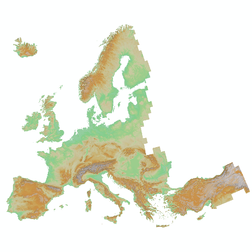
EU-DEM (raster) - version 1.0, Apr. 2016
EU-DEM v1.0 is a digital surface model (DSM) representing the first surface as illuminated by the sensors. It is a hybrid product based on SRTM and ASTER GDEM data fused by a weighted averaging approach and generated as a contiguous dataset divided into 1 degree by 1 degree tiles, corresponding to the SRTM naming convention. The spatial reference system is geographic, lat/lon with horizontal datum ETRS89, ellipsoid GRS80 and vertical datum EVRS2000 with geoid EGG08. These tiles have then been aggregated into 5°x5° tiles which have been projected to ETRS-LAEA by the Joint Research Centre (JRC) of the European Commission.
The implementation of EU-DEM v1.0 was coordinated by the European Commission in 2009-2011 in the framework of the Reference Data Access (RDA) Action of the EU GMES/Copernicus programme.
Simple
Identification info
- Date (Creation)
- 2016-04-20
- Date (Publication)
- 2016-04-20
- Date (Revision)
- 2016-04-20
- Edition
-
01.00
- Citation identifier
- copernicus_r_3035_25_m_eu-dem_p_2000_v01_r00
- Citation identifier
- DAT-193-en
- Status
- Obsolete
- Point of contact
-
Organisation Individual Electronic mail address Website Role European Environment Agency
European Commission
Owner Copernicus Land Monitoring Service
Custodian European Environment Agency
Publisher Copernicus Land Monitoring Service helpdesk
Point of contact
- Spatial representation type
- Grid
Spatial resolution
- Spatial resolution
- 25 m
- Topic category
-
- Environment
- Imagery base maps earth cover
Extent
Temporal extent
- Time period
- 2000-01-01 2000-12-31
Extent
))
))
- Maintenance and update frequency
- Continual
- Keywords
-
-
geospatial data
-
Resource constraints
- Access constraints
- Other restrictions
- Other constraints
- no limitations to public access
Resource constraints
- Use constraints
- Other restrictions
- Other constraints
-
The Copernicus component is governed by Regulation (EU) No 2021/696 of the European Parliament and of the Council of 28 April 2021 establishing the Union Space Programme and the European Union Agency for the Space Programme and repealing Regulations (EU) No 912/2010, (EU) No 1285/2013 and (EU) No 377/2014 and Decision No 541/2014/EU. Within the Copernicus component, a portfolio of land monitoring activities has been delegated by the European Union to the European Environment Agency (EEA) and the DG Joint Research Centre of the European Commission.
The Copernicus land monitoring products and services are made available on a principle of full, open and free access, as established by the Commission Delegated Regulation (EU) No 1159/2013 of 12 July 2013.
Free, full and open access to the products and services of the Copernicus Land Monitoring Service is made on the conditions that:
1. When distributing or communicating Copernicus Land Monitoring Service products and services (data, software scripts, web services, user and methodological documentation and similar) to the public, users shall inform the public of the source of these products and services.
2. Where the Copernicus Land Monitoring Service products and services have been adapted or modified by the user, the user shall clearly state this.
3. Users shall make sure not to convey the impression to the public that the user's activities are officially endorsed by the European Union.
- Language
- English
- Character encoding
- UTF8
Distribution Information
- Distribution format
-
-
GeoTIFF
-
- Distributor contact
-
Organisation Individual Electronic mail address Website Role
- Ordering instructions
-
EU-DEM is not maintained anymore by the Copernicus Land Monitoring Service.
Copernicus DEM product publicly available at 30 m and 90 m spatial resolution can be accessed on the Copernicus Data Space Ecosystem (CDSE). More information can be found here: https://dataspace.copernicus.eu/explore-data/data-collections/copernicus-contributing-missions/collections-description/COP-DEM
If you have further questions please contact the CLMS helpdesk at JRC-Copernicus-Land@ec.europa.eu
Data quality info
- Hierarchy level
- Dataset
Report
Result
- Date (Publication)
- Explanation
-
See the referenced specification
Resource lineage
- Statement
-
The EU-DEM v1.0 is derived from an automated data fusion process using SRTM and ASTER GDEM digital surface model (DSM) data. Intermap's NEXTMap Europe dataset is utilized to remove any consistent horizontal bias in the GDEM data. The EU-DEM v1.0 is edited to ensure that water features are adequately represented and consistent with the hydrography layer. Residual clouds within the GDEM data are identified and removed same as suspect data extremely differing from the SRTM data. All EU-DEM tiles are edited interactively in a 3D stereo environment. The editing is restricted to the hydrographical features and pits and bumps. In areas above 60 degrees North, the EU-DEM generation process is supported by other DEM data sources provided by the JRC. Water features are flattened (oceans, lakes) and stepped (rivers) based on the hydrography data. The spatial reference system is geographic, lat/lon with horizontal datum ETRS89, ellipsoid GRS80 and vertical datum EVRS2000 with geoid EGG08.
- Hierarchy level
- Dataset
Reference System Information
Reference System Information
- Code
- EPSG:3035
- Maintenance and update frequency
Metadata
- Metadata identifier
- 19cff95e-61ac-45ed-8ee3-c43220d709cf
- Language
- English
- Character encoding
- UTF8
- Contact
-
Organisation Individual Electronic mail address Website Role European Environment Agency
Point of contact
Type of resource
- Resource type
- Dataset
- Metadata linkage
-
https://sdi.eea.europa.eu/catalogue/srv/api/records/19cff95e-61ac-45ed-8ee3-c43220d709cf
- Date info (Creation)
- 2018-01-22T09:02:36Z
- Date info (Revision)
- 2025-10-09T10:38:48.14227Z
Metadata standard
- Title
-
ISO 19115/19139
- Edition
-
1.0
),POLYGON((44.8212%2034.5619,44.8212%2071.1855,-10.6198%2071.1855,-10.6198%2034.5619,44.8212%2034.5619))))