 EEA geospatial data catalogue
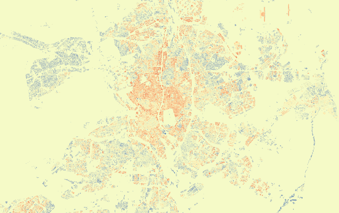
Urban Atlas - Building Height 2012, version 2 (raster), Mar. 2020
The Copernicus Urban Atlas - Building Height 2012 product is a 10m high resolution raster layer containing height information generated for core urban areas of selected cities (capitals) in EEA38 (with the exception of Vaduz, Liechtenstein) and the United Kingdom as part of the Urban Atlas, with reference year 2012.
The height information is based on IRS-P5 stereo images and derived datasets like the digital surface model, the digital terrain model and the normalized DSM.
This metadata refers an update of this product, which includes the extension of previously published cities Amsterdam, Athens, Berlin, Copenhagen, London and Madrid (version 2.0) and capitals from countries not included in the previous version (Türkiye and EEA cooperating countries). The other core cities in the dataset remain unaltered (version 1.0), but may be updated in the near future.
There is one zip archive per area, which includes: (1) the actual raster data in GeoTIFF format (ETRS89-LAEA); (2) an XML-file with metadata and (3) document with results of quality checks.
Simple
Identification info
- Date (Creation)
- 2018-04-19
- Date (Publication)
- 2018-04-19
- Date (Revision)
- 2020-03-19
- Edition
-
02.00
- Citation identifier
- copernicus_r_3035_10_m_ua-bh-2012_p_2011-2014_v02_r00
- Citation identifier
- DAT-190-en
- Status
- Superseded
- Spatial representation type
- Grid
Spatial resolution
- Spatial resolution
- 10 m
- Topic category
-
- Environment
- Imagery base maps earth cover
- Elevation
Extent
Temporal extent
- Time period
- 2011-01-01 2014-12-31
Extent
))
- Maintenance and update frequency
- Continual
- Continents, countries, sea regions of the world.
-
-
Switzerland
-
United Kingdom
-
Albania
-
Norway
-
Serbia
-
Bosnia and Herzegovina
-
Türkiye
-
EU27 (from 2020)
-
Iceland
-
North Macedonia
-
Kosovo (UNSCR 1244/99)
-
Montenegro
-
- EEA Management Plan
-
-
2018 3.6.2
-
Resource constraints
- Access constraints
- Other restrictions
- Other constraints
- no limitations to public access
Resource constraints
- Use constraints
- Other restrictions
- Other constraints
-
The Copernicus component is governed by Regulation (EU) No 2021/696 of the European Parliament and of the Council of 28 April 2021 establishing the Union Space Programme and the European Union Agency for the Space Programme and repealing Regulations (EU) No 912/2010, (EU) No 1285/2013 and (EU) No 377/2014 and Decision No 541/2014/EU. Within the Copernicus component, a portfolio of land monitoring activities has been delegated by the European Union to the European Environment Agency (EEA) and the DG Joint Research Centre of the European Commission.
The Copernicus land monitoring products and services are made available on a principle of full, open and free access, as established by the Commission Delegated Regulation (EU) No 1159/2013 of 12 July 2013.
Free, full and open access to the products and services of the Copernicus Land Monitoring Service is made on the conditions that:
1. When distributing or communicating Copernicus Land Monitoring Service products and services (data, software scripts, web services, user and methodological documentation and similar) to the public, users shall inform the public of the source of these products and services.
2. Where the Copernicus Land Monitoring Service products and services have been adapted or modified by the user, the user shall clearly state this.
3. Users shall make sure not to convey the impression to the public that the user's activities are officially endorsed by the European Union.
Associated resource
- Association Type
- Revision Of
- Metadata Reference
- Language
- English
- Character encoding
- UTF8
- Additional Information
-
Spatial Resolution information: The Minimum Mapping Width is 10 m
Distribution Information
- Distribution format
-
-
GeoTIFF
-
- OnLine resource
-
Download (requires authentication)
Data quality info
- Hierarchy level
- Dataset
Report
Result
- Title
- Commission Regulation (EU) No 1089/2010 of 23 November 2010 implementing Directive 2007/2/EC of the European Parliament and of the Council as regards interoperability of spatial data sets and services
- Date (Publication)
- 2010-12-08
- Explanation
-
See the referenced specification
Resource lineage
- Statement
-
This product is generated based on IRS-P5 stereo images acquired as close as possible to the defined reference year. Based on these stereo images a digital surface model is generated. Afterwards a digital terrain model is derived from the DSM with different filter algorithms and the assistance of Urban Atlas 2012 datasets. The calculation of the normalized DSM is done by a simple subtraction of the DTM from the DSM. The final product is then clipped based on UA 2012 building blocks and fully quality controlled.
This update marks the extension of previously published cities Amsterdam, Athens, Berlin, Copenhagen, London and Madrid (version 2.0). Capitals from countries not included in the previous version (Türkiye and EEA cooperating countries) have also been added. The rest of the core cities (capitals) remain altered (version 1.0).
Information about the validation of this product is available here: https://land.copernicus.eu/user-corner/technical-library/building-heights-2012-validation-report
- Hierarchy level
- Dataset
Reference System Information
Reference System Information
- Code
- EPSG:3035
- Maintenance and update frequency
Metadata
- Metadata identifier
- 55854f4a-19b7-49f3-abd3-4f974a683d6f
- Language
- English
- Character encoding
- UTF8
- Contact
-
Organisation Individual Electronic mail address Website Role European Environment Agency
Point of contact
Type of resource
- Resource type
- Dataset
- Metadata linkage
-
https://sdi.eea.europa.eu/catalogue/srv/api/records/55854f4a-19b7-49f3-abd3-4f974a683d6f
- Date info (Creation)
- 2021-07-30T09:40:52.126Z
- Date info (Revision)
- 2026-02-20T10:02:28.041797Z
Metadata standard
- Title
-
ISO 19115/19139
- Edition
-
1.0
)))