 EEA geospatial data catalogue
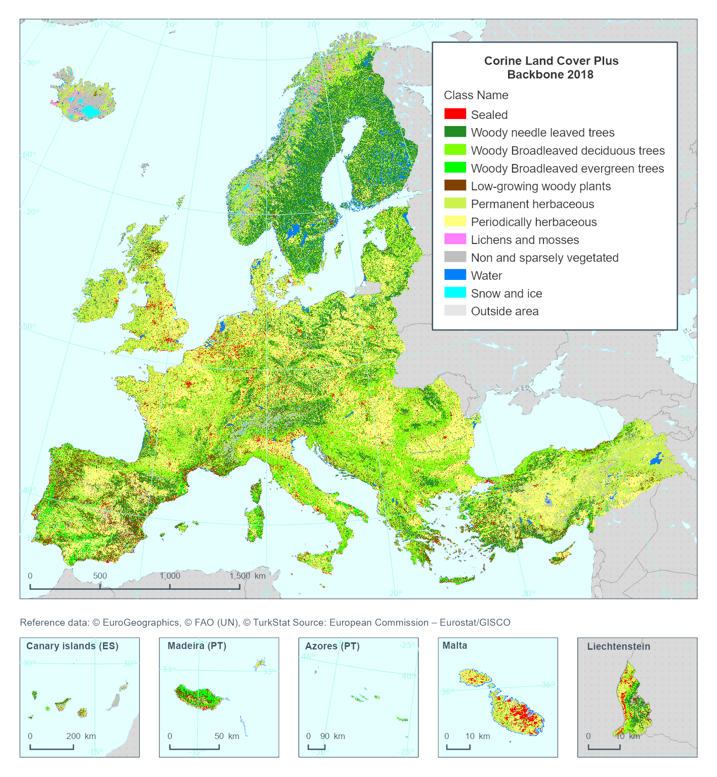
CLCplus Backbone 2018 (raster 10 m), Europe, 3-yearly, Feb. 2023
This metadata refer to the 'Corine Land Cover plus Backbone' (CLCplus Backbone) which is a spatially detailed, large scale, Earth Observation-based land cover inventory. The CLCplus Backbone Raster Product is a 10m pixel-based land cover map based on Sentinel satellite time series from July 2017 to June 2019. For each pixel it shows the dominant land cover among the 11 basic land cover classes.
The product has a three years update cycle and is available for the 2018 reference year.
Simple
Identification info
-
Date (Creation)
- 2022-03-07
-
Date (Publication)
- 2023-01-23
-
Edition
-
01.1
-
Citation identifier
- copernicus_r_3035_10_m_chaplus-backbone2017-2019_p_2018_v01_r1
Identifier
- Point of contact
-
Organisation Individual Electronic mail address Website Role European Commission
OwnerCopernicus Land Monitoring Service
CustodianEuropean Environment Agency
PublisherCopernicus Land Monitoring Service helpdesk
Point of contact
-
Spatial representation type
-
Grid
Spatial resolution
-
Spatial resolution
- 10 m
-
Topic category
-
-
Environment
-
Imagery base maps earth cover
-
Extent
))
Temporal extent
-
Time period
- 2017-07-01 2019-06-30
-
Maintenance and update frequency
-
As needed
- GEMET - INSPIRE themes, version 1.0
-
-
Land cover
-
- Continents, countries, sea regions of the world.
-
-
United Kingdom
-
EEA38 (from 2020)
-
- GEMET
-
-
land cover
-
land
-
- EEA topics
-
-
Land use
-
Resource constraints
-
Access constraints
-
Other restrictions
-
Other constraints
- no limitations to public access
Resource constraints
-
Use constraints
-
Other restrictions
-
Other constraints
-
The Copernicus component is governed by Regulation (EU) No 2021/696 of the European Parliament and of the Council of 28 April 2021 establishing the Union Space Programme and the European Union Agency for the Space Programme and repealing Regulations (EU) No 912/2010, (EU) No 1285/2013 and (EU) No 377/2014 and Decision No 541/2014/EU. Within the Copernicus component, a portfolio of land monitoring activities has been delegated by the European Union to the European Environment Agency (EEA) and the DG Joint Research Centre of the European Commission.
The Copernicus land monitoring products and services are made available on a principle of full, open and free access, as established by the Commission Delegated Regulation (EU) No 1159/2013 of 12 July 2013.
Free, full and open access to the products and services of the Copernicus Land Monitoring Service is made on the conditions that:
1. When distributing or communicating Copernicus Land Monitoring Service products and services (data, software scripts, web services, user and methodological documentation and similar) to the public, users shall inform the public of the source of these products and services.
2. Where the Copernicus Land Monitoring Service products and services have been adapted or modified by the user, the user shall clearly state this.
3. Users shall make sure not to convey the impression to the public that the user's activities are officially endorsed by the European Union.
-
Language
- English
-
Character encoding
-
UTF8
-
Additional Information
-
Thematic pixel values:
1: Sealed
2: Woody – needle leaved trees
3: Woody – Broadleaved deciduous trees
4: Woody – Broadleaved evergreen trees
5: Low-growing woody plants (bushes, shrubs)
6: Permanent herbaceous
7: Periodically herbaceous
8: Lichens and mosses
9: Non- and sparsely-vegetated
10: Water
11: Snow and ice
254: outside area
255: No data
Distribution Information
-
Distribution format
-
-
GeoTIFF
-
-
OnLine resource
-
CLMS Website
Download (requires authentication)
-
OnLine resource
-
Product Information & Technical Documentation
-
OnLine resource
-
0
CLMS_CLCplus_RASTER_2018_010m_eu
Data quality info
-
Hierarchy level
-
Dataset
Report
Result
-
Title
- Commission Regulation (EU) No 1089/2010 of 23 November 2010 implementing Directive 2007/2/EC of the European Parliament and of the Council as regards interoperability of spatial data sets and services
-
Date (Publication)
- 2010-12-08
-
Explanation
-
See the referenced specification
Resource lineage
-
Statement
-
The CLCplus Backbone Raster Product is primarily based on a supervised classification of satellite image time-series from Sentinel-2 L2A including all scenes with a cloud cover below 80% and acquired from July 2017 and June 2019. The time series is initially resampled in along the time axis to obtain an equidistant time-series at 10-day intervals. Clouds and cloud shadows are masked out before based on masks produced with FMask 4.1.
Training and test data were compiled for the reference year 2018 from various sources, such as from adjusted and filtered LUCAS 2018 survey point data; stratified automated LC class annotations based on existing land use/land cover maps, as well as from additional visual sample point photointerpretation relying on VHR imagery, NDVI time series and auxiliary datasets.
A temporal Convolutional Neural Network with four hierarchical layers was calibrated on the collected training data and input time-series / features. Given the heterogeneity of the addressed European landscapes, all classifier training, testing and, finally, LC classification, is performed along substrata based on biogeographical regions and existing LC layers.
Dedicated post-processing steps include bilateral filtering to reduce labelling noise, as well as adjustments of the class probabilities and threshold based on auxiliary data such as street networks, national and regional land cover and land use maps or existing Pan-European land cover maps.
Quality assurance follows the ISO 9001:2015 standards for Quality Management and comprises of dedicated procedures of quality checks (QA breakpoints) during implementation of the production chain, in order to keep persistent control over the various stages of production, assure fitness-for-purpose of the end-products and that all quality requirements are fulfilled. Priority has been given to the target thematic accuracy to be achieved by each product, as well as to the issues of product consistency (spatial, thematic, temporal) and homogeneity.
Quality Assessment: The quality assessment has been performed according to INSPIRE Data Specifications. The data quality elements considered are: (i) Completeness, (ii) Logical Consistency, (iii) positional accuracy, (iv) Thematic Accuracy, (v) Temporal quality and (vi) Usability.
Geometric accuracy (positioning scale): Equals Sentinel-2 positional accuracy in 2018 (~11m at 95.5% confidence).
Thematic target accuracy: An independent internal accuracy assessment based on the interpretation of more than 42,000 samples (plausibility analysis) assessed the overall accuracy for the EU27 area at 92.8% (+-0.3%) and for the full EEA38+UK coverage at 91.9% (+/-0.3%). The targeted producer's and user's accuracies are above the target of at least 85% for all classes except for Low-growing woody plants, Lichens and Mosses, and Non-and sparsely vegetated which are subject to regionally lower accuracies. Further details on the internal validation results are presented in the Product User Manual.
-
Hierarchy level
-
Dataset
Reference System Information
Reference System Information
-
Code
- EPSG:3035
-
Maintenance and update frequency
Metadata
-
Metadata identifier
- cd534ebf-f553-42f0-9ac1-62c1dc36d32c
-
Language
- English
-
Character encoding
-
UTF8
- Contact
-
Organisation Individual Electronic mail address Website Role European Environment Agency
Point of contact
Type of resource
-
Resource type
-
Dataset
-
Metadata linkage
-
https://sdi.eea.europa.eu/catalogue/srv/api/records/cd534ebf-f553-42f0-9ac1-62c1dc36d32c
-
Date info (Creation)
- 2022-11-14T10:25:39.999Z
-
Date info (Revision)
- 2025-10-09T11:15:24.877326Z
Metadata standard
-
Title
-
ISO 19115/19139
-
Edition
-
1.0
)))