 EEA geospatial data catalogue
Common Database on Designated Areas (CDDA) version 8 - vector and tabular data for public access, Jun. 2009
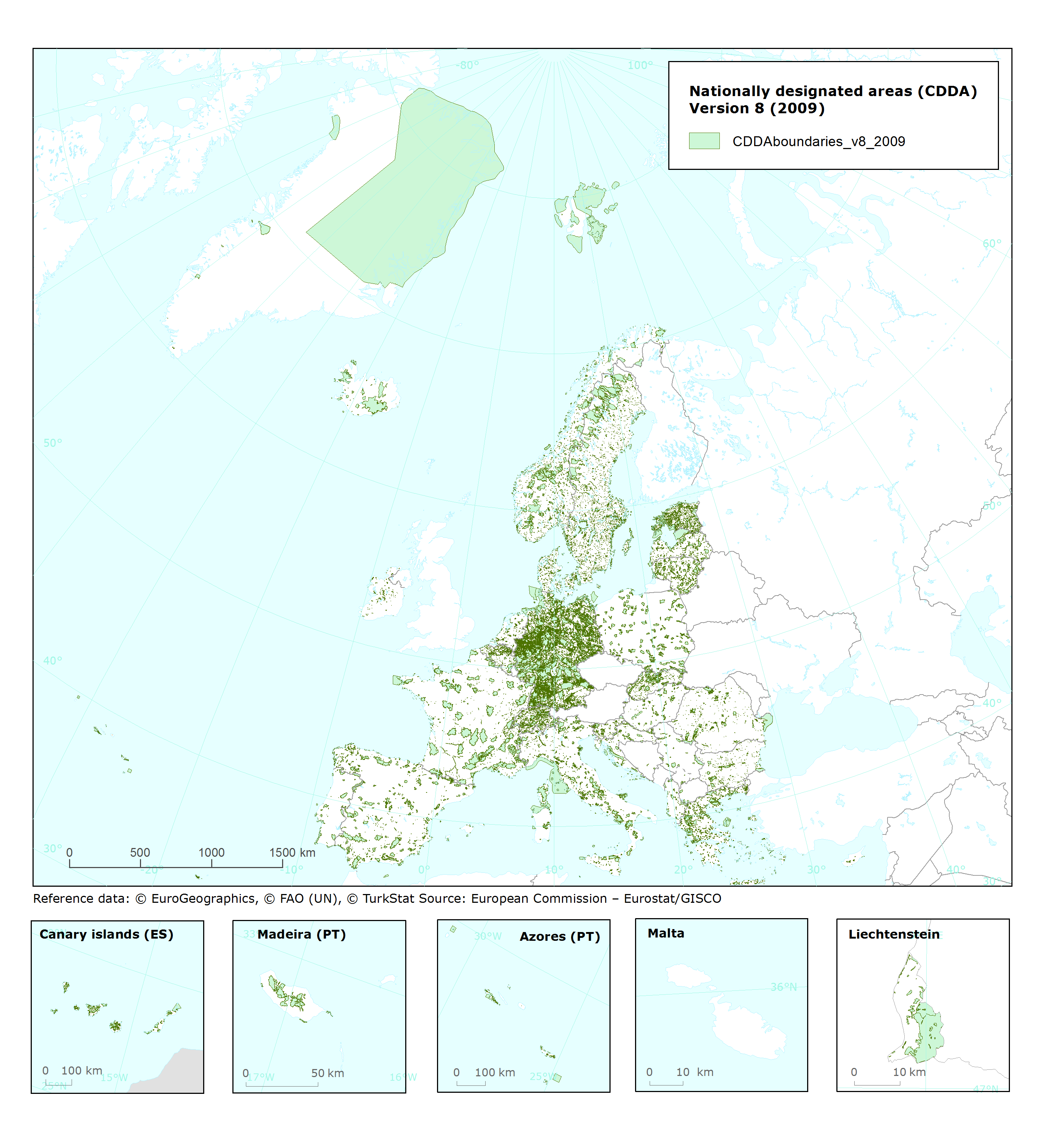
This metadata refer to the European inventory of nationally designated areas holding information about protected sites and about the national legislative instruments, which directly or indirectly create protected areas. This is the version 8 for public access.
Simple
Identification info
- Date (Creation)
- 2009-06-01
- Date (Publication)
- 2009-09-30
- Edition
-
08.00
- Citation identifier
- eea_v_3035_100_k_cdda-poly_p_2009_v08_r00
- Status
- Superseded
- Point of contact
-
Organisation Individual Electronic mail address Website Role European Environment Agency
Point of contact European Environment Agency
Custodian
- Spatial representation type
- Vector
Spatial resolution
- Spatial resolution
- 100 m
- Topic category
-
- Environment
- Geoscientific information
Extent
))
Extent
Temporal extent
- Time period
- 2009-01-01 2009-12-31
- Maintenance and update frequency
- Annually
- GEMET - INSPIRE themes, version 1.0
-
-
Protected sites
-
- EEA topics
Resource constraints
- Access constraints
- Other restrictions
- Other constraints
- no limitations to public access
Resource constraints
- Use constraints
- Other restrictions
- Other constraints
-
License CC-BY 4.0 ( https://creativecommons.org/licenses/by/4.0/). Copyright holder: European Environment Agency (EEA).
- Language
- English
- Character encoding
- UTF8
- Additional Information
-
The inventory began under the CORINE programme. It is now maintained for EEA by the European Topic Centre on Biological Diversity and is annually updated through Eionet. EEA provides the European inventory of nationally designated areas to the World Database of Protected Areas (WDPA) and to Eurostat. The nationally designated areas data can also be queried online in the European Nature Information System (EUNIS). The inventory is the national module of the Common Database on Designated Areas (CDDA) which also includes information on areas designated under European Community legislation and areas designated under international conventions. A poster describing the CDDA is available at: http://biodiversity-chm.eea.europa.eu/information/document/EEA/1082987029.
Release note for version 8: 34 countries updated their information on legislative instruments, sites and site boundaries in the 2009 Eionet data collection. Information for European countries outside Eionet has been included from the 2009 version of WDPA. A quality report on version 8 is available, in particular on the quality of data from the Eionet countries. There has been a revision of the data format with the removal of items which it was agreed have little value at the European level. For the first time Eionet countries were asked to report in 2009 on their total protected area (terrestrial and marine). This is a step towards improving comparability between aggregated information published at national and European level and it is expected that the values made available for some countries will be revised in future releases of the data set.
This information is from the European Common Database on Designated Areas established and managed collaboratively by the European Environment Agency, the UNEP-World Conservation Monitoring Centre and the Council of Europe, based on data provided by national sources
Geographical coverage GIS vector boundary data: Belgium, Bosnia and Herzegovina, Bulgaria, Croatia, Cyprus, Czech Republic, Denmark, Estonia, France, Germany, Hungary, Iceland, Italy, Latvia, Liechtenstein, Lithuania, Malta, Netherlands, Norway, Portugal, Romania, Serbia, Slovakia, Slovenia, Spain, Sweden, Switzerland, Turkey. EEA does not have permission to distribute some or all sites reported by Austria, Estonia, Finland, Great Britain, Greece and the Netherlands. Copyright has to be mentioned for Estonia, Germany and Slovenia.
Distribution Information
- Distribution format
-
-
SHP
-
ascii (.csv, .txt, .sql)
-
Microsoft Excel (.xls, .xlsx)
-
- OnLine resource
-
https://sdi.eea.europa.eu/webdav/datastore/public/eea_v_3035_100_k_cdda-poly_p_2009_v08_r00
- OnLine resource
-
Direct download
- OnLine resource
-
QA Documentation
- OnLine resource
-
GIS data documentation
- OnLine resource
-
Look-up tables (text/comma-separated-values)
Data quality info
- Hierarchy level
- Dataset
Report
Result
- Title
-
Commission Regulation (EU) No 1089/2010 of 23 November 2010 implementing Directive 2007/2/EC of the European Parliament and of the Council as regards interoperability of spatial data sets and services
- Date (Publication)
- 2010-12-08
- Explanation
-
See the referenced specification
Resource lineage
- Statement
-
This dataset was built from the original CDDA vector. The raster grid is aligned with the EEA reference grid GeoTIFFs generated by GRASS, according to the GeoTIFF Revision 1.0 specifications at https://www.ogc.org/publications/standard/geotiff/. The information displays if there is or not CDDA sites under each specific pixel zones .
process steps
Description:
==========
Rasterisation
Resource name:
CDDA_2009_polygon_Merge.shp
Resource date:
20091021
Accessible data
============
CDDA - Microsoft Access database (5 tables)
Database contains all data tables. Detailed table definitions are displayed in the section with individual tables.
List of designations by country:
CDDA_v8_designations in csv- and excel formats
Table contains list of designations, references to laws as well as number and total area of sites per designation.
List of designation boundaries by country:
CDDA_v8_designated_boundaries in csv- and excel formats
Table contains list of digital boundaries of protected areas not defined as sites. Provides information on resolution of source material from which the boundary has been derived. Instructs EEA regarding dissemination of boundaries.
Sites data table:
Ascii format
Table contains main information (name, location, area, IUCN category etc) of each individual designated area at national level.
CDDA boundaries 2009:
CDDA boundaries 2009, vector shape file format
Look-up tables contains all code lists used in the data tables
Country codes and abbreviations (63 records) contains a list of ISO Alpha 3 codes used in CDDA_designations and CDDA_sites tables. Complete and actual list can be found at the following URL: http://unstats.un.org/unsd/methods/m49/m49alpha.htm#ftna (Source: United Nations Statistics Division).
Tables metadata contains metadata definitions of all data tables
CDDA - QA/QC documents
Quality asssesment and control reports present results of quality tests performed by the EEA and the ETC-BD on top of the national CDDA data. The ETC-BD assesment is more focused on geographical data and on their relation with tabular data.
- Hierarchy level
- Dataset
Reference System Information
Reference System Information
- Code
- EPSG:3035
Metadata
- Metadata identifier
- 093fec8c-2ff8-4b29-80ed-a3cef8de94ad
- Language
- English
- Character encoding
- UTF8
- Contact
-
Organisation Individual Electronic mail address Website Role European Environment Agency
Point of contact
Type of resource
- Resource type
- Dataset
- Date info (Creation)
- 2023-03-30T08:23:23.659Z
- Date info (Revision)
- 2025-10-09T10:35:38.788116Z
Metadata standard
- Title
-
ISO 19115/19139
- Edition
-
1.0
)))