 EEA geospatial data catalogue
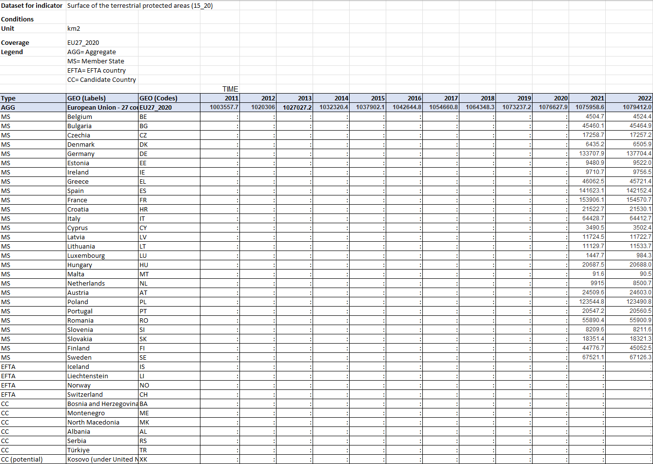
Surface of the terrestrial protected areas (2011-2022)
This indicator measures the extent and share of terrestrial protected areas. The indicator comprises nationally designated protected areas and Natura 2000 sites. A nationally designated area is an area protected by national legislation. Natura 2000 network sites consists of sites designated under the EU Habitats and Birds Directives with the goal to maintain or restore a favourable conservation status for habitat types and species of EU interest.
Simple
Identification info
- Date (Creation)
- 2024-11-14
- Date (Publication)
- 2024-11-14
- Date (Revision)
- 2025-05-26
- Edition
-
01.00
- Citation identifier
- eea_s_eu-sdg-15-20_p_2011-2022_v01_r00
Identifier
- Status
- Superseded
- Point of contact
-
Organisation Individual Electronic mail address Website Role European Environment Agency
Point of contact
- Topic category
-
- Environment
Extent
Temporal extent
- Time period
- 2011-01-01 2022-12-31
- Maintenance and update frequency
- Annually
- Date
- 2025-11
- Date type
- Next Update
- Continents, countries, sea regions of the world.
-
-
EU27 (from 2020)
-
- EEA Management Plan
-
-
2024 1.1.16
-
- Available breakdowns
-
-
Country
-
- Unit of measure
-
-
Percentage
-
Square kilometre
-
- Reference period
-
-
Calendar year
-
Resource constraints
- Use constraints
- Other restrictions
- Other constraints
-
License CC-BY 4.0 ( https://creativecommons.org/licenses/by/4.0/). Copyright holder: European Environment Agency (EEA).
- Language
- English
Distribution Information
- Distribution format
-
-
Microsoft Excel (.xls, .xlsx)
-
ascii (.csv, .txt, .sql)
-
- OnLine resource
-
https://sdi.eea.europa.eu/webdav/datastore/public/eea_s_eu-sdg-15-20_p_2011-2022_v01_r00
- OnLine resource
-
Direct download
- OnLine resource
-
EEA Indicator: Terrestrial protected areas in Europe
- OnLine resource
-
Eurostat indicator: Surface of the terrestrial protected areas
Data quality info
- Hierarchy level
- Dataset
Report
- Name of measure
-
Frequency of dissemination
- Measure description
-
Indicator is updated annually.
Result
- Value
- Every year
Report
- Name of measure
-
Timeliness
- Measure description
-
New data points are disseminated within two years after the reference year.
Result
- Value
- T+2 years
Report
- Name of measure
-
Reference area
- Measure description
-
Data are presented for all EU Member States for 2021. Before 2020 only EU27 aggregate.
Result
- Value
- All EU MS
Report
- Name of measure
-
Comparability - geographical
- Measure description
-
Data are comparable between all EU Member States.
Result
- Value
- All EU MS
Report
- Name of measure
-
Time coverage
- Measure description
-
Presented time series starts in 2011, EU aggregate starts in 2011.
Data per Member State before 2021 not available.
Result
- Value
- > 10 years
Report
- Name of measure
-
Comparability - over time
- Measure description
-
Length of comparable time series without methodological break is > 4 data points.
The time series is fully comparable without methodological changes.
Result
- Value
- > 4 data points
Resource lineage
- Statement
-
The data for nationally designated protected areas are delivered by Eionet partnership countries as spatial and tabular information and are updated every year. For Natura 2000, the European database of Natura 2000 sites is used. This consists of a compilation of the data submitted by the Member States of the European Union. This European database is generally updated once a year to take into account any changes at national level by Member States.
Data provided by the Member States to the European Commission (Natura 2000) or the European Environment Agency (nationally designated areas) are consolidated yearly by the European Environment Agency.
However, the release of a new EU-wide database does not necessarily mean that a particular national data set has recently been updated. The same geographical area may be designated several times under different legislation. When producing area statistics on protected areas, nationally designated protected areas and Natura 2000 datasets are overlaid to avoid double counting of overlapping site designations in the datasets. The Reporting guidelines with full details on the methodology are available from: http://cdr.eionet.europa.eu/help/cdda and https://cdr.eionet.europa.eu/help/natura2000/.
- Hierarchy level
- Dataset
Metadata
- Metadata identifier
- c3e9f2ff-dd53-4f84-9b12-a4b8067e4e58
- Language
- English
- Character encoding
- UTF8
- Contact
-
Organisation Individual Electronic mail address Website Role European Environment Agency
Point of contact
Type of resource
- Resource type
- Non geographic dataset
- Name
-
Tabular dataset
- Date info (Creation)
- 2024-11-14T08:03:54.419126Z
- Date info (Revision)
- 2026-01-22T07:43:29.109829Z
Metadata standard
- Title
-
ISO 19115/19139
- Edition
-
1.0
)