 EEA geospatial data catalogue
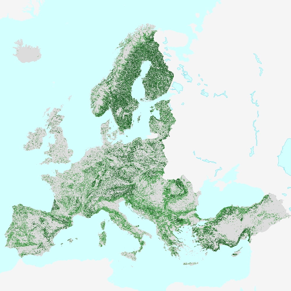
Forest Type 2018 (raster 100 m), Europe, 3-yearly, Oct. 2020
The High Resolution Layer (HRL) Forest Type (FTY) 2018 at 100 m spatial resolution is an aggregated version of the FTY layer at 10 m spatial reoslution, fully aligned with the EEA reference grid, and provides a forest classification with 3 thematic classes (all non-forest areas / broadleaved forest / coniferous forest). The dataset is provided as a full mosaic covering EEA38 countries and the United Kingdom.
The production of the High Resolution forest layers was coordinated by the European Environment Agency (EEA) in the frame of the EU Copernicus programme.
The high resolution forest product consists of three types of (status) products and additional change products. The status products are available for the 2012, 2015 and 2018 reference years: 1. Tree cover density providing level of tree cover density in a range from 0-100%; 2. Dominant leaf type providing information on the dominant leaf type: broadleaved or coniferous; 3. A Forest type product. The forest type product allows to get as close as possible to the FAO forest definition. In its original (20m) resolution it consists of two products: 1) a dominant leaf type product that has a MMU of 0.5 ha, as well as a 10% tree cover density threshold applied, and 2) a support layer that maps, based on the dominant leaf type product, trees under agricultural use and in urban context (derived from CLC and high resolution imperviousness 2009 data). For the final 100m product trees under agricultural use and urban context from the support layer are removed. The high resolution forest change products comprise a simple tree cover density change product for 2012-2015 (% increase or decrease of real tree cover density changes).
You can find more information about the product here: https://land.copernicus.eu/en/products/high-resolution-layer-forest-type/forest-type-2018.
Simple
Identification info
- Date (Creation)
- 2020-10-20
- Date (Publication)
- 2020-10-20
- Edition
-
01.00
- Citation identifier
- copernicus_r_3035_100_m_fty-2018_p_2018_v01_r00
Identifier
- Status
- Superseded
- Point of contact
-
Organisation Individual Electronic mail address Website Role European Commission
Owner Copernicus Land Monitoring Service
Custodian European Environment Agency
Publisher Copernicus Land Monitoring Service helpdesk
Point of contact
- Spatial representation type
- Grid
Spatial resolution
- Spatial resolution
- 100 m
- Topic category
-
- Environment
- Imagery base maps earth cover
Extent
Temporal extent
- Time period
- 2018-03-01 2018-10-31
Extent
))
- Maintenance and update frequency
- Continual
- Continents, countries, sea regions of the world.
-
-
United Kingdom
-
EEA38 (from 2020)
-
Resource constraints
- Access constraints
- Other restrictions
- Other constraints
- no limitations to public access
Resource constraints
- Use constraints
- Other restrictions
- Other constraints
-
The Copernicus component is governed by Regulation (EU) No 2021/696 of the European Parliament and of the Council of 28 April 2021 establishing the Union Space Programme and the European Union Agency for the Space Programme and repealing Regulations (EU) No 912/2010, (EU) No 1285/2013 and (EU) No 377/2014 and Decision No 541/2014/EU. Within the Copernicus component, a portfolio of land monitoring activities has been delegated by the European Union to the European Environment Agency (EEA) and the DG Joint Research Centre of the European Commission.
The Copernicus land monitoring products and services are made available on a principle of full, open and free access, as established by the Commission Delegated Regulation (EU) No 1159/2013 of 12 July 2013.
Free, full and open access to the products and services of the Copernicus Land Monitoring Service is made on the conditions that:
1. When distributing or communicating Copernicus Land Monitoring Service products and services (data, software scripts, web services, user and methodological documentation and similar) to the public, users shall inform the public of the source of these products and services.
2. Where the Copernicus Land Monitoring Service products and services have been adapted or modified by the user, the user shall clearly state this.
3. Users shall make sure not to convey the impression to the public that the user's activities are officially endorsed by the European Union.
- Language
- English
- Character encoding
- UTF8
Distribution Information
Data quality info
- Hierarchy level
- Dataset
Report
Result
- Title
- Commission Regulation (EU) No 1089/2010 of 23 November 2010 implementing Directive 2007/2/EC of the European Parliament and of the Council as regards interoperability of spatial data sets and services
- Date (Publication)
- 2010-12-08
- Explanation
-
See the referenced specification
Resource lineage
- Statement
-
The Forest Type 2018 status layer at 10m spatial resolution is mainly based on the primary status layer Dominant Leaf Type 2018, which was produced by a hierarchical spatio-temporal classification of time features derived from Sentinel-2A+B time series (Level-2A data) using a Random Forest (RF) classifier with 500 trees. The default time window ranges from 01-03-2018 to 31-10-2018 and was adapted to regional conditions where needed. In total, 147 statistical time features have been calculated using more than 500,000 samples, automatically collected from the LUCAS 2018 database and various CLMS products plus additional manual sampling. First, a binary Tree Cover Mask (TCM) with 2 classes (all non-tree covered areas / tree cover) has been generated. Various post-processing steps have been applied in order to improve the quality of the mask (e.g. correction of omission errors caused by the topographic overcorrection within the native Sentinel-2 Level-2A input data). Subsequently, the dominant leaf type has been separately classified within the confines of the Tree Cover Mask. In order to generate a forest type product following the FAO forest definition, a minimum mapping unit of 0.5 ha has been applied to the initial Tree Cover Mask considering a 10% tree cover density threshold and with all pixels in agricultural and urban context (as provided by the FADSL) removed. Subsequently, filtered non-forest patches smaller the MMU have been filled with the neighbouring leaf type information using a 9x9 circle filter. In case of tree covered pixels smaller 10% TCD being present in those non-forest patches, the original Dominant Leaf Type information is kept. National FTY products are derived through reprojection and might show a broken MMU.
For the 100m aggregated layer, the 100m (aggregated) pixel is assigned the class from the corresponding 10m pixels value covering more than 50% (rule-based spatial aggregation).
Quality assurance follows the ISO 9001:2015 standards for Quality Management and comprises of dedicated procedures of quality checks (QA breakpoints) during implementation of the production chain, in order to keep persistent control over the various stages of production, assure fitness-for-purpose of the end-products and that all quality requirements are fulfilled. Priority has been given to the target thematic accuracy to be achieved by each product, as well as to the issues of product consistency (spatial, thematic, temporal) and homogeneity. Quality Assessment: The quality assessment has been performed according to INSPIRE Data Specifications. The data quality elements considered are: (i) Completeness, (ii) Logical Consistency, (iii) positional accuracy, (iv) Thematic Accuracy, (v) Temporal quality and (vi) Usability.
Geometric accuracy (positioning scale): Less than one pixel (10m) according to ortho-rectified satellite image base (Sentinel-2 Level-2A) delivered by ESA.
Thematic accuracy at pan-European level: determined by the accuracies of the input source layers Dominant Leaf Type, Tree Cover Density and Forest Additional Support Layer (including CLC 2018 and HRL Imperviousness 2018 data). The thematic accuracy of the FTY product has not been assessed.
- Hierarchy level
- Dataset
Reference System Information
Reference System Information
- Code
- EPSG:3035
- Maintenance and update frequency
Metadata
- Metadata identifier
- db1af59f-f01f-4bd4-830c-f0eb652500c1
- Language
- English
- Character encoding
- UTF8
- Contact
-
Organisation Individual Electronic mail address Website Role European Environment Agency
Point of contact
Type of resource
- Resource type
- Dataset
- Metadata linkage
-
https://sdi.eea.europa.eu/geonetwork/srv/api/records/db1af59f-f01f-4bd4-830c-f0eb652500c1
- Date info (Creation)
- 2020-10-29T11:58:18Z
- Date info (Revision)
- 2025-10-09T11:18:10.43704Z
Metadata standard
- Title
-
ISO 19115/19139
- Edition
-
1.0
)))