EEA geospatial data catalogue
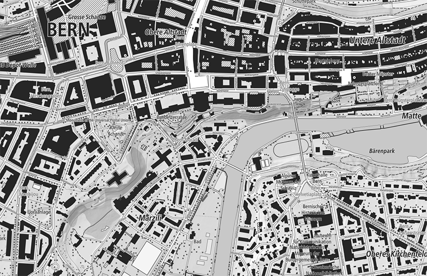
swissTLM-Map (grey)
swissTLM-Map is an automatically generated map which offers a complement to the national maps in the scale range 1:5'000 to 1:10'000. swissTLM-Map is based on the data of the topographic landscape model swissTLM3D complemented by the contours and hillshade of the digital elevation model swissALTI3D.
Simple
- Alternate title
-
Map swissTLM (grey)
- Date (Publication)
- 2024-04-24
- Date (Revision)
- 2024-03-06
- Date (Creation)
- 2012-01-01
- Edition
-
Version 2.2
- Edition date
- 2024-03-06
- Citation identifier
- ch.swisstopo.swisstlm3d-karte-grau
Citation identifier
- Collective title
-
topographical landscape model (national survey)
- Status
- On going
- Point of contact
-
Organisation name Individual name Electronic mail address Website Role Federal Office of Topography swisstopo
http://www.swisstopo.ch Point of contact
- Maintenance and update frequency
- Annually
- Maintenance note
-
The existing data was migrated into the TLM as a basis. The data is then updated based on an update cycle of 6 years and improvements and additions are made to the geometries and attributes. Parallel to the six-year update process, an annual update is carried out through the integration of data from so-called reference partners for selected topics. Initially, this annual update is implemented mainly for the administrative boundaries, buildings and road links. The official cadastral survey plays an important role as a reference partner in this process. The nomenclature for updating names are also integrated from the official cadastral survey.
-
GEMET
-
-
public transport
-
vector
-
geographic information system
-
-
geocat.ch
-
-
contour line
-
single object
-
landscape model
-
base map
-
opendata.swiss
-
GIS (Geographic Information System)
-
traffic network
-
-
GEMET - INSPIRE themes, version 1.0
-
-
Hydrography
-
Land cover
-
Geographical names
-
-
geocat.ch
-
-
FSDI Federal Spatial Data Infrastructure
-
-
geocat.ch
-
-
topography
-
-
GEMET
-
-
map chart
-
- Use constraints
- Other restrictions
- Other constraints
-
NonCommercialAllowed-CommercialAllowed-ReferenceRequired
- Aggregate Datasetindentifier
- 73856ca2-f21d-4cc9-90f6-f3e8375555df
- Association Type
- Larger work citation
- Spatial representation type
- Grid
- Denominator
- 5000
- Denominator
- 25000
- Language of dataset
- ger
- Character set
- UTF8
- Topic category
-
- Imagery base maps earth cover
Extent
- Description
-
Switzerland
))

Extent
- Description
-
Liechtenstein
))

- Reference system identifier
- EPSG:21781
- Reference system identifier
- EPSG:2056
- Reference system identifier
- EPSG:5728
- Distribution format
-
- GeoTIFF (GEOTIFF) ()
- OnLine resource
-
Protocol Linkage Name MAP:Preview
https://map.geo.admin.ch/?layers=ch.swisstopo.swisstlm3d-karte-grau Preview map.geo.admin.ch
OGC:WMS
https://wms.geo.admin.ch/?SERVICE=WMS&VERSION=1.3.0&REQUEST=GetCapabilities&lang=de ch.swisstopo.swisstlm3d-karte-grau
OGC:WMTS
https://wmts.geo.admin.ch/EPSG/3857/1.0.0/WMTSCapabilities.xml?lang=de ch.swisstopo.swisstlm3d-karte-grau
- OnLine resource
-
Protocol Linkage Name WWW:LINK
https://www.swisstopo.admin.ch/de/landschaftsmodell-swisstlm3d swissTLM3D
- OnLine resource
-
Protocol Linkage Name CHTOPO:specialised-geoportal
http://map.geo.admin.ch/?Y=660000&X=190000&zoom=1&bgLayer=voidLayer&layers=ch.swisstopo.swisstlm3d-karte-grau&layers_opacity=1&layers_visibility=true&time_current=latest&lang=de OPENDATA:SWISS
https://opendata.swiss/de/perma/ea59f826-b408-4657-a393-6fec178b2e30@bundesamt-fur-landestopografie-swisstopo Permalink opendata.swiss
- Hierarchy level
- Dataset
- Statement
-
Geometric accuracy: swissTLM3D (0.2 -1.5 m in all three dimensions for well-defined landscape features such as roads and buildings, 1 - 3 m in all three dimensions for landscape features which are not clearly defined such as forests)
- Included with dataset
- Title
-
Objektkatalog swissTLM3D 2.2
- Date (Revision)
- 2024-03-06
Metadata
- File identifier
- ea59f826-b408-4657-a393-6fec178b2e30 XML
- Metadata language
- ger
- Character set
- UTF8
- Hierarchy level
- Dataset
- Date stamp
- 2023-05-08T12:09:06.62Z
- Metadata standard name
-
GM03 2+
- Metadata author
-
Organisation name Individual name Electronic mail address Website Role Federal Office of Topography swisstopo
http://www.swisstopo.admin.ch Point of contact
- Other language
-
Language Character encoding French UTF8 Italian UTF8 English UTF8 Romansh UTF8 German UTF8