 EEA geospatial data catalogue
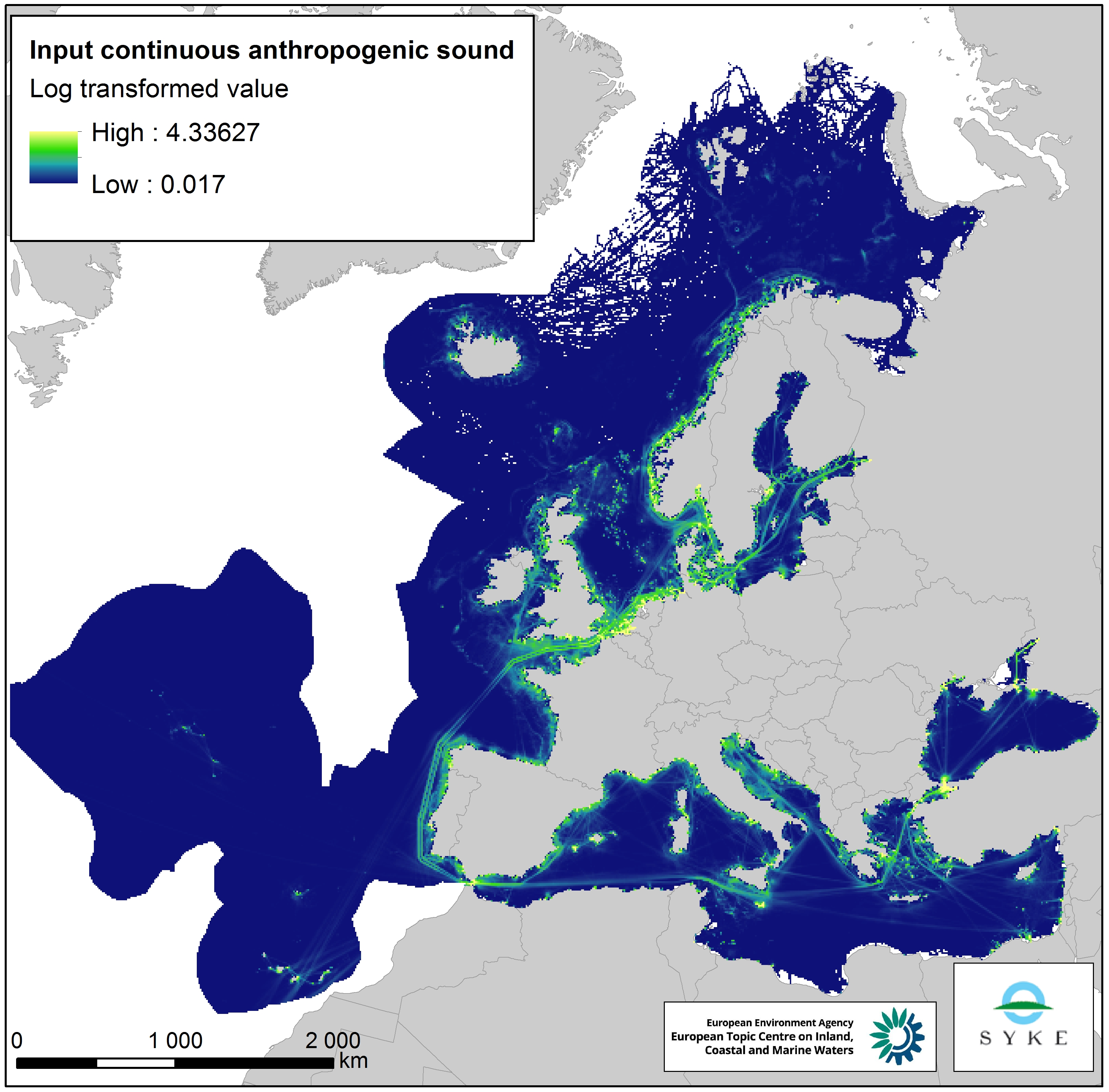
Input of continuous anthropogenic sound in Europe Seas, Jan. 2020
This raster dataset represents the input of continuous anthropogenic sound in the European Seas. Continuous anthropogenic underwater noise is found in the entire European marine area and is mainly produced by maritime traffic. As no thresholds for pressure have been agreed yet, even areas of low or infrequent maritime traffic are included as pressures. This dataset uses shipping density as a representation of distribution of continuous underwater noise.
This dataset is based on a truncated version of the EMODnet (Automatic Identification System) AIS based vessel density dataset for 2017 (all ships, year average). The vessel density was rescaled from a 1 km to 10 km resolution (mean values) using the EEA 10 km grid. The dataset has been transformed to a logarithmic scale (ln1).
This dataset has been prepared for the calculation of the combined effect index, produced for the ETC/ICM Report 4/2019 "Multiple pressures and their combined effects in Europe's seas" available on: https://www.eionet.europa.eu/etcs/etc-icm/etc-icm-report-4-2019-multiple-pressures-and-their-combined-effects-in-europes-seas-1.
Simple
- Date (Creation)
- 2019-05-01
- Date (Publication)
- 2020-01-27
- Edition
-
01.00
- Citation identifier
- eea_r_3035_10_km_cont-anthrop-sound_p_2017_v01_r00
- Point of contact
-
Organisation name Individual name Electronic mail address Website Role European Environment Agency
http://www.eea.europa.eu Point of contact European Environment Agency
http://www.eea.europa.eu Custodian
Point of contact
- Maintenance and update frequency
- As needed
- Keywords
-
- Keywords
-
-
GEMET
-
-
traffic noise
-
noise emission
-
ship
-
noise
-
sea
-
environmental pressure
-
pressure
-
-
Continents, countries, sea regions of the world.
-
-
Ionian Sea
-
Kattegat
-
Barents Sea
-
Bay of Biscay
-
Mediterranean Sea
-
North Sea
-
Norwegian Sea
-
Northeast Atlantic Ocean (40W)
-
Black Sea
-
Adriatic Sea
-
Iceland Sea
-
Celtic Sea
-
Baltic Sea
-
English Channel
-
-
Spatial scope
-
-
European
-
-
EEA topics
-
-
Noise
-
Pollution
-
Transport and mobility
-
Seas and coasts
-
- Access constraints
- Other restrictions
- Other constraints
- no limitations to public access
- Use constraints
- Other restrictions
- Other constraints
-
EEA standard re-use policy: unless otherwise indicated, re-use of content on the EEA website for commercial or non-commercial purposes is permitted free of charge, provided that the source is acknowledged ( http://www.eea.europa.eu/legal/copyright). Copyright holder: European Environment Agency (EEA).
- Spatial representation type
- Grid
- Distance
- 10 km
- Language of dataset
- English
- Topic category
-
- Environment
- Oceans
))
- Begin date
- 2017-01-01
- End date
- 2017-12-31
- Coordinate reference system identifier
- EPSG:3035
- Distribution format
-
- GeoTIFF ( )
- OnLine resource
- Hierarchy level
- Dataset
Conformance result
- Title
-
Commission Regulation (EU) No 1089/2010 of 23 November 2010 implementing Directive 2007/2/EC of the European Parliament and of the Council as regards interoperability of spatial data sets and services
- Date (Publication)
- 2010-12-08
- Explanation
-
See the referenced specification
- Statement
-
A truncated version of the EMODnet AIS based vessel density dataset (2017, all ships, year average, see on: https://www.emodnet-humanactivities.eu/search-results.php?dataname=Vessel+Density+) was used to represent input of continuous anthropogenic sound. Density values over 100 were truncated to 100, as these very large values are presumed to be caused by stationary and idling ships that have their AIS transponder turned on. The vessel density was rescaled from a 1 km resolution to 10 km (EEA 10 km grid) by calculating the mean. The dataset has been transformed to a logarithmic scale (ln1).
Metadata
- File identifier
- 0ab524a2-fd09-4185-adc8-58998efe8f23 XML
- Metadata language
- English
- Character set
- UTF8
- Hierarchy level
- Dataset
- Date stamp
- 2020-11-20T15:12:21
- Metadata standard name
-
ISO 19115/19139
- Metadata standard version
-
1.0
- Metadata author
-
Organisation name Individual name Electronic mail address Website Role European Environment Agency
Point of contact
)))