 EEA geospatial data catalogue
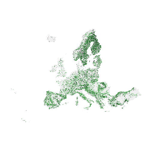
Forest Type 2012 (raster 100 m), Europe, 3-yearly, Apr. 2018
The high resolution forest product consists of three types of (status) products and additional change products. The status products are available for the 2012 and 2015 reference years: 1. Tree cover density providing level of tree cover density in a range from 0-100%; 2. Dominant leaf type providing information on the dominant leaf type: broadleaved or coniferous; 3. A Forest type product. The forest type product allows to get as close as possible to the FAO forest definition. In its original (20m) resolution it consists of two products: 1) a dominant leaf type product that has a MMU of 0.5 ha, as well as a 10% tree cover density threshold applied, and 2) a support layer that maps, based on the dominant leaf type product, trees under agricultural use and in urban context (derived from CLC and high resolution imperviousness 2009 data). For the final 100m product trees under agricultural use and urban context from the support layer are removed. The high resolution forest change products comprise a simple tree cover density change product for 2012-2015 (% increase or decrease of real tree cover density changes).
The production of the high resolution forest layers was coordinated by the European Environment Agency (EEA) in the frame of the EU Copernicus programme.
Simple
Identification info
- Date (Creation)
- 2018-04-30
- Date (Publication)
- 2018-04-30
- Edition
-
02.00
- Citation identifier
- copernicus_r_3035_100_m_fty-2012_p_2011-2013_v02_r00
Identifier
- Point of contact
-
Organisation Individual Electronic mail address Website Role European Commission
Owner Copernicus Land Monitoring Service
Custodian European Environment Agency
Publisher Copernicus Land Monitoring Service helpdesk
Point of contact
- Spatial representation type
- Grid
Spatial resolution
- Spatial resolution
- 100 m
- Topic category
-
- Environment
- Imagery base maps earth cover
Extent
Temporal extent
- Time period
- 2011-01-01 2013-12-31
Extent
))
))
- Maintenance and update frequency
- Continual
- GEMET - INSPIRE themes, version 1.0
-
-
Land cover
-
- Continents, countries, sea regions of the world.
-
-
EEA39
-
- GEMET
-
-
land use
-
landscape alteration
-
land cover
-
forest management
-
- EEA topics
-
-
Land use
-
Forests and forestry
-
Biodiversity
-
Resource constraints
- Access constraints
- Other restrictions
- Other constraints
- no limitations to public access
Resource constraints
- Use constraints
- Other restrictions
- Other constraints
-
The Copernicus component is governed by Regulation (EU) No 2021/696 of the European Parliament and of the Council of 28 April 2021 establishing the Union Space Programme and the European Union Agency for the Space Programme and repealing Regulations (EU) No 912/2010, (EU) No 1285/2013 and (EU) No 377/2014 and Decision No 541/2014/EU. Within the Copernicus component, a portfolio of land monitoring activities has been delegated by the European Union to the European Environment Agency (EEA) and the DG Joint Research Centre of the European Commission.
The Copernicus land monitoring products and services are made available on a principle of full, open and free access, as established by the Commission Delegated Regulation (EU) No 1159/2013 of 12 July 2013.
Free, full and open access to the products and services of the Copernicus Land Monitoring Service is made on the conditions that:
1. When distributing or communicating Copernicus Land Monitoring Service products and services (data, software scripts, web services, user and methodological documentation and similar) to the public, users shall inform the public of the source of these products and services.
2. Where the Copernicus Land Monitoring Service products and services have been adapted or modified by the user, the user shall clearly state this.
3. Users shall make sure not to convey the impression to the public that the user's activities are officially endorsed by the European Union.
Associated resource
- Association Type
- Revision Of
- Metadata Reference
- Language
- English
- Character encoding
- UTF8
Distribution Information
Data quality info
- Hierarchy level
- Dataset
Report
Result
- Title
- Commission Regulation (EU) No 1089/2010 of 23 November 2010 implementing Directive 2007/2/EC of the European Parliament and of the Council as regards interoperability of spatial data sets and services
- Date (Publication)
- 2010-12-08
- Explanation
-
See the referenced specification
Resource lineage
- Statement
-
Semi-automatic classification of pre-processed multitemporal High Resolution (HR) satellite image data (IRS-p6, ResourceSat-2, SPOT-4, SPOT-5) with reference year 2012 (+/- 1 year), using supervised and unsupervised elements, leading to scene-based binary masks of tree cover. Subsequently, a supervised classification of the dominant leaf type (broadleaved and coniferous) has been performed, considering the DLT 2015 product as a reference. Finally, interactive manual corrections of the derived tree cover mask have been performed and integrated to a seamless mosaic. The thereof derived Dominant Leaf Type (DLT) product has been intersected with the Tree Cover Density (TCD) product considering a 10% density threshold and subsequently filtered with a Minimum Mapping Unit (MMU) of 0.5 ha. Thus, the derived Forest Type (FTY) product is largely following the forest definition of the Food and Agriculture Organization (FAO). Geometric accuracy (positioning scale): Less than one pixel according to ortho-rectified satellite image base delivered by ESA. Thematic accuracy: Determined by the accuracy of the source Tree Cover Density and Dominant Leaf Type in 20m spatial resolution.
Quality assurance follows the ISO9000 standards for Quality Management and comprises of dedicated procedures of ongoing quality checks (QA breakpoints) during implementation of the production chain, in order to keep persistent control over the various stages of production, assure fitness-for-purpose of the end-products and that all quality requirements are fulfilled. Priority has been given to the target thematic accuracies to be achieved by each product, as well as to the issues of product consistency (spatial, thematic, temporal) and homogeneity. Quality Assessment: The quality assessment has been performed according to INSPIRE Data Specifications. The data quality elements considered are:
(i) Completeness,
(ii) Logical Consistency,
(iii) Thematic Accuracy,
(iv) Temporal quality and
(v) Usability.
Each of them (excl. the Thematic Accuracy hereafter) forms a section in the QA/QC Procedures.
- Hierarchy level
- Dataset
Reference System Information
Reference System Information
- Code
- EPSG:3035
- Maintenance and update frequency
Metadata
- Metadata identifier
- 8367f5f3-5eb1-4d89-ae8d-13a70fc834e0
- Language
- English
- Character encoding
- UTF8
- Contact
-
Organisation Individual Electronic mail address Website Role European Environment Agency
Point of contact
Type of resource
- Resource type
- Dataset
- Metadata linkage
-
https://sdi.eea.europa.eu/geonetwork/srv/api/records/8367f5f3-5eb1-4d89-ae8d-13a70fc834e0
- Date info (Creation)
- 2018-06-27T08:17:37Z
- Date info (Revision)
- 2025-10-09T11:00:49.944549Z
Metadata standard
- Title
-
ISO 19115/19139
- Edition
-
1.0
),POLYGON((44.8212%2034.5619,44.8212%2071.1855,-10.6198%2071.1855,-10.6198%2034.5619,44.8212%2034.5619))))