 EEA geospatial data catalogue
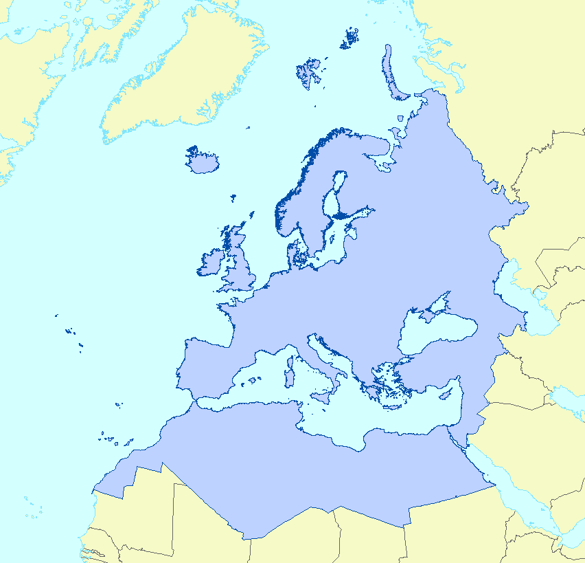
EEA coastline for analysis (polygon) - version 3.0, March 2017
The EEA coastline dataset is created for detailed analysis with a Minimum Mapping Unit of e.g. 1:100000, for geographical Europe. The coastline is a hybrid product obtained from satellite imagery from two projects:
1) EUHYDRO (Pan-European hydrographic and drainage database) [ https://land.copernicus.eu/pan-european/satellite-derived-products/eu-hydro/view] and
2) GSHHG (A Global Self-consistent, Hierarchical, High-resolution Geography Database) [ http://www.soest.hawaii.edu/pwessel/gshhg/].
The defining criteria was altitude level = 0 from EUDEM [ https://land.copernicus.eu/pan-european/satellite-derived-products/eu-dem/view]. Outside the coverage of the EUDEM, the coastline from GSHHG was used without modifications. A few manual amendments to the dataset were necessary to meet requirements from EU Nature Directives, Water Framework Directive and Marine Strategy Framework Directive. In 2015, several corrections were made in the Kalogeroi Islands (coordinates 38.169, 25.287) and two other Greek little islets (coordinates 36.766264, 23.604318), as well as in the peninsula of Porkkala (around coordinates 59.99, 24.42).
In this revision (v3, 2017), 2 big lagoons have been removed from Baltic region, because, according to HELCOM, are freshwater lagoons.
This dataset is a polygon usable as a water-land mask.
Simple
Identification info
- Date (Creation)
- 2017-03-01
- Date (Publication)
- 2017-03-01
- Edition
-
3.0
- Citation identifier
- eea_v_3035_100_k_coastline-poly_p_1995-2017_v03_r00
- Citation identifier
- DAT-132-en
- Point of contact
-
Organisation Individual Electronic mail address Website Role European Environment Agency
Point of contact European Environment Agency
Custodian
- Spatial representation type
- Vector
Spatial resolution
Equivalent scale
- Denominator
- 100000
- Topic category
-
- Oceans
- Elevation
Extent
))
Extent
Temporal extent
- Time period
- 1995-08-01 2017-12-31
- Maintenance and update frequency
- As needed
- EEA Management Plan
-
-
2018 2.6.1
-
Resource constraints
- Use constraints
- Other restrictions
- Other constraints
-
License CC-BY 4.0 ( https://creativecommons.org/licenses/by/4.0/). Copyright holder: European Environment Agency (EEA).
Resource constraints
- Access constraints
- Other restrictions
- Other constraints
- no limitations to public access
- Language
- English
- Character encoding
- UTF8
Distribution Information
Data quality info
- Hierarchy level
- Dataset
Report
Result
- Title
- Commission Regulation (EU) No 1089/2010 of 23 November 2010 implementing Directive 2007/2/EC of the European Parliament and of the Council as regards interoperability of spatial data sets and services
- Date (Publication)
- 2010-12-08
- Explanation
-
See the referenced specification
Resource lineage
- Statement
-
Polygon: the polygon was derived from the parent dataset by adding two straight lines, one North-to-South, at the East-most part of the parent dataset, and the second one West-to-East, at the South–most part of the parent dataset. These 2 lines are taken from the NGA-derived coastline produced by the ETC-BD in 2008. Then a polygon dataset is created using the ArcGIS tool “Feature to Polygon”.
The Baltic lagoons have been modified with the data from SVAR geodatabase version 2012_2, Swedish Meteorological and Hydrological Institute (SMHI).
- Hierarchy level
- Dataset
Reference System Information
Reference System Information
- Code
- EPSG:3035
Metadata
- Metadata identifier
- 9faa6ea1-372a-4826-a3c7-fb5b05e31c52
- Language
- English
- Character encoding
- UTF8
- Contact
-
Organisation Individual Electronic mail address Website Role European Environment Agency
Point of contact
Type of resource
- Resource type
- Dataset
- Metadata linkage
-
https://sdi.eea.europa.eu/catalogue/srv/api/records/9faa6ea1-372a-4826-a3c7-fb5b05e31c52
- Date info (Creation)
- 2018-04-05T08:12:57Z
- Date info (Revision)
- 2026-01-22T10:57:15.491469Z
Metadata standard
- Title
-
ISO 19115/19139
- Edition
-
1.0
)))