 EEA geospatial data catalogue
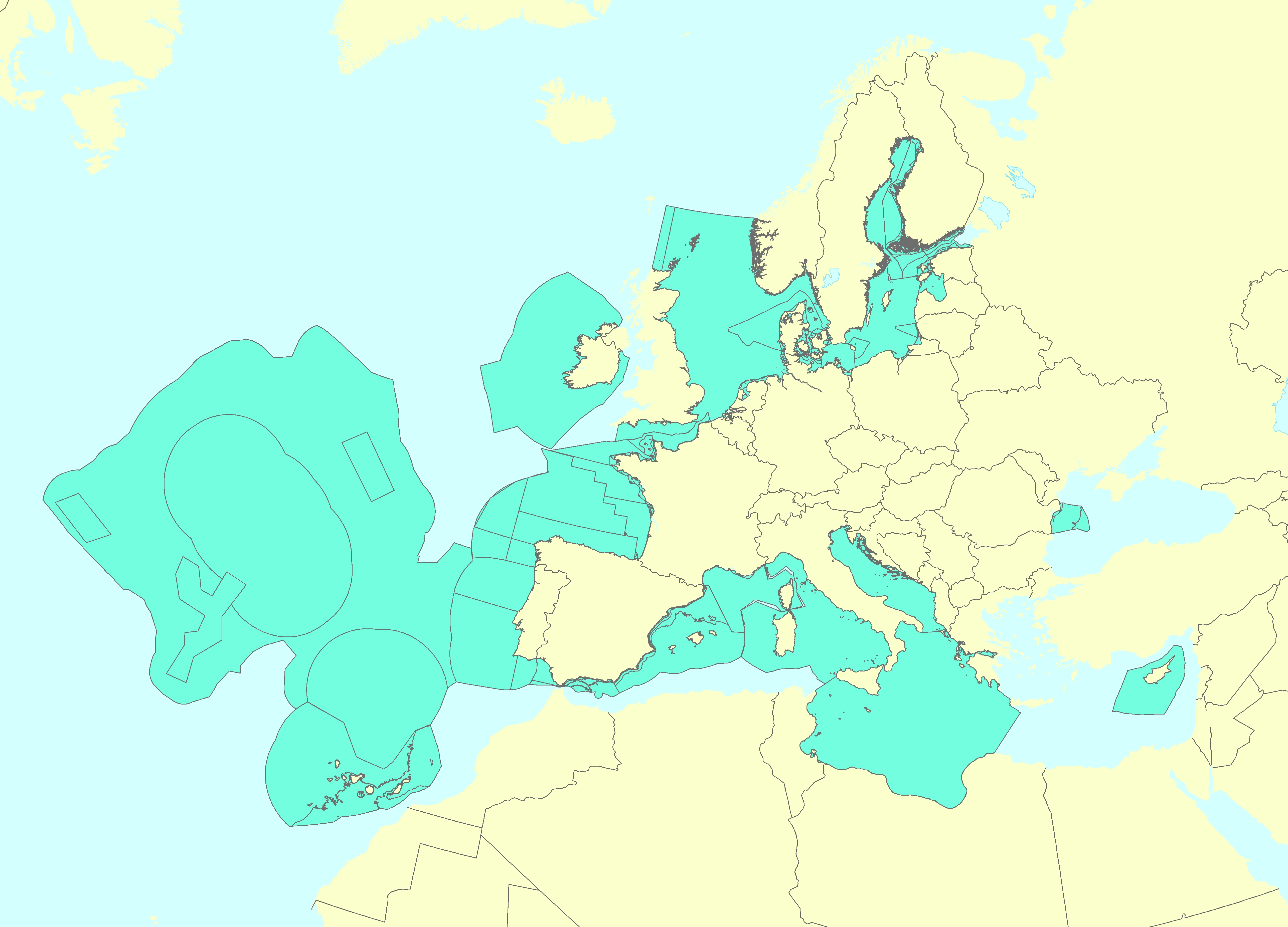
Marine Reporting Units used in Marine Strategy Framework Directive (MSFD) 2018-2024 reporting cycle - version 2.0, Jun. 2020
The Marine Reporting Units (MRUs) are used within the reporting obligations of the Marine Strategy Framework Directive (MSFD) in order to link the implementation of the different articles to specific marine areas. The MRUs can be of varying sizes, according to the appropriate scale for the different reports (e.g. region, sub-region, regional or sub-regional subdivision, Member State marine waters, WFD coastal waters, etc.), as indicated in the Good Environmental Status 2017 Decision.
The present data set is the second public version released of the MRUs used during the MSFD 2018 reporting exercise on the update of Articles 8, 9 and 10. Only the MRUs of those countries that have gone through the reporting exercise by June 2020 have been included in this data set. Apart from the countries included already in version 1 of the dataset (SE, FI, EE, LV, PL, DE, DK, NL, BE, FR, ES, HR and RO), this version also includes seven more countries, namely MT, LT, IT, SI, CY, PT and IE.
The data set is distributed in SHP and in INSPIRE-compliant GML format, made available also through an INSPIRE compliant ATOM service.
Simple
Identification info
- Date (Creation)
- 2020-06-24
- Date (Publication)
- 2020-06-24
- Edition
-
02.00
- Citation identifier
- eea_v_4258_100_k_mru-msfd2018_i_2018-2019_v02_r00
- Status
- Superseded
- Point of contact
-
Organisation Individual Electronic mail address Website Role European Environment Agency
Point of contact European Environment Agency
Custodian
- Spatial representation type
- Vector
Spatial resolution
Equivalent scale
- Denominator
- 100000
- Topic category
-
- Environment
- Oceans
Extent
))
Temporal extent
- Time period
- 2018-10-16 2020-06-30
- Maintenance and update frequency
- As needed
- GEMET
-
-
sea
-
marine environment
-
Marine Strategy Framework Directive
-
- Continents, countries, sea regions of the world.
-
-
Latvia
-
Cyprus
-
Netherlands
-
Italy
-
Finland
-
Croatia
-
Spain
-
Baltic Sea
-
Estonia
-
Romania
-
Poland
-
Malta
-
Slovenia
-
Sweden
-
Mediterranean Sea
-
Ireland
-
Belgium
-
Denmark
-
Germany
-
Lithuania
-
Northeast Atlantic Ocean (40W)
-
Black Sea
-
France
-
Portugal
-
- Spatial scope
-
-
European
-
- INSPIRE priority data set
-
-
Directive 2008/56/EC
-
Marine reporting units (Marine Strategy Framework Directive)
-
- EEA topics
-
-
Seas and coasts
-
Resource constraints
- Access constraints
- Other restrictions
- Other constraints
- no limitations to public access
Resource constraints
- Use constraints
- Other restrictions
- Other constraints
-
License CC-BY 4.0 ( https://creativecommons.org/licenses/by/4.0/). Copyright holder: European Environment Agency (EEA).
Associated resource
- Association Type
- Revision Of
Associated resource
- Association Type
- Cross reference
- Metadata Reference
Associated resource
- Association Type
- Cross reference
Associated resource
- Association Type
- Cross reference
- Language
- English
Distribution Information
- Distribution format
-
-
SHP
-
GML
-
- OnLine resource
-
INSPIRE compliant Atom service
- OnLine resource
-
Direct download
Data quality info
- Hierarchy level
- Dataset
Report
Result
- Title
- Commission Regulation (EU) No 1089/2010 of 23 November 2010 implementing Directive 2007/2/EC of the European Parliament and of the Council as regards interoperability of spatial data sets and services
- Date (Publication)
- 2010-12-08
- Explanation
-
See the referenced specification
- Pass
- true
Resource lineage
- Statement
-
The present MRUs data set is a compilation of the layers submitted by Member States (in SHP format) to the European Commission in the context of the 2018 MSFD reporting exercise (update of Articles 8, 9 and 10). The pan-European data set has been created in GML following the INSPIRE 'Area management / restriction / regulation zones and reporting units' theme data specifications (available at https://inspire.ec.europa.eu/id/document/tg/am). For the development of the GML, a number of fields have been included and filled in with the criteria described in the document 'Development of a pan-European data set of Marine Reporting Units' (file "Documentation_MRUs_v1-1.pdf" provided with the data set). The data set has also been published as an INSPIRE-compliant ATOM web service. A shapefile format version has also been produced. The current version only includes those countries that have gone through the reporting exercise by June 2020. A new version of the data set will be produced including the MRUs of the countries expected to report during the second half of 2020.
- Hierarchy level
- Dataset
Reference System Information
Reference System Information
- Code
- EPSG:4258
Metadata
- Metadata identifier
- d1cddb75-fd90-4dc3-a17a-8c051406bf51
- Language
- English
- Character encoding
- UTF8
- Contact
-
Organisation Individual Electronic mail address Website Role European Environment Agency
Point of contact
Type of resource
- Resource type
- Dataset
- Metadata linkage
-
https://sdi.eea.europa.eu/geonetwork/srv/api/records/d1cddb75-fd90-4dc3-a17a-8c051406bf51
- Date info (Creation)
- 2020-06-24T13:04:17Z
- Date info (Revision)
- 2025-10-09T11:16:15.844093Z
Metadata standard
- Title
-
ISO 19115/19139
- Edition
-
1.0
)))