 EEA geospatial data catalogue
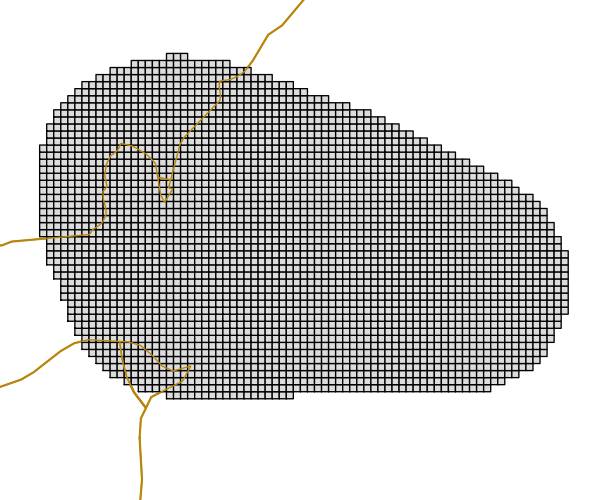
EEA reference grid for Gibraltar (1km), May 2013
The grid is based on proposal at the 1st European Workshop on Reference Grids in 2003 and later INSPIRE geographical grid systems. The sample grid available here is part of a set of three polygon grids in 1, 10 and 100 kilometres. The grids cover at least country borders and, where applicable, marine Exclusive Economic Zones v7.0, http://www.marineregions.org. Note that the extent of the grid into the marine area does not reflect the extent of the territorial waters .
Simple
Identification info
- Date (Publication)
- 2013-05-21
- Date (Creation)
- 2013-05-21
- Citation identifier
- eea_v_3035_1_km_eea-ref-grid-gi_p_2013_v02_r00
- Point of contact
-
Organisation Individual Electronic mail address Website Role European Environment Agency
Point of contact European Environment Agency
Custodian
- Spatial representation type
- Vector
Spatial resolution
- Spatial resolution
- 1 km
- Topic category
-
- Location
Extent
))
Extent
Temporal extent
- Time period
- 2013-01-01T00:00:00 2013-12-31T00:00:00
- EEA topics
-
-
Biodiversity
-
- GEMET - INSPIRE themes, version 1.0
-
-
Geographical grid systems
-
- Continents, countries, sea regions of the world.
-
-
Gibraltar
-
- GEMET
-
-
gridding
-
Resource constraints
- Use constraints
- Other restrictions
- Other constraints
-
License CC-BY 4.0 ( https://creativecommons.org/licenses/by/4.0/). Copyright holder: European Environment Agency (EEA).
Resource constraints
- Access constraints
- Other restrictions
- Other constraints
- no limitations to public access
- Language
- English
- Character encoding
- UTF8
Data quality info
- Hierarchy level
- Dataset
Report
Result
- Title
- Commission Regulation (EU) No 1089/2010 of 23 November 2010 implementing Directive 2007/2/EC of the European Parliament and of the Council as regards interoperability of spatial data sets and services
- Date (Publication)
- 2010-12-08
- Explanation
-
See the referenced specification
Resource lineage
- Statement
-
The reference grids are based on ETRS89 Lambert Azimuthal Equal Area projection with parameters: latitude of origin 52°N, longitude of origin 10°E, false northing 3210000.0m, false easting 4321000.0m. Origin of the grid is calculated from 0mN 0mE of projection. The method followed the instructions for the EEA fishnet tool described in the EEA GIS guideline available from http://www.eionet.europa.eu/gis. All grids have been created using one of the two scripts available in the scripts subfolder located in the data directory. Their usage is documented in the readme.txt file available in the same subfolder .
- Hierarchy level
- Dataset
Reference System Information
Reference System Information
- Code
- EPSG:3035
Metadata
- Metadata identifier
- f93fddaa-56ba-4536-a1db-698f64c8af3df
- Language
- English
- Character encoding
- UTF8
- Contact
-
Organisation Individual Electronic mail address Website Role European Environment Agency
Point of contact
Type of resource
- Resource type
- Dataset
- Metadata linkage
-
https://sdi.eea.europa.eu/catalogue/srv/api/records/f93fddaa-56ba-4536-a1db-698f64c8af3df
- Date info (Creation)
- 2013-05-23T08:34:09Z
- Date info (Revision)
- 2025-10-09T11:24:15.480048Z
Metadata standard
- Title
-
ISO 19115/19139
- Edition
-
1.0
)))