 EEA geospatial data catalogue
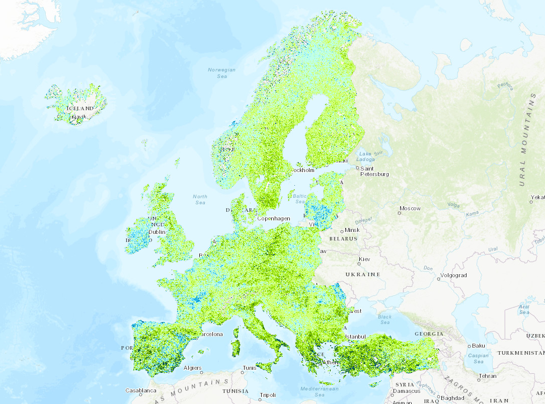
Trends in annual vegetation growing season length 2000-2016, version 1, Mar. 2019
The raster file is the temporal trend in the length of the vegetation growing season.
The length of growing season data set is based on the time series of the Plant Phenology Index (PPI) derived from the MODIS BRDF-Adjusted Reflectance product (MODIS MCD43 NBAR). The PPI index is optimized for efficient monitoring of vegetation phenology and is derived from the source MODIS data using radiative transfer solutions applied to the reflectance in visible-red and near infrared spectral domains. The season length indicator is based on calculating the start and end of the growing season from the annual PPI temporal curve using the TIMESAT software. Change growing season length was then calculated after fitting a linear trend and extracting the slope of the trend. Negative values refer to shortening vegetation growing season, whereas positive values refer to extending length of the vegetation growing season.
Simple
- Date (Publication)
- 2019-03-12
- Date (Creation)
- 2018-08-30
- Edition
-
01.00
- Citation identifier
- eea_r_3035_500_m_p-los-trend_p_2000-2016_v01_r00
- Citation identifier
- DAT-227-en
Point of contact
Point of contact
- Maintenance and update frequency
- As needed
- Keywords
-
- Keywords
-
-
GEMET
-
-
natural areas, landscape, ecosystems
-
biomass
-
land cover
-
biodiversity
-
remote sensing
-
index
-
vegetation
-
-
Continents, countries, sea regions of the world.
-
-
EEA39
-
-
EEA Management Plan
-
-
2019 1.8.2
-
-
EEA topics
-
-
Agriculture and food
-
Land use
-
- Access constraints
- Other restrictions
- Other constraints
- no limitations to public access
- Use constraints
- Other restrictions
- Other constraints
-
EEA standard re-use policy: unless otherwise indicated, re-use of content on the EEA website for commercial or non-commercial purposes is permitted free of charge, provided that the source is acknowledged ( http://www.eea.europa.eu/legal/copyright). Copyright holder: European Environment Agency (EEA).
- Aggregate Datasetindentifier
- 29ae2d47-7af2-4c09-ba5f-e2fbb7c2b0d1
- Association Type
- Cross reference
- Aggregate Datasetindentifier
- f4b01c76-29f7-4075-b13f-5dc5a9c18ae2
- Association Type
- Cross reference
- Aggregate Datasetindentifier
- 42012fdb-4612-41fb-a8f2-a195692ecf24
- Association Type
- Cross reference
- Aggregate Datasetindentifier
- f5e0c7e9-7c44-477f-950b-7c092fa0f7a8
- Association Type
- Cross reference
- Spatial representation type
- Grid
- Distance
- 500 m
- Language of dataset
- English
- Topic category
-
- Environment
))
- Begin date
- 2000-01-01
- End date
- 2016-12-31
- Coordinate reference system identifier
- EPSG:3035
- Distribution format
-
- BIL ( 2016)
- OnLine resource
- Hierarchy level
- Dataset
Conformance result
- Title
- Commission Regulation (EU) No 1089/2010 of 23 November 2010 implementing Directive 2007/2/EC of the European Parliament and of the Council as regards interoperability of spatial data sets and services
- Date (Publication)
- 2010-12-08
- Explanation
-
See the referenced specification
- Statement
-
The dataset computation steps are:
• Calculation of the PPI index from the MODIS MCD43 NBAR product
• Extraction of the start of growing season and end of growing season points from the annual PPI curve for all years between the 2000 – 2016 period.
• Calculating the length of the growing season, such as END of season - START of season
• Fitting a linear trend over the length of growing season the time series
• Extracting the slope of the linear trend
• Calculation of season length change: slope of the linear trend, expressed in day/year.
For detailed methodology of the LINT calculation please see the TIMESAT documentation available at: http://web.nateko.lu.se/timesat/timesat.asp?cat=6
Metadata
- File identifier
- 4635cd57-65d9-47b4-b18e-98a781ef27bb XML
- Metadata language
- English
- Character set
- UTF8
- Hierarchy level
- Dataset
- Date stamp
- 2024-01-16T12:29:40.773Z
- Metadata standard name
-
ISO 19115/19139
- Metadata standard version
-
1.0
- Metadata author
-
Organisation name Individual name Electronic mail address Website Role European Environment Agency
Point of contact
)))