 EEA geospatial data catalogue
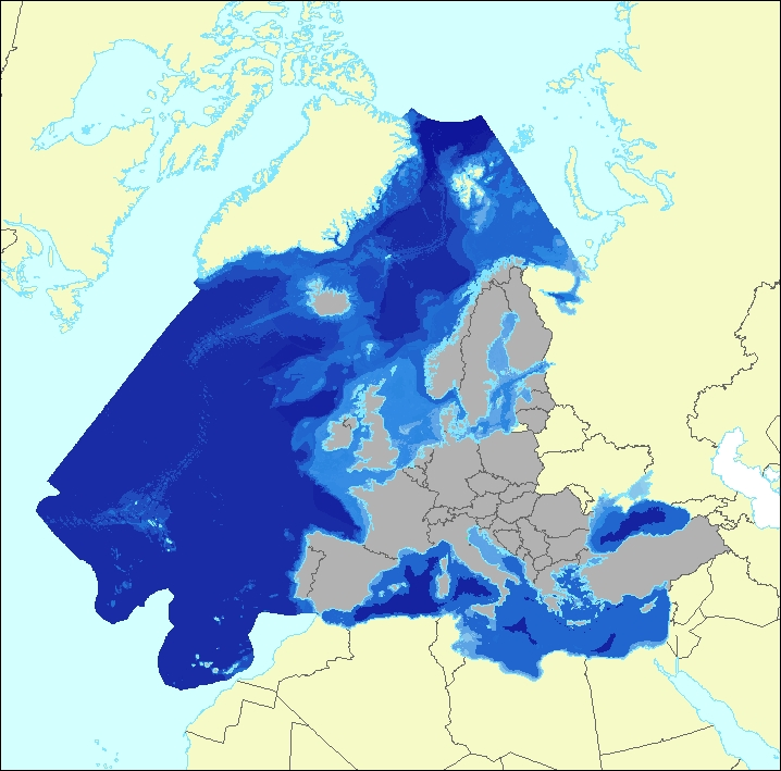
Ecosystem types of Europe 2012 - Marine habitats - version 3 revision 1, Feb. 2019
The data set aims to contribute to a better biological characterization of European marine ecosystems. As such it represents probabilities of EUNIS (EUropean Nature Information System) habitat presence at Level 3 for marine habitats including information on sea ice coverage (this corresponds to EUNIS level 2 for terrestrial habitats).
The map combines spatially explicit data on marine bathymetry and sea-bed with non-spatially referenced habitat information of the EUNIS classification. The objective of the data set produced by EEA and its Topic Centre ETC/ULS is to improve the biological description of marine based ecosystem types and their spatial distribution.
The work supports Target 2 Action 5 of the implementation of the EU Biodiversity Strategy to 2020, established to achieve the Aichi targets of the Convention of Biological Diversity (CBD). It further addresses the MAES process (Mapping and Assessing of Ecosystems and their Services). The data set represents 2 classes of the MAES classification level 3, namely “Marine inlets and transitional waters” and “Marine”.
The dataset comprises the following information:
• Sea region (1 – Arctic, 2 – Atlantic, 3 – Baltic, 4 – Mediterranean, 5 – Black Sea)
• Sea zone (1 – Littoral, 2 – Infralittoral, 3 – Circalittoral, 4 – Offshore circalittoral, 5 – Upper bathyal, 6 – Lower bathyal, 7 – Abyssal,8 - Coastal Lagoons, 9 - Coastal Lagoons)
• Substrate (0 – undetermined substrate, 1 – rock and biogenic, 3 – coarse sediment, 4 – mixed sediment, 5 – sand, 6 – mud)
• Sea ice coverage (0 – no sea ice presence, 1 – seasonal sea ice presence, 2 – perennial sea ice presence)
Simple
- Date (Creation)
- 2018-12-31
- Edition
-
03.01
- Citation identifier
- eea_r_3035_100_m_ecosystem-types-marine_p_2012_v03_r01
- Citation identifier
- DAT-146-en
- Point of contact
-
Organisation name Individual name Electronic mail address Website Role European Environment Agency
http://www.eea.europa.eu Point of contact European Environment Agency
Custodian
- Maintenance and update frequency
- As needed
-
GEMET - INSPIRE themes, version 1.0
-
-
Habitats and biotopes
-
Sea regions
-
Land cover
-
Oceanographic geographical features
-
- Keywords
-
- Keywords
-
-
Continents, countries, sea regions of the world.
-
-
EEA39
-
-
GEMET
-
-
ecosystem type
-
habitat
-
ecosystem
-
environmental assessment
-
land cover
-
-
EEA Management Plan
-
-
2018 1.7.5
-
-
EEA topics
-
-
Biodiversity
-
Land use
-
Seas and coasts
-
- Use limitation
-
EEA standard re-use policy: unless otherwise indicated, re-use of content on the EEA website for commercial or non-commercial purposes is permitted free of charge, provided that the source is acknowledged ( http://www.eea.europa.eu/legal/copyright). Copyright holder: European Environment Agency (EEA).
- Access constraints
- Other restrictions
- Other constraints
- no limitations to public access
- Spatial representation type
- Grid
- Distance
- 100 m
- Language of dataset
- English
- Topic category
-
- Biota
- Environment
- Oceans
))
- Begin date
- 2012-01-01
- End date
- 2012-12-31
- Coordinate reference system identifier
- EPSG:3035
- Distribution format
-
- GeoTIFF ( 1)
- OnLine resource
- Hierarchy level
- Dataset
Conformance result
- Title
-
Commission Regulation (EU) No 1089/2010 of 23 November 2010 implementing Directive 2007/2/EC of the European Parliament and of the Council as regards interoperability of spatial data sets and services
- Date (Publication)
- 2010-12-08
- Explanation
-
See the referenced specification
- Statement
-
The process of creation of this dataset is as follows:
A – Marine habitats Level 1
1. Create Sea mask, Sea Extent and Sea Region extended mask from CLC 2012 v18.5, Europe Seas 2010-2017 (vector 100k) and MSFD marine regions 2017 (vector 100k)
B – New EUNIS-crosswalks
2. Apply “EUSEAMAP/new EUNIS Crosswalk” to derive EUNIS Level 3 from EUSEAMAP 2017
3. Apply “Geology/new EUNIS Crosswalk” to derive seabed geology from EMODNET
C – Continental Shelf (for Mediterranean Region only)
4. Derive Mediterranean continental shelf and littoral mask from Continental marine margins, EMODNET bathymetry and Sea Regions extended mask
D – Marine habitats level 3 separate processing per each of the 5 sea regions
5. Apply Sea Region bathymetry rules to define sea zone
6. Apply Biological zone rules to extract biological zone per each sea region:
- Littoral
- Infralittoral
- Circalittoral
- Offshore Circalittoral
- Upper bathyal
- Lower bathyal
- Abyssal
E – Sea Ice (for Arctic and Baltic only)
7. Apply minimum and maximum Sea Ice extent to derive sea ice coverage for Arctic and Baltic region
F – Final Integration
8. Combine of all EUNIS maps (Cell statistics)
9. Euclidean Allocation for gap filling
10. Adjustment of final extent
H - Transitional habitats
11. Deriving "Estuaries" and "Coastal Lagoons" from CLC Accounting, Riparian Zones and Natura 2000
More information can be found in the ETC/BD Technical Paper 11/2018 "Ecosystem Type Map v3.1-Terrestrial and marine ecosystems" provided with the dataset (Ecosystem_mapping_v3_1.pdf).
Metadata
- File identifier
- aa791cf1-ead5-4364-b0c3-4c54dc83c7e4 XML
- Metadata language
- English
- Character set
- UTF8
- Hierarchy level
- Dataset
- Date stamp
- 2021-04-26T12:33:19.944Z
- Metadata standard name
-
ISO 19115/19139
- Metadata standard version
-
1.0
- Metadata author
-
Organisation name Individual name Electronic mail address Website Role European Environment Agency
Point of contact
)))