 EEA geospatial data catalogue
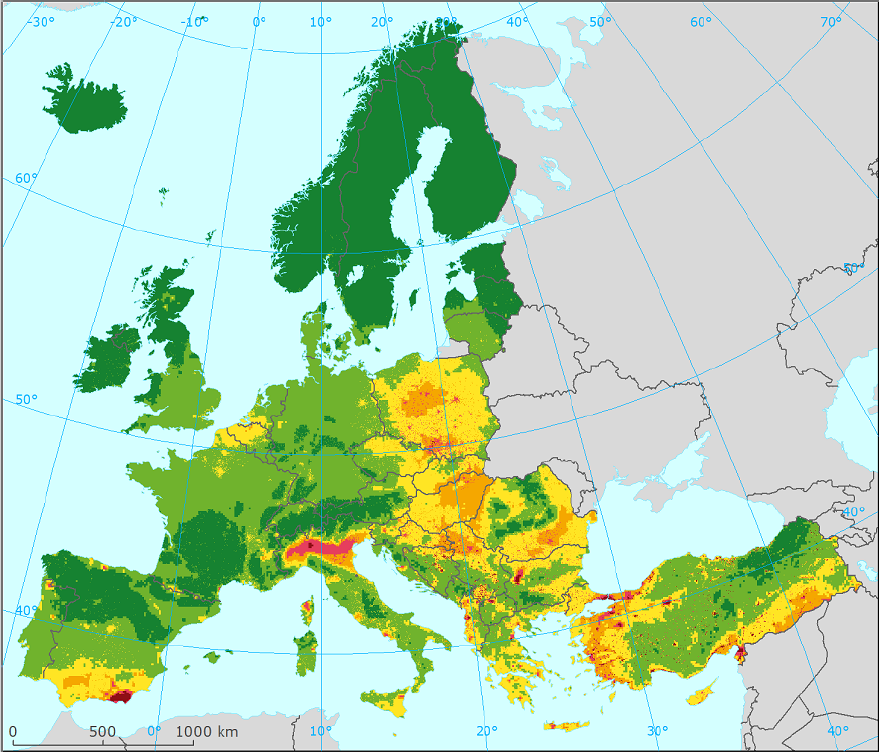
European air quality data for 2016 (interpolated data and station points), Apr. 2019
The data set provides the EEA 1 km and 2 km grids combining the monitoring air quality data in a ‘regression-interpolation-merging mapping’ methodology and the observational values of the air quality monitoring stations used in the interpolation. The full data set covers Europe for the year 2016, and in particular for the pollutants PM10, PM2.5, O3, NO2 and NOx.
This data set is used to estimate population and vegetation exposure to air pollution, as an input to the indicator CSI005 (Exposure of Europe's ecosystems to acidification, eutrophication and ozone) and for the health impact assessments published in the Air Quality in Europe reports. The methodology and the maps themselves can be found in the 2018 Eionet report "European air quality maps for 2016" at https://www.eionet.europa.eu/etcs/etc-atni/products/etc-atni-reports/etc-acm-report-2018-8-european-air-quality-maps-for-2016. The data set for download also includes the maps in TIFF format present in the reports .
Simple
Identification info
- Date (Creation)
- 2019-04-01
- Date (Publication)
- 2019-09-09
- Edition
-
01.00
- Citation identifier
- eea_v_3035_1_km_aq-interpolated-2016_p_2016_v01_r00
- Point of contact
-
Organisation Individual Electronic mail address Website Role European Environment Agency
Point of contact European Environment Agency
Custodian
- Spatial representation type
- Vector
Spatial resolution
- Spatial resolution
- 1 km
Spatial resolution
- Spatial resolution
- 2 km
- Topic category
-
- Environment
Extent
))
Temporal extent
- Time period
- 2016-01-01 2016-12-31
Extent
- Maintenance and update frequency
- Annually
- EEA topics
-
-
Air pollution
-
- GEMET
-
-
atmospheric particulate
-
transboundary pollution
-
air quality monitoring
-
nitrogen oxides
-
tropospheric ozone
-
nitrogen dioxide
-
troposphere
-
atmospheric pollution
-
atmospheric composition
-
ozone
-
air quality
-
traffic
-
- Continents, countries, sea regions of the world.
-
-
EEA39
-
Andorra
-
San Marino
-
Monaco
-
- Spatial scope
-
-
European
-
- INSPIRE priority data set
-
-
Directive 2008/50/EC
-
Measurement and modelling data (Air Quality Directive)
-
Monitoring stations (Air Quality Directive)
-
Resource constraints
- Access constraints
- Other restrictions
- Other constraints
- no limitations to public access
Resource constraints
- Use constraints
- Other restrictions
- Other constraints
-
License CC-BY 4.0 ( https://creativecommons.org/licenses/by/4.0/). Copyright holder: European Environment Agency (EEA).
Associated resource
- Association Type
- Cross reference
- Language
- English
Distribution Information
- Distribution format
-
-
SHP
-
Spatialite
-
- OnLine resource
-
AQ2016_Shapefile
- OnLine resource
-
AQ2016_Spatialite
- OnLine resource
-
Direct download
Data quality info
- Hierarchy level
- Dataset
Report
Result
- Title
-
Commission Regulation (EU) No 1089/2010 of 23 November 2010 implementing Directive 2007/2/EC of the European Parliament and of the Council as regards interoperability of spatial data sets and services
- Date (Publication)
- 2010-12-08
- Explanation
-
See the referenced specification
Resource lineage
- Statement
-
The maps are derived primarily from the e-reporting AQ database, consisting of monitoring stations data reported to EEA, and some additional EMEP station monitoring data, supplemented with altitude, meteorological ECMWF data and EMEP concentration modelling data. These maps are assessment tools for use at the European scale. They may show results which differ from assessments made at national scale and should not be used to check formal compliance with regulated standards. More information: https://www.eionet.europa.eu/etcs/etc-atni/products/etc-atni-reports/etc-acm-report-2018-8-european-air-quality-maps-for-2016.
The file "Note_On_2016_Datasets.txt" provided with the data set includes a description of the layers and the values provided in each layer.
- Hierarchy level
- Dataset
Reference System Information
Reference System Information
- Code
- EPSG:3035
Metadata
- Metadata identifier
- 1a2301e1-34eb-42f3-950c-ec4461bc7a24
- Language
- English
- Character encoding
- UTF8
- Contact
-
Organisation Individual Electronic mail address Website Role European Environment Agency
Point of contact
Type of resource
- Resource type
- Dataset
- Metadata linkage
-
https://sdi.eea.europa.eu/catalogue/srv/api/records/1a2301e1-34eb-42f3-950c-ec4461bc7a24
- Date info (Creation)
- 2020-01-22T15:19:39Z
- Date info (Revision)
- 2025-10-09T10:38:49.942546Z
Metadata standard
- Title
-
ISO 19115/19139
- Edition
-
1.0
)))