 EEA geospatial data catalogue
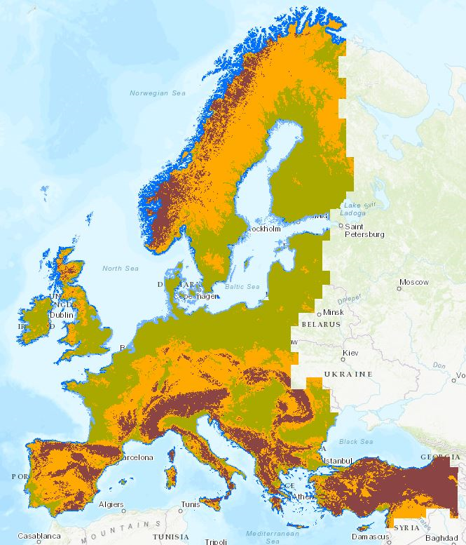
Elevation Breakdown based on EU-DEM (resolution 100m), Dec. 2016
This layer defines homogeneous areas as function of height, slope and distance to the sea. The Elevation Breakdown is used to allocate Land Cover Changes into homogeneous areas as function of height, slope and distance to the sea. It defines five relief typologies: 1) Low coasts, 2) High Coasts, 3) Inlands, 4) Uplands and 4) Mountains. The previous enumeration corresponds to values in the grid.This layer is an updated version using similar methodology to the one created on 2006 (same classes and thresholds) but it has been generated using up-to-date high resolution datasets (EU-DEM) in order to create a more accurate layer.
Simple
Identification info
- Date (Publication)
- 2016-12-20
- Date (Creation)
- 2016-12-20
- Citation identifier
- eea_r_3035_100_m_ebk-eudem_p_2012_v02_r00
- Status
- Obsolete
- Point of contact
-
Organisation Individual Electronic mail address Website Role European Environment Agency
Point of contact
- Spatial representation type
- Grid
Spatial resolution
- Spatial resolution
- 100 m
- Topic category
-
- Elevation
Extent
))
Extent
Temporal extent
- Time period
- 2012-01-01 2012-12-31
- Maintenance and update frequency
- Not planned
- Continents, countries, sea regions of the world.
-
-
EEA32 (2006-2013)
-
Resource constraints
- Use constraints
- Other restrictions
- Other constraints
-
License CC-BY 4.0 ( https://creativecommons.org/licenses/by/4.0/). Copyright holder: European Environment Agency (EEA).
Resource constraints
- Access constraints
- Other restrictions
- Other constraints
- no limitations to public access
- Language
- English
- Character encoding
- UTF8
Distribution Information
- Distribution format
-
-
GeoTIFF
-
- OnLine resource
-
https://sdi.eea.europa.eu/webdav/datastore/public/eea_r_3035_100_m_ebk-eudem_p_2012_v02_r00/
- OnLine resource
-
Elevation Breakdown 2012 100m - Based on EU-DEM (0)
Elevation Breakdown 2012 100m - Based on EU-DEM
- OnLine resource
-
Direct download
- OnLine resource
-
0
Elevation Breakdown 2012 100m - Based on EU-DEM
- OnLine resource
-
Elevation Breakdown calculation
Data quality info
- Hierarchy level
- Dataset
Report
Result
- Title
- Commission Regulation (EU) No 1089/2010 of 23 November 2010 implementing Directive 2007/2/EC of the European Parliament and of the Council as regards interoperability of spatial data sets and services
- Date (Publication)
- 2010-12-08
- Explanation
-
See the referenced specification
Resource lineage
- Statement
-
This version of the Elevation Breakdown was created as an update using the Digital Elevation Model over Europe from the GSGRDA project (EU-DEM, resolution 25 m). Areas next to the sea (<10 km from the coastline) were considered Coasts and splited in two categories: Low coasts (< 50 m) and High coasts (> 50 m). Inlands were the areas between 0 and 200 m outside the coastal strip. Uplands were the zones between 200 - 500 m plus the flat areas between 500 and 1000. The slopy areas between 500 and 1000 m and all the areas over 1000 m were classified as Mountains.
Input layers include:
- EUDEM resampled to 100m (derived from EU-DEM 25m)
- Coastline and reference mask, provided by GISAT.
Detailed methodology is available on http://forum.eionet.europa.eu/etc-sia-consortium/library/2012_subvention/261_2_ludc/133_elevation_data/elevation-breakdown-final-report-1 (section 2).
- Hierarchy level
- Dataset
Reference System Information
Reference System Information
- Code
- EPSG:3035
Metadata
- Metadata identifier
- 0c1a7253-a6d5-43d2-8eb7-49836b11ce53
- Language
- English
- Character encoding
- UTF8
- Contact
-
Organisation Individual Electronic mail address Website Role European Environment Agency
Point of contact
Type of resource
- Resource type
- Dataset
- Metadata linkage
-
https://sdi.eea.europa.eu/catalogue/srv/api/records/0c1a7253-a6d5-43d2-8eb7-49836b11ce53
- Date info (Creation)
- 2018-03-07T13:11:02Z
- Date info (Revision)
- 2025-10-09T10:36:15.317705Z
Metadata standard
- Title
-
ISO 19115/19139
- Edition
-
1.0
)))