 EEA geospatial data catalogue
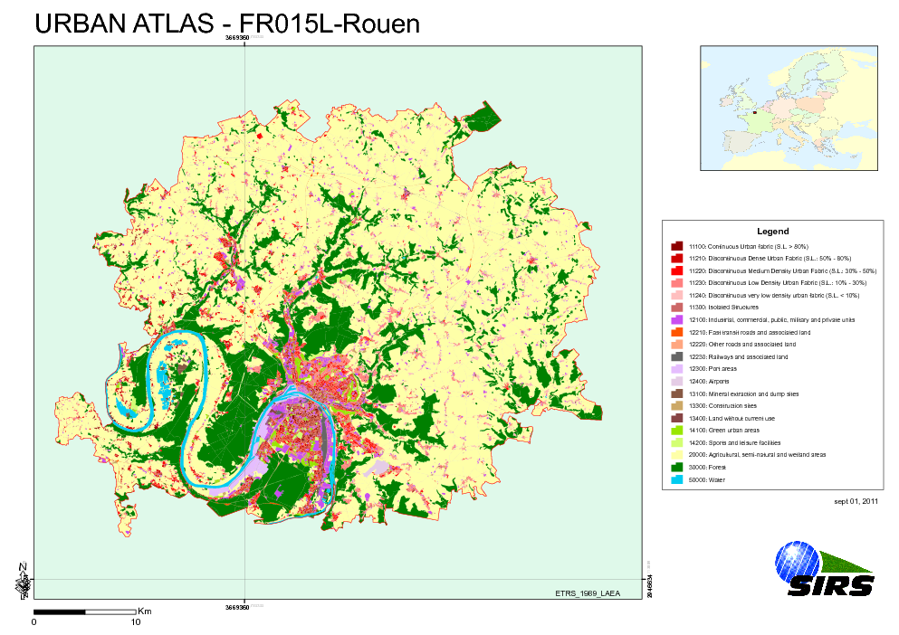
Urban Atlas - France - Rouen
The Urban Atlas is providing pan-European comparable land use and land cover data for Large Urban Zones with more than 100.000 inhabitants as defined by the Urban Audit. Urban Atlas' mission is to provide high-resolution hotspot mapping of changes in urban spaces and indicators for users such as city governments, the European Environment Agency (EEA) and European Commission departments.
Simple
- Date (Publication)
- 2010-05-28
- Date (Creation)
- 2010-05-28
- Citation identifier
- regio_v_32631_10_k_ua-fr015l_p_2005-2009_v01_r00
- Status
- Obsolete
- Point of contact
-
Organisation name Individual name Electronic mail address Website Role European Environment Agency
http://www.eea.europa.eu Point of contact
- GEMET - INSPIRE themes, version 1.0
-
-
Land use
-
-
GEMET
-
-
urban area
-
land use
-
- Keywords
-
- Keywords
-
- Place
-
-
France
-
Rouen
-
-
EEA topics
-
-
Land use
-
- Use limitation
-
EEA standard re-use policy: unless otherwise indicated, re-use of content on the EEA website for commercial or non-commercial purposes is permitted free of charge, provided that the source is acknowledged ( http://www.eea.europa.eu/legal/copyright). Copyright holder: Directorate-General Enterprise and Industry.
- Access constraints
- Other restrictions
- Other constraints
- no limitations to public access
- Spatial representation type
- Vector
- Denominator
- 10000
- Language of dataset
- English
- Character set
- UTF8
- Topic category
-
- Society
))
- Begin date
- 2005-05-27
- End date
- 2009-07-01
- Reference system identifier
- OGP Surveying & Positioning Committee / urn:ogc:def:crs:EPSG:7.1:32631
- Distribution format
-
- SHP ( )
- OnLine resource
-
Protocol Linkage Name EEA:FOLDERPATH
https://sdi.eea.europa.eu/webdav/datastore/public/regio_v_32631_10_k_ua-fr015l_p_2005-2009_v01_r00 EEA:DBPG
pg:gis_sdi/urban_atlas.fr015l_rouen WWW:URL
https://sdi.eea.europa.eu/data/16bd8758-e76f-4dfc-bce6-097113e56080 Direct download
- Hierarchy level
- Dataset
Conformance result
- Title
-
Commission Regulation (EU) No 1089/2010 of 23 November 2010 implementing Directive 2007/2/EC of the European Parliament and of the Council as regards interoperability of spatial data sets and services
- Date (Publication)
- 2010-12-08
- Explanation
-
See the referenced specification
- Statement
-
Earth Observation (EO) Data used:
* Spot 5 10 m - 50352490505271123082J3 (XS) (Date: 2005/05/27)
* Spot 5 2,50 m - 50362500510041121141B0 (P) (Date: 2005/10/04)
* ALOS 10 m - AL_AV2_X_20070328_113715_DLR_6249_PRUTM (XS) (Date: 2007/03/28)
* ALOS 10 m - AL_AV2_X_20070328_113723_DLR_6249_PRUTM (XS) (Date: 2007/03/28)
* ALOS 10 m - AL_AV2_X_20080704_105956_DLR_13017_PRUTM (XS) (Date: 2008/07/04)
* ALOS 2,50 m - AL_PSM_P_20070603_110540_DLR_7226_PRUTM (P) (Date: 2007/06/03)
* ALOS 2,50 m - AL_PSM_P_20080217_110143_DLR_11004_PRUTM (P) (Date: 2008/02/17)
* ALOS 2,50 m - AL_PSM_P_20080217_110148_DLR_11004_PRUTM (P) (Date: 2008/02/17)
* ALOS 2,50 m - AL_PSM_P_20080217_110152_DLR_11004_PRUTM (P) (Date: 2008/02/17)
* ALOS 2,50 m - AL_PSM_P_20090406_110356_DLR_17043_PRUTM (P) (Date: 2009/04/06)
* ALOS 2,50 m - AL_PSM_P_20090406_110400_DLR_17043_PRUTM (P) (Date: 2009/04/06)
* ALOS 2,50 m - AL_PSM_P_20090406_110404_DLR_17043_PRUTM (P) (Date: 2009/04/06)
* RapidEye 5 m - 2009-07-01T114645_RE1_3A-NAC_6211765_110270 (XS) (Date: 2009/07/01)
* RapidEye 5 m - 2009-07-01T114646_RE1_3A-NAC_62117652110270 (XS) (Date: 2009/07/01)
* RapidEye 5 m - 2009-07-01T114647_RE1_3A-NAC_6211748_110270 (XS) (Date: 2009/07/01)
* RapidEye 5 m - 2009-07-01T114648_RE1_3A-NAC_6211758_110270 (XS) (Date: 2009/07/01)
* RapidEye 5 m - 2009-07-01T114649_RE1_3A-NAC_6211761_110270 (XS) (Date: 2009/07/01)
* RapidEye 5 m - 2009-07-01T114650_RE1_3A-NAC_6211757_110270 (XS) (Date: 2009/07/01)
* RapidEye 5 m - 2009-07-01T114653_RE1_3A-NAC_6211759_110270 (XS) (Date: 2009/07/01)
* RapidEye 5 m - 2009-07-01T114653_RE1_3A-NAC_6211760_110270 (XS) (Date: 2009/07/01)
Metadata
- File identifier
- 16bd8758-e76f-4dfc-bce6-097113e56080 XML
- Metadata language
- English
- Character set
- UTF8
- Hierarchy level
- Dataset
- Date stamp
- 2020-07-10T17:18:19
- Metadata standard name
-
ISO 19115/19139
- Metadata standard version
-
1.0
- Metadata author
-
Organisation name Individual name Electronic mail address Website Role European Environment Agency
Point of contact
)))