 EEA geospatial data catalogue
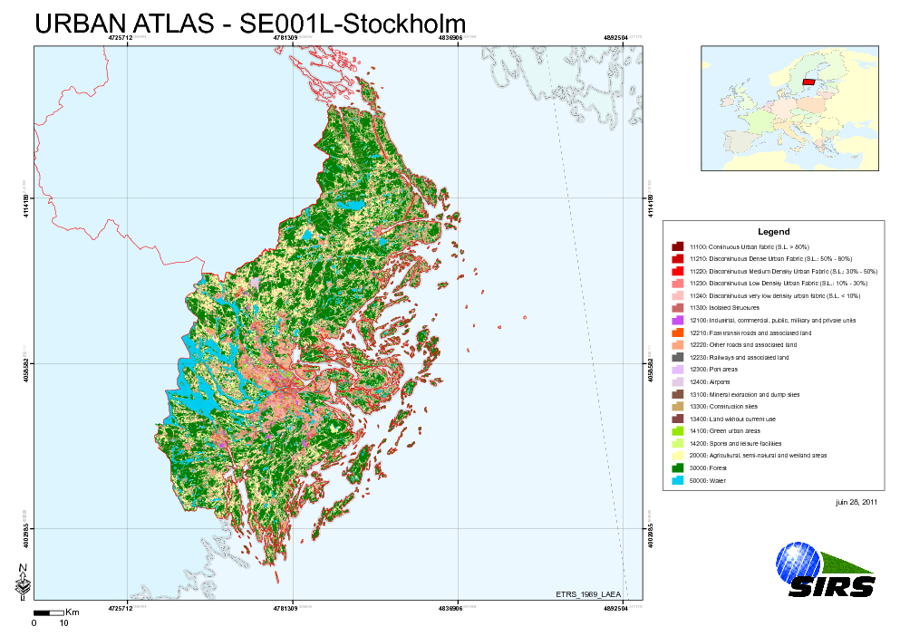
Urban Atlas - Sweden - Stockholm
The Urban Atlas is providing pan-European comparable land use and land cover data for Large Urban Zones with more than 100.000 inhabitants as defined by the Urban Audit. Urban Atlas' mission is to provide high-resolution hotspot mapping of changes in urban spaces and indicators for users such as city governments, the European Environment Agency (EEA) and European Commission departments.
Simple
Identification info
- Date (Publication)
- 2010-05-28
- Date (Creation)
- 2010-05-28
- Citation identifier
- regio_v_32634_10_k_ua-se001l_p_2007-2009_v01_r00
- Status
- Obsolete
- Point of contact
-
Organisation Individual Electronic mail address Website Role European Environment Agency
Point of contact
- Spatial representation type
- Vector
Spatial resolution
Equivalent scale
- Denominator
- 10000
- Topic category
-
- Society
Extent
))
Extent
Temporal extent
- Time period
- 2007-06-09 2009-10-09
- EEA topics
-
-
Sustainability solutions
-
Land use
-
- GEMET - INSPIRE themes, version 1.0
-
-
Land use
-
- GEMET
-
-
urban area
-
land use
-
- Place
-
-
Sweden
-
Stockholm
-
Resource constraints
- Use limitation
-
License CC-BY 4.0 ( https://creativecommons.org/licenses/by/4.0/). Copyright holder: Directorate-General Enterprise and Industry.
Resource constraints
- Access constraints
- Other restrictions
- Other constraints
- no limitations to public access
- Language
- English
- Character encoding
- UTF8
Data quality info
- Hierarchy level
- Dataset
Report
Result
- Title
-
Commission Regulation (EU) No 1089/2010 of 23 November 2010 implementing Directive 2007/2/EC of the European Parliament and of the Council as regards interoperability of spatial data sets and services
- Date (Publication)
- 2010-12-08
- Explanation
-
See the referenced specification
Resource lineage
- Statement
-
Earth Observation (EO) Data used:
* Spot 5 10 m - 50612280909101039532J0 (XS) (Date: 2009/09/10)
* Spot 5 10 m - 50612290910090942502J0 (XS) (Date: 2009/10/09)
* Spot 5 10 m - 50612300909151044072J0 (XS) (Date: 2009/09/15)
* Spot 5 10 m - 50622270908151039132J9 (XS) (Date: 2009/08/15)
* Spot 5 10 m - 50622290910081002062J0 (XS) (Date: 2009/10/08)
* Spot 5 10 m - 50622300906270940402J0 (XS) (Date: 2009/06/27)
* Spot 5 2,50 m - 50612280909101039512B0 (P) (Date: 2009/09/10)
* Spot 5 2,50 m - 50612290910090942472B0 (P) (Date: 2009/10/09)
* Spot 5 2,50 m - 50612300909151044042B0 (P) (Date: 2009/09/15)
* Spot 5 2,50 m - 50622270908151039102B9 (P) (Date: 2009/08/15)
* Spot 5 2,50 m - 50622290910081002042B0 (P) (Date: 2009/10/08)
* Spot 5 2,50 m - 50622300906270940372B0 (P) (Date: 2009/06/27)
* ALOS 10 m - AL_AV2_X_20070811_101306_DLR_8232_PRUTM (XS) (Date: 2007/08/11)
* ALOS 10 m - AL_AV2_X_20070811_101314_DLR_8232_PRUTM (XS) (Date: 2007/08/11)
* ALOS 10 m - AL_AV2_X_20070811_101322_DLR_8232_PRUTM (XS) (Date: 2007/08/11)
* ALOS 10 m - AL_AV2_X_20080727_100738_DLR_13352_PRUTM (XS) (Date: 2008/07/27)
* ALOS 10 m - AL_AV2_X_20080727_100746_DLR_13352_PRUTM (XS) (Date: 2008/07/27)
* ALOS 10 m - AL_AV2_X_20080727_100755_DLR_13352_PRUTM (XS) (Date: 2008/07/27)
* ALOS 10 m - AL_AV2_X_20080727_100803_DLR_13352_PRUTM (XS) (Date: 2008/07/27)
* ALOS 2,50 m - AL_PSM_P_20070609_101103_DLR_7313_PRUTM (P) (Date: 2007/06/09)
* ALOS 2,50 m - AL_PSM_P_20070609_101107_DLR_7313_PRUTM (P) (Date: 2007/06/09)
* ALOS 2,50 m - AL_PSM_P_20070609_101112_DLR_7313_PRUTM (P) (Date: 2007/06/09)
* ALOS 2,50 m - AL_PSM_P_20070609_101116_DLR_7313_PRUTM (P) (Date: 2007/06/09)
* ALOS 2,50 m - AL_PSM_P_20070609_101124_DLR_7313_PRUTM (P) (Date: 2007/06/09)
* ALOS 2,50 m - AL_PSM_P_20080530_101205_DLR_12506_PRUTM (P) (Date: 2008/05/30)
* ALOS 2,50 m - AL_PSM_P_20080530_101209_DLR_12506_PRUTM (P) (Date: 2008/05/30)
* ALOS 2,50 m - AL_PSM_P_20080710_100543_DLR_13104_PRUTM (P) (Date: 2008/07/10)
* ALOS 2,50 m - AL_PSM_P_20080710_100547_DLR_13104_PRUTM (P) (Date: 2008/07/10)
* ALOS 2,50 m - AL_PSM_P_20090417_101609_DLR_17203_PRUTM (P) (Date: 2009/04/17)
* ALOS 2,50 m - AL_PSM_P_20090417_101613_DLR_17203_PRUTM (P) (Date: 2009/04/17)
* ALOS 2,50 m - AL_PSM_P_20090417_101617_DLR_17203_PRUTM (P) (Date: 2009/04/17)
- Hierarchy level
- Dataset
Reference System Information
- Reference system identifier
- OGP Surveying & Positioning Committee/urn:ogc:def:crs:EPSG:7.1:32634
Metadata
- Metadata identifier
- 2227d13e-ff88-4c78-ba05-a77dcb237471
- Language
- English
- Character encoding
- UTF8
- Contact
-
Organisation Individual Electronic mail address Website Role European Environment Agency
Point of contact
Type of resource
- Resource type
- Dataset
- Metadata linkage
-
https://sdi.eea.europa.eu/geonetwork/srv/api/records/2227d13e-ff88-4c78-ba05-a77dcb237471
- Date info (Creation)
- 2012-01-31T13:32:27Z
- Date info (Revision)
- 2025-10-09T10:40:36.296435Z
Metadata standard
- Title
-
ISO 19115/19139
- Edition
-
1.0
)))