 EEA geospatial data catalogue
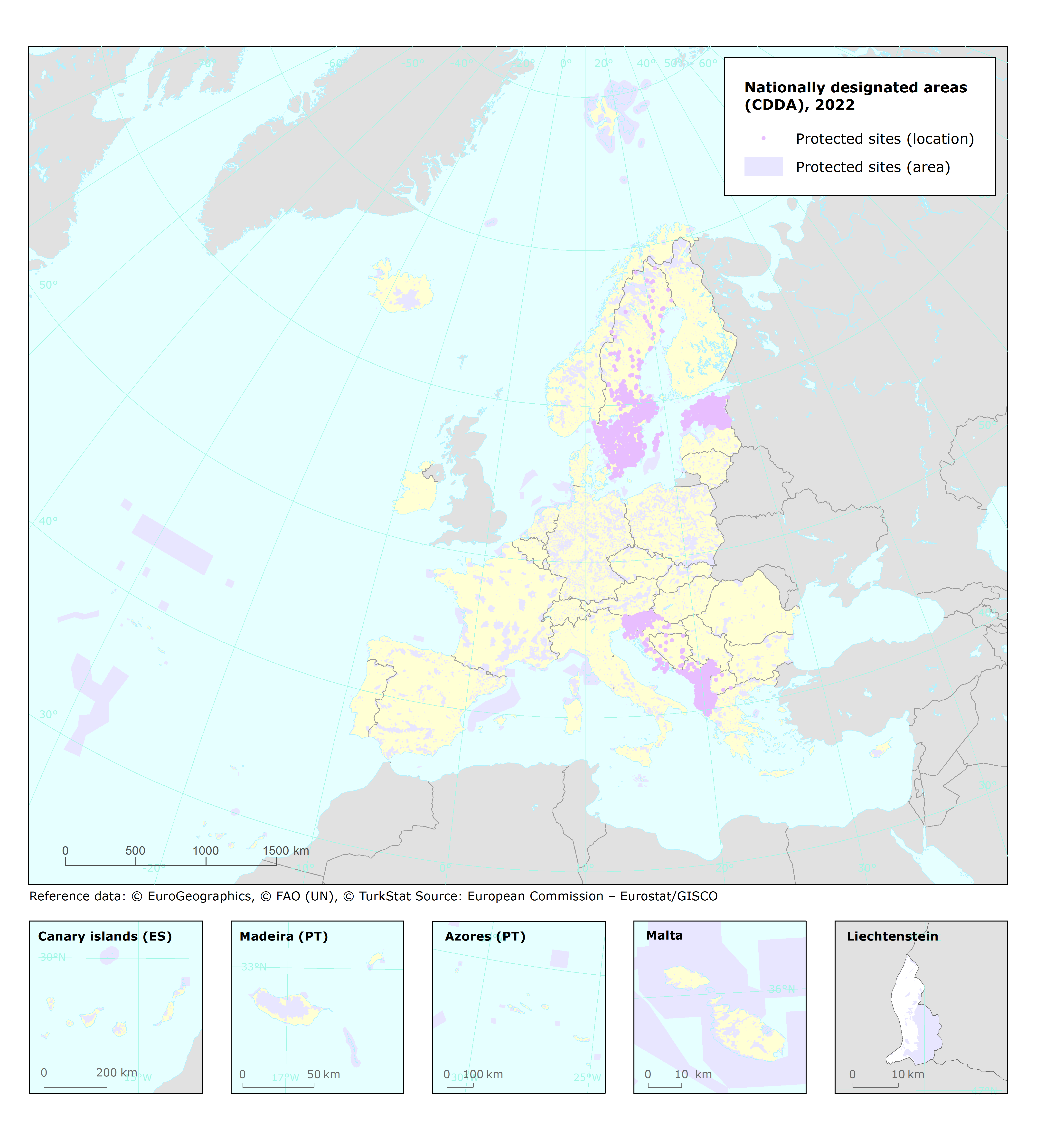
Nationally designated areas for public access - version 20, Jun. 2022
The European inventory of Nationally designated areas (CDDA) holds information about designated areas and their designation types, which directly or indirectly create protected areas. The data is delivered by the Eionet partnership countries as spatial and tabular information.
The inventory began in 1995 under the CORINE programme of the European Commission. The CDDA is now an agreed annual Eionet core data flow maintained by the European Environment Agency (EEA) with support from the European Topic Centre on Biological Diversity (ETC/BD). The dataset is used by the EEA and e.g. the UNEP-WCMC for their main European and global assessments, products and services.
The CDDA is the official source of protected area information from the 38 European* countries to the World Database of Protected Areas (WDPA). The CDDA data can be queried online in the European Nature Information System (EUNIS).
This metadata refers to the public version of the CDDA dataset version 20 (2022). The internal version of this dataset "Nationally designated areas (CDDA) for internal use - version 20, Jun. 2022", from which is derived from this dataset, contains all designated areas and its access is restricted. EEA does not have permission to distribute some or all sites reported by Estonia, Ireland and Türkiye.
Two versions of the dataset are provided. The full dataset ("CDDA_2022_v01_public") includes the entire geographical coverage including nationally designated areas in overseas entities. The "CDDA_2022_v01_public_EuropeEPSG3035" version includes only continental Europe, i.e. excludes the overseas entities. Both versions are provided in GDB and GPKG formats.
The dataset is accompanied by the following tabular data: CDDA_2022_v01_public_DesignatedArea.csv, which includes information on the nationally designated sites and designated boundaries for public dissemination; and CDDA_2022_v01_public_DesignationType.csv, which contains information about designation types and the national and international legislative instruments, which directly or indirectly create protected designated areas in Europe.
* Including Kosovo (UNSCR 1244/99), which designation is without prejudice to positions on status, and is in line with UNSCR 1244 and the ICJ Opinion on the Kosovo Declaration of Independence.
Simple
Identification info
- Date (Publication)
- 2022-06-21
- Date (Creation)
- 2022-06-14
- Edition
-
20.00
- Citation identifier
- eea_v_3035_100_k_cdda-poly_p_2021-2022_v20_r00
- Status
- Superseded
- Point of contact
-
Organisation Individual Electronic mail address Website Role European Environment Agency
Point of contact European Environment Agency
Custodian
- Spatial representation type
- Vector
Spatial resolution
Equivalent scale
- Denominator
- 100000
- Topic category
-
- Environment
Extent
))
Extent
Temporal extent
- Time period
- 2021-01-01 2022-03-15
- Maintenance and update frequency
- Annually
- Continents, countries, sea regions of the world.
-
-
North Macedonia
-
EFTA4
-
Kosovo (UNSCR 1244/99)
-
Bosnia and Herzegovina
-
Serbia
-
Albania
-
Montenegro
-
EU27 (from 2020)
-
- INSPIRE priority data set
-
-
Nationally designated areas - CDDA
-
EEA Annual Work Programme
-
Resource constraints
- Access constraints
- Other restrictions
- Other constraints
- no limitations to public access
Resource constraints
- Use constraints
- Other restrictions
- Other constraints
-
License CC-BY 4.0 ( https://creativecommons.org/licenses/by/4.0/). Copyright holder: European Environment Agency (EEA); Estonian Environmental Register 01.01.2021; Land Burgenland, Land Kärnten, Land Niederösterreich, Land Oberösterreich, Land Salzburg, Land Steiermark, Land Tirol, Land Vorarlberg, Stadt Wien aggregated by Austrian Environment Agency.
Associated resource
- Association Type
- Revision Of
- Metadata Reference
Associated resource
- Association Type
- source
- Metadata Reference
- Language
- English
Content Information
- Feature catalogue citation
Distribution Information
- Distribution format
-
-
GDB
-
Geopackage
-
ascii (.csv, .txt, .sql)
-
- OnLine resource
-
https://sdi.eea.europa.eu/webdav/datastore/public/eea_v_3035_100_k_cdda-poly_p_2021-2022_v20_r00
- OnLine resource
-
Direct download
Data quality info
- Hierarchy level
- Dataset
Report
Result
- Title
- Commission Regulation (EU) No 1089/2010 of 23 November 2010 implementing Directive 2007/2/EC of the European Parliament and of the Council as regards interoperability of spatial data sets and services
- Date (Publication)
- 2010-12-08
- Explanation
-
See the referenced specification
Resource lineage
- Statement
-
The data sources for this dataset are data deliveries from the Eionet, the partnership network of the EEA and its 38 member and cooperating countries. In EU Member States the implementation of INSPIRE Directive may mean that the spatial information is provided via the national or sub-national INSPIRE data providers.
The reference data used in the validation process is the EBM 2020, Jan. 2020 ( https://sdi.eea.europa.eu/catalogue/srv/eng/catalog.search#/metadata/3275ecdb-a6c5-4ffe-875f-c0b2bfcc5786).
The dataset is accompanied with a series of files and documents for download: CDDA_2022_v01_public_DesignatedArea.csv, which includes information on the nationally designated sites and designated boundaries for public dissemination; CDDA_2022_v01_public_DesignationType.csv, which contains information about designation types and the national and international legislative instruments, which directly or indirectly create protected designated areas in Europe.
- Hierarchy level
- Dataset
Reference System Information
Reference System Information
- Code
- EPSG:4326
Reference System Information
Reference System Information
- Code
- EPSG:3035
Metadata
- Metadata identifier
- 28a5cf37-95d5-4758-9204-9eada51ebb8a
- Language
- English
- Character encoding
- UTF8
- Contact
-
Organisation Individual Electronic mail address Website Role European Environment Agency
Point of contact
Type of resource
- Resource type
- Dataset
- Metadata linkage
-
https://sdi.eea.europa.eu/catalogue/srv/api/records/28a5cf37-95d5-4758-9204-9eada51ebb8a
- Date info (Creation)
- 2022-06-30T08:09:09.573Z
- Date info (Revision)
- 2026-02-04T14:06:45.591572Z
Metadata standard
- Title
-
ISO 19115/19139
- Edition
-
1.0
)))