 EEA geospatial data catalogue
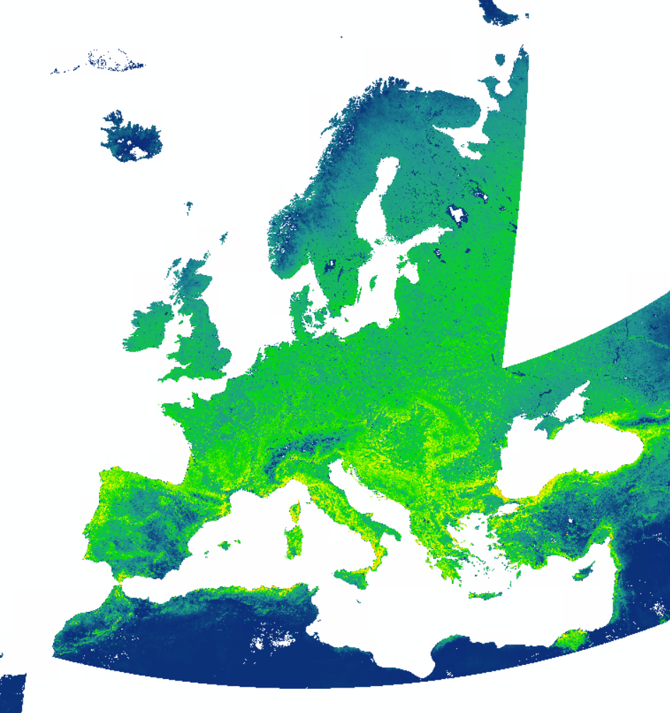
Medium Resolution Net Primary Production (NPP, raster 196m) version 1, Nov. 2023
This metadata refers to the medium resolution yearly Net Primary Production (NPP) dataset
Net Primary Production (NPP) quantifies the the total amount of carbon dioxide used for plant growth per unit time.
The NPP dataset is made available as raster files with 196 x 196m resolution, in European LAEA (EPSG: 3035) projection that cover the EEA38 countries and the United Kingdom and for the period from January 2000 until today, in a yearly interval.
Unit: g C/m²/year (warning, a scaling factor of 100 was applied to the data and values should be divided by 100 to get the correct unit).
Simple
Identification info
- Date (Publication)
- 2023-12-15
- Date (Creation)
- 2023-12-01
- Edition
-
01.00
- Citation identifier
- eea_r_3035_196_m_modis-npp_p_2000-2022_v01_r00
Identifier
- Point of contact
-
Organisation Individual Electronic mail address Website Role European Environment Agency
Distributor European Environment Agency
Custodian European Environment Agency
Point of contact
- Spatial representation type
- Grid
Spatial resolution
- Spatial resolution
- 196 m
- Topic category
-
- Environment
- Imagery base maps earth cover
- Climatology, meteorology, atmosphere
- Geoscientific information
Extent
))
Extent
Temporal extent
- Time period
- 2000-01-01 2022-12-31
- Maintenance and update frequency
- Not planned
- GEMET
-
-
photosynthesis
-
plant production
-
vegetation
-
plant ecology
-
remote sensing
-
natural resource
-
land
-
- Temporal resolution
-
-
Annually
-
- Continents, countries, sea regions of the world.
-
-
EEA38 (from 2020)
-
United Kingdom
-
- EEA topics
Resource constraints
- Access constraints
- Other restrictions
- Other constraints
- no limitations to public access
Resource constraints
- Use constraints
- Other restrictions
- Other constraints
-
License CC-BY 4.0 ( https://creativecommons.org/licenses/by/4.0/). Copyright holder: European Commission, European Environment Agency (EEA).
Associated resource
- Association Type
- Cross reference
- Metadata Reference
Associated resource
- Association Type
- Cross reference
- Metadata Reference
Associated resource
- Association Type
- Cross reference
- Metadata Reference
Associated resource
- Association Type
- Cross reference
- Metadata Reference
- Language
- English
- Character encoding
- UTF8
Data quality info
- Hierarchy level
- Dataset
Report
Result
- Date (Publication)
- 2010-12-08
- Explanation
-
See the referenced specification
Resource lineage
- Statement
-
The basic input data for the GPP calculation are the Terra (MOD) and Aqua (MYD) Moderate Resolution Imaging Spectroradiometer (MODIS) Normalized Difference Vegetation Index (NDVI) (MOD13Q1* / MYD13Q1**) Version 6.1 data. These level 3 data are generated every 16 days at 250 meter (m) spatial. Pre-processing was done by implementing the MODIS pixel reliability layer. Pixels classified as good data and marginal data were retained. The remaining data were further smoothed and gap filled using a Whitakker smoother to daily data. The smoothed and gap filled NDVI is used to calculate fAPAR (Fraction of Absorbed Photosynthetically Active Radiation).
Meteo data were obtained from the Copernicus Climate Change Service AgERA5*** dataset hosted on the VITO TerraScope platform. These data are inferred from the ECMWF ERA5 dataset and improved in terms of spatial resolution and re-gridding. The gridded data is available daily at 0.1° resolution. Details of the dataset can be found here: Agrometeorological indicators from 1979 to present derived from reanalysis (AgERA5). From these data, the “Solar radiation flux [J m-2 day-1]”, “2m temperature” – both daily minimum and maximum were extracted as model driving forces data for the GPP modelling.
GPP is calculated using the the Copernicus Dry Matter Production algorithm (DMP - Swinnen, Tote & Van Hoolst (2021)). This DMP model expresses GPP as the product of the incoming photosynthetically active radiation (PAR), the fraction of PAR absorbed by plants (fAPAR), the maximum LUE, and environmental stress factors (temperature and atmospheric carbon dioxide). For this dataset, the LUE parameter is calibrated on ICOS sites specifically for Europe. GPP is calculated at a decadal scale. Yearly GPP values are retrieved by summing the decadal GPP values and assuming 10 days in each decade.
The yearly NPP product (g C/m²/year) is calculated from yearly GPP product multiplied with a Carbon Use Efficiency (CUE) factor of 0.5.
Raster content: The physical values (PV, expressed in g C/m²/year) are derived from the digital number (DN) using the relation: PV = Scaling * DN, with scaling equal to 0.01
*) MOD13Q1: https://lpdaac.usgs.gov/products/mod13q1v061/
**) MYD13Q1: https://lpdaac.usgs.gov/products/myd13q1v061/
***) AgERA5: https://cds.climate.copernicus.eu/cdsapp#!/dataset/sis-agrometeorological-indicators?tab=overview
Due to the large differences between the GPPmax and FAPAR resolutions, an initial smoothing process of the GPPmax layer has been performed to avoid stripe artifacts. A convolutional smoothing process with 30x30 kernel size has been applied.
Swinnen, E., Toté, C. Van Hoolst, R. 2023. Copernicus Global Land Operations "Vegetation and Energy". Algorithm Theoretical Basis Document. Dry Matter Production (DMP). Gross Dry Matter Production (GDMP). Net Primary Production (NPP). Gross Primary Production (GPP). Collection 300M. Version 1.1.
- Hierarchy level
- Dataset
Reference System Information
Reference System Information
- Code
- EPSG:3035
Metadata
- Metadata identifier
- 28d6b823-e2fd-4bf4-a6aa-cb6a359c52da
- Language
- English
- Character encoding
- UTF8
- Contact
-
Organisation Individual Electronic mail address Website Role European Environment Agency
Point of contact
Type of resource
- Resource type
- Dataset
- Date info (Creation)
- 2023-12-05T12:33:49.173Z
- Date info (Revision)
- 2025-10-09T10:42:09.610782Z
Metadata standard
- Title
-
ISO 19115/19139
- Edition
-
1.0
)))