 EEA geospatial data catalogue
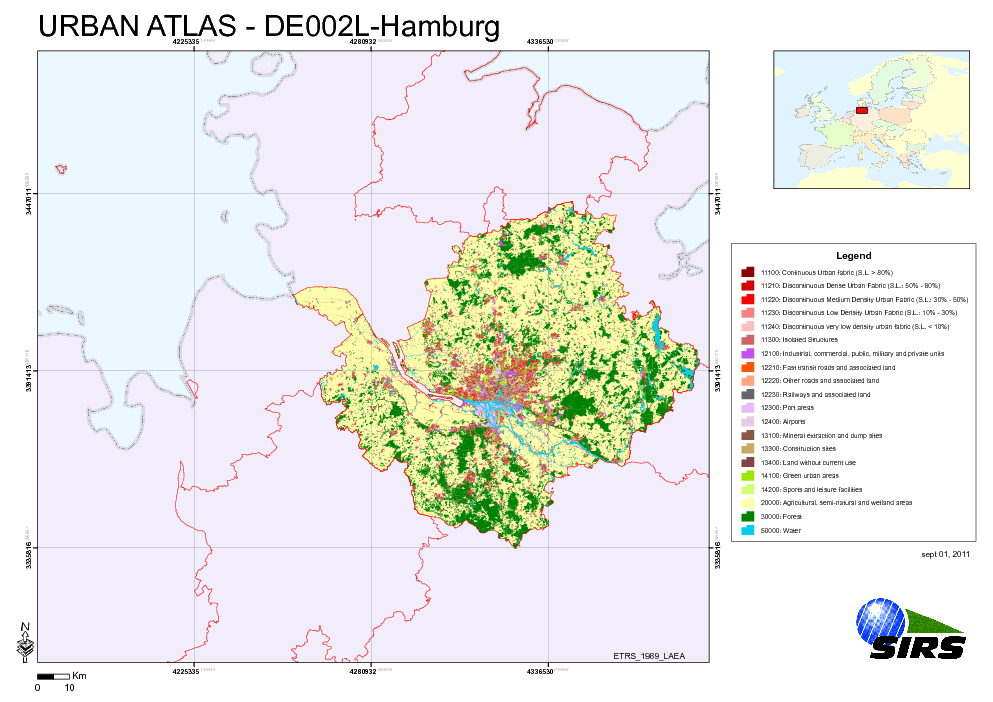
Urban Atlas - Germany - Hamburg
The Urban Atlas is providing pan-European comparable land use and land cover data for Large Urban Zones with more than 100.000 inhabitants as defined by the Urban Audit. Urban Atlas' mission is to provide high-resolution hotspot mapping of changes in urban spaces and indicators for users such as city governments, the European Environment Agency (EEA) and European Commission departments.
Simple
- Date (Publication)
- 2010-05-28
- Date (Creation)
- 2010-05-28
- Citation identifier
- regio_v_32632_10_k_ua-de002l_p_2009-2010_v01_r00
- Status
- Obsolete
- Point of contact
-
Organisation name Individual name Electronic mail address Website Role European Environment Agency
http://www.eea.europa.eu Point of contact
- EEA topics
-
-
Sustainability solutions
-
Land use
-
- GEMET - INSPIRE themes, version 1.0
-
-
Land use
-
-
GEMET
-
-
urban area
-
land use
-
- Keywords
-
- Keywords
-
- Place
-
-
Germany
-
Hamburg
-
- Use limitation
-
EEA standard re-use policy: unless otherwise indicated, re-use of content on the EEA website for commercial or non-commercial purposes is permitted free of charge, provided that the source is acknowledged ( http://www.eea.europa.eu/legal/copyright). Copyright holder: Directorate-General Enterprise and Industry.
- Access constraints
- Other restrictions
- Other constraints
- no limitations to public access
- Spatial representation type
- Vector
- Denominator
- 10000
- Language of dataset
- English
- Character set
- UTF8
- Topic category
-
- Society
))
- Begin date
- 2009-04-10
- End date
- 2010-06-17
- Reference system identifier
- OGP Surveying & Positioning Committee / urn:ogc:def:crs:EPSG:7.1:32632
- Distribution format
-
- SHP ( )
- OnLine resource
-
Protocol Linkage Name EEA:FOLDERPATH
https://sdi.eea.europa.eu/webdav/datastore/public/regio_v_32632_10_k_ua-de002l_p_2009-2010_v01_r00 EEA:DBPG
pg:gis_sdi/urban_atlas.de002l_hamburg WWW:URL
https://sdi.eea.europa.eu/data/3ca25f74-6581-4ca8-a456-21edbae50248 Direct download
- Hierarchy level
- Dataset
Conformance result
- Title
-
Commission Regulation (EU) No 1089/2010 of 23 November 2010 implementing Directive 2007/2/EC of the European Parliament and of the Council as regards interoperability of spatial data sets and services
- Date (Publication)
- 2010-12-08
- Explanation
-
See the referenced specification
- Statement
-
Earth Observation (EO) Data used:
* Spot 5 2,50 m - 50492401006171100402B8 (PS) (Date: 2010/06/17)
* Spot 5 2,50 m - 50502400908201045112B0 (PS) (Date: 2009/08/20)
* Spot 5 2,50 m - 50502410908201045192B0 (PS) (Date: 2009/08/20)
* Spot 5 2,50 m - 50502420908201045272B0 (PS) (Date: 2009/08/20)
* Spot 5 2,50 m - 50532410909011014392B0 (PS) (Date: 2009/09/01)
* Spot 5 2,50 m - 50532420909011014472B0 (PS) (Date: 2009/09/01)
* RapidEye 5 m - 2009-04-10T110514_RE2_3A-NAC_6212971_110437 (XS) (Date: 2009/04/10)
* RapidEye 5 m - 2009-04-18T111046_RE5_3A-NAC_6212756_110437 (XS) (Date: 2009/04/18)
* RapidEye 5 m - 2009-04-18T111047_RE5_3A-NAC_6212766_110437 (XS) (Date: 2009/04/18)
* RapidEye 5 m - 2009-04-18T111049_RE5_3A-NAC_6212773_110437 (XS) (Date: 2009/04/18)
* RapidEye 5 m - 2009-04-18T111050_RE5_3A-NAC_6212700_110437 (XS) (Date: 2009/04/18)
* RapidEye 5 m - 2009-04-18T111050_RE5_3A-NAC_6212763_110437 (XS) (Date: 2009/04/18)
* RapidEye 5 m - 2009-04-18T111052_RE5_3A-NAC_6212771_110437 (XS) (Date: 2009/04/18)
* RapidEye 5 m - 2009-04-18T111053_RE5_3A-NAC_6212699_110437 (XS) (Date: 2009/04/18)
* RapidEye 5 m - 2009-04-19T111354_RE1_3A-NAC_6213203_110437 (XS) (Date: 2009/04/19)
* RapidEye 5 m - 2009-04-19T111358_RE1_3A-NAC_6213202_110437 (XS) (Date: 2009/04/19)
* RapidEye 5 m - 2009-05-13T111747_RE1_3A-NAC_6212970_110437 (XS) (Date: 2009/05/29)
* RapidEye 5 m - 2009-05-29T111207_RE3_3A-NAC_6212767_110437 (XS) (Date: 2009/05/29)
* RapidEye 5 m - 2009-05-29T111211_RE3_3A-NAC_6212758_110437 (XS) (Date: 2009/05/29)
* RapidEye 5 m - 2009-05-29T111213_RE3_3A-NAC_6212760_110437 (XS) (Date: 2009/05/29)
* RapidEye 5 m - 2009-05-29T111214_RE3_3A-NAC_6212768_110437 (XS) (Date: 2009/05/29)
* RapidEye 5 m - 2009-05-29T111217_RE3_3A-NAC_6212757_110437 (XS) (Date: 2009/05/29)
* RapidEye 5 m - 2009-05-29T111221_RE3_3A-NAC_6212974_110437 (XS) (Date: 2009/05/29)
* RapidEye 5 m - 2009-05-31T111327_RE5_3A-NAC_6212764_110437 (XS) (Date: 2009/05/31)
* RapidEye 5 m - 2009-05-31T111330_RE5_3A-NAC_6212765_110437 (XS) (Date: 2009/05/31)
* RapidEye 5 m - 2009-05-31T111330_RE5_3A-NAC_6212973_110437 (XS) (Date: 2009/05/31)
* RapidEye 5 m - 2009-07-03T110649_RE5_3A-NAC_6212772_110437 (XS) (Date: 2009/07/03)
* RapidEye 5 m - 2009-07-03T110652_RE5_3A-NAC_6212769_110437 (XS) (Date: 2009/07/03)
* RapidEye 5 m - 2009-07-03T110653_RE5_3A-NAC_6212770_110437 (XS) (Date: 2009/07/03)
* RapidEye 5 m - 2009-07-03T110656_RE5_3A-NAC_6212755_110437 (XS) (Date: 2009/07/03)
* RapidEye 5 m - 2009-07-05T112955_RE1_3A-NAC_6212762_110437 (XS) (Date: 2009/07/05)
* RapidEye 5 m - 2009-07-27T111044_RE5_3A-NAC_6212972_110437 (XS) (Date: 2009/07/27)
Metadata
- File identifier
- 3ca25f74-6581-4ca8-a456-21edbae50248 XML
- Metadata language
- English
- Character set
- UTF8
- Hierarchy level
- Dataset
- Date stamp
- 2020-07-10T17:13:24
- Metadata standard name
-
ISO 19115/19139
- Metadata standard version
-
1.0
- Metadata author
-
Organisation name Individual name Electronic mail address Website Role European Environment Agency
Point of contact
)))