 EEA geospatial data catalogue
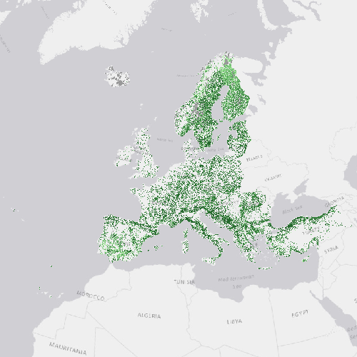
High Resolution Layer: Tree Cover Density 2012 (raster 20m), Mar. 2016
Tree Cover Density (TCD) 2012 is a European mosaic of Tree Cover Density (TCD; 0-100%) in 20m and 100m spatial resolution and European projection. Copernicus Initial Operations 2011-2013 Land Monitoring Services European mosaic of Tree Cover Density (TCD; 0-100%) in 20m and 100m spatial resolution and European projection. The TCD maps the degree (0-100% per pixel) of tree cover density without a minimum mapping unit (MMU), but with a minimum mapping width (MMW) of 20m. The included features are:
1) Evergreen/non-evergreen broad-leaved, sclerophyllous and coniferous trees;
2) Orchards, olive groves, fruit and other tree plantations, agro-forestry areas, forest nurseries, regeneration and transitional woodlands;
3) Alleys, wooded parks and gardens;
4) Groups of trees within urban areas;
5) Forest management/use features inside forests (forest roads, fire-breaks, thinning, etc.) and forest damage features inside forests (partially burnt areas, storm damage, insect-infested damage, etc.) are included if tree cover can be detected from the 20m imagery.
Accordingly, included features are all detectable trees, independent of use. The calibration of the TCD values is being improved as part of the 2015 production, and the 2012 TCD status layer will be updated and replaced by a new version to be published in early 2018 (together with the 2015 status layer, and a new 2012-2015 change product).
The production of the Tree Cover Density (TCD) 2012 was coordinated by the European Environment Agency (EEA) in the frame of the EU Copernicus programme.
Simple
Identification info
- Date (Creation)
- 2016-03-31
- Date (Publication)
- 2016-03-31
- Edition
-
xx.xx
- Citation identifier
- copernicus_r_3035_20_m_tcd-2012_p_2011-2012_vxx_rxx
- Status
- Obsolete
- Point of contact
-
Organisation Individual Electronic mail address Website Role European Commission
Owner Copernicus Land Monitoring Service
Custodian European Environment Agency
Publisher Copernicus Land Monitoring Service helpdesk
Point of contact
- Spatial representation type
- Grid
Spatial resolution
- Spatial resolution
- 20 m
- Topic category
-
- Environment
- Imagery base maps earth cover
Extent
Temporal extent
- Time period
- 2011-01-01 2012-12-31
Extent
))
))
- Maintenance and update frequency
- Continual
- GEMET - INSPIRE themes, version 1.0
-
-
Land cover
-
- Continents, countries, sea regions of the world.
-
-
EEA39
-
- GEMET
-
-
landscape alteration
-
land use
-
forest management
-
land cover
-
tree
-
- EEA topics
-
-
Land use
-
Resource constraints
- Access constraints
- Other restrictions
- Other constraints
- no limitations to public access
Resource constraints
- Use constraints
- Other restrictions
- Other constraints
-
The Copernicus component is governed by Regulation (EU) No 2021/696 of the European Parliament and of the Council of 28 April 2021 establishing the Union Space Programme and the European Union Agency for the Space Programme and repealing Regulations (EU) No 912/2010, (EU) No 1285/2013 and (EU) No 377/2014 and Decision No 541/2014/EU. Within the Copernicus component, a portfolio of land monitoring activities has been delegated by the European Union to the European Environment Agency (EEA) and the DG Joint Research Centre of the European Commission.
The Copernicus land monitoring products and services are made available on a principle of full, open and free access, as established by the Commission Delegated Regulation (EU) No 1159/2013 of 12 July 2013.
Free, full and open access to the products and services of the Copernicus Land Monitoring Service is made on the conditions that:
1. When distributing or communicating Copernicus Land Monitoring Service products and services (data, software scripts, web services, user and methodological documentation and similar) to the public, users shall inform the public of the source of these products and services.
2. Where the Copernicus Land Monitoring Service products and services have been adapted or modified by the user, the user shall clearly state this.
3. Users shall make sure not to convey the impression to the public that the user's activities are officially endorsed by the European Union.
Associated resource
- Association Type
- Cross reference
- Metadata Reference
- Language
- English
- Character encoding
- UTF8
Distribution Information
- Distribution format
-
-
GeoTIFF
-
- Ordering instructions
-
This dataset is no longer accessible from the website of the Copernicus Land Monitoring Service. You can request access to this dataset by contacting the service desk of the Copernicus Land Monitoring Service at copernicus@eea.europa.eu.
Data quality info
- Hierarchy level
- Dataset
Report
Result
- Title
-
Commission Regulation (EU) No 1089/2010 of 23 November 2010 implementing Directive 2007/2/EC of the European Parliament and of the Council as regards interoperability of spatial data sets and services
- Date (Publication)
- 2010-12-08
- Explanation
-
See the referenced specification
Resource lineage
- Statement
-
The product is derived by semi-automatic classification and computer aided visual refinement, based on ESA provided High Resolution satellite imagery (DWH_M62_CORE_01). The imagery is provided as COV1: mainly IRS RS2 and SPOT 4/5 in 20 and 25m spatial resolution, and as COV2: RapidEye. Step-wise enhancement using CLC2006/CLC2012 and mitigation (cloud-/gap-filling) with additional EO data for the area of the EEA39 (39 member states and affiliated countries to the European Environment Agency) and subsequently final integration to a European mosaic.
- Hierarchy level
- Dataset
Reference System Information
Reference System Information
- Code
- EPSG:3035
- Maintenance and update frequency
Metadata
- Metadata identifier
- 437c4900-f394-454c-81bd-c3f5a7cddddb
- Language
- English
- Character encoding
- UTF8
- Contact
-
Organisation Individual Electronic mail address Website Role European Environment Agency
Point of contact
Type of resource
- Resource type
- Dataset
- Metadata linkage
-
https://sdi.eea.europa.eu/geonetwork/srv/api/records/437c4900-f394-454c-81bd-c3f5a7cddddb
- Date info (Creation)
- 2018-02-16T15:40:36Z
- Date info (Revision)
- 2025-10-09T10:47:26.451417Z
Metadata standard
- Title
-
ISO 19115/19139
- Edition
-
1.0
),POLYGON((44.8212%2034.5619,44.8212%2071.1855,-10.6198%2071.1855,-10.6198%2034.5619,44.8212%2034.5619))))