 EEA geospatial data catalogue
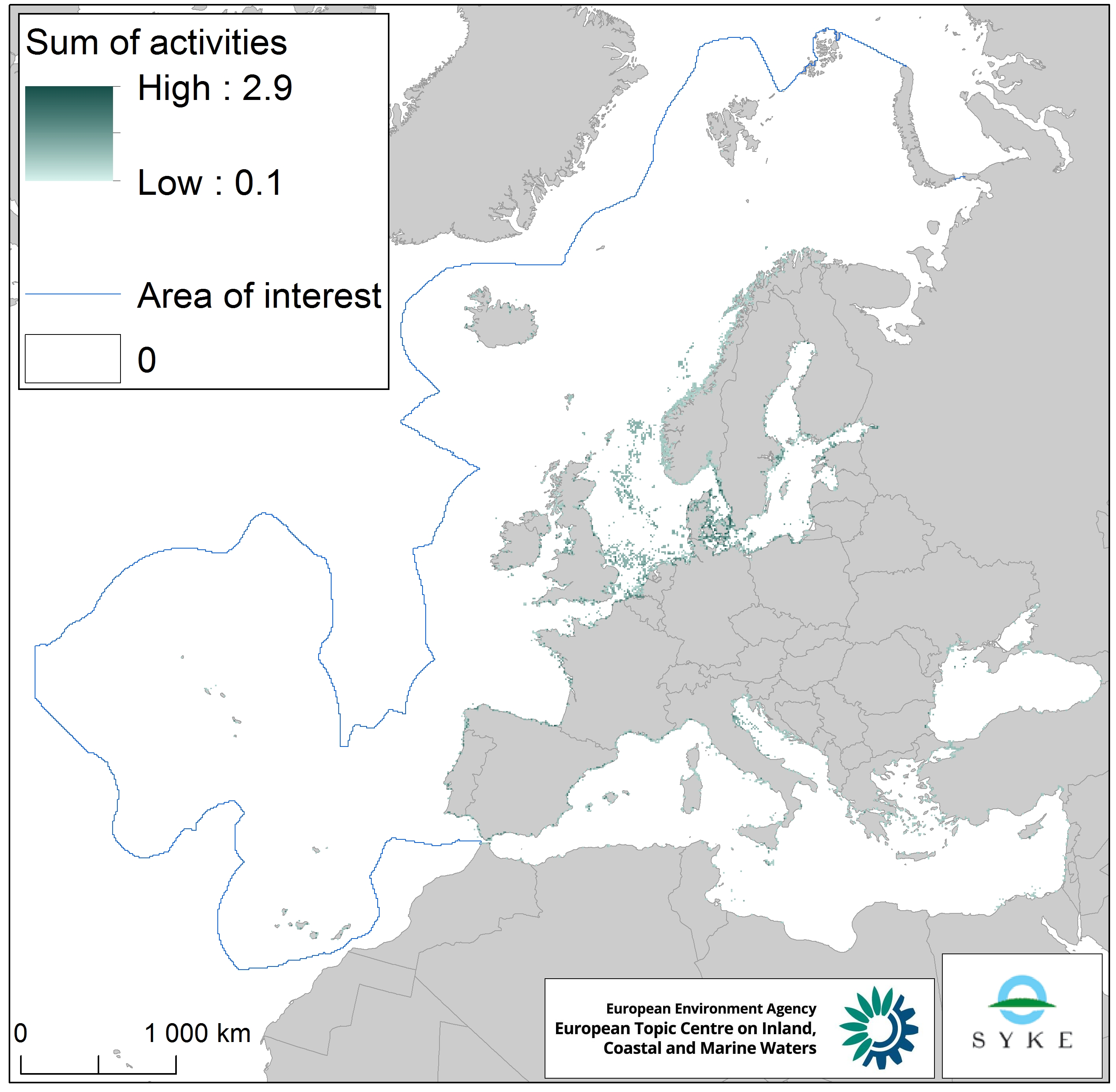
Physical loss to seabed in Europe Seas, Jan. 2020
This raster dataset represents the physical loss of the seabed in the European seas. Physical habitat loss is an extreme pressure on the marine ecosystem which was defined to include all impacts on the seabed which take more than 12 years to recover, a time span influencing even long living marine mammals and seabirds. Habitat is lost if its substrate, morphology or topography is permanently altered.
The dataset is an aggregation of several different human activities that cause physical loss in the seabed: dredging and dumping of dredged material, oil and gas rigs, offshore installations, ports, sand and gravel extraction and windfarms. The resulting dataset is a raster (10km grid cell) derived from EMODnet, MED-IAMER and 4C Offshore datasets and with temporal reference from 2012 to 2017. Higher values mean more loss causing activity in the area. Due to its resolution, loss causing activity in a cell does not usually mean that all the seabed habitat in the area is lost.
This dataset has been prepared for the calculation of the combined effect index, produced for the ETC/ICM Report 4/2019 "Multiple pressures and their combined effects in Europe's seas" available on: https://www.eionet.europa.eu/etcs/etc-icm/etc-icm-report-4-2019-multiple-pressures-and-their-combined-effects-in-europes-seas-1.
Simple
Identification info
- Date (Creation)
- 2019-05-01
- Date (Publication)
- 2020-01-27
- Edition
-
01.00
- Citation identifier
- eea_r_3035_10_km_physical-loss_p_2012-2017_v01_r00
- Point of contact
-
Organisation Individual Electronic mail address Website Role European Environment Agency
Point of contact European Environment Agency
Custodian
- Spatial representation type
- Grid
Spatial resolution
- Spatial resolution
- 10 km
- Topic category
-
- Environment
- Oceans
Extent
))
Temporal extent
- Time period
- 2012-01-01 2017-12-31
Extent
- Maintenance and update frequency
- As needed
- GEMET
-
-
sea bed
-
gravel extraction
-
dredged material
-
fishing
-
pressure
-
harbour
-
loss
-
sea
-
oil extraction
-
sand extraction
-
wind power
-
dredging
-
environmental pressure
-
- Continents, countries, sea regions of the world.
-
-
North Sea
-
Bay of Biscay
-
Norwegian Sea
-
English Channel
-
Northeast Atlantic Ocean (40W)
-
Adriatic Sea
-
Black Sea
-
Iceland Sea
-
Ionian Sea
-
Kattegat
-
Mediterranean Sea
-
Barents Sea
-
Baltic Sea
-
Celtic Sea
-
- Spatial scope
-
-
European
-
- EEA topics
-
-
Biodiversity
-
Fisheries and aquaculture
-
Production and consumption
-
Industry
-
Seas and coasts
-
Resource constraints
- Access constraints
- Other restrictions
- Other constraints
- no limitations to public access
Resource constraints
- Use constraints
- Other restrictions
- Other constraints
-
License CC-BY 4.0 ( https://creativecommons.org/licenses/by/4.0/). Copyright holder: European Environment Agency (EEA).
- Language
- English
Distribution Information
Data quality info
- Hierarchy level
- Dataset
Report
Result
- Title
-
Commission Regulation (EU) No 1089/2010 of 23 November 2010 implementing Directive 2007/2/EC of the European Parliament and of the Council as regards interoperability of spatial data sets and services
- Date (Publication)
- 2010-12-08
- Explanation
-
See the referenced specification
Resource lineage
- Statement
-
The dataset was created by combining 5 different human activities layers:
1. Dredging and dumping of dredged material (EMODnet Human Activities - Dredging: https://www.emodnet-humanactivities.eu/search-results.php?dataname=Dredging, Dumping: https://www.emodnet-humanactivities.eu/search-results.php?dataname=Dredge+Spoil+Dumping+%28Points%29, https://www.emodnet-humanactivities.eu/search-results.php?dataname=Dredge+Spoil+Dumping+%28Polygons%29 )
2. Oil and gas rigs, offshore installations (EMODnet: https://www.emodnet-humanactivities.eu/search-results.php?dataname=Offshore+Installations, MED-IAMER: https://www.msp-platform.eu/projects/med-iamer-integrated-actions-mitigate-environmental-risks-mediterranean-sea)
3. Ports (based on EMODnet vessel density 2017, which metadata is available on: https://www.emodnet-humanactivities.eu/search-results.php?dataname=Vessel+Density+)
4. Sand and gravel extraction (EMODnet Human Activities: https://www.emodnet-humanactivities.eu/search-results.php?dataname=Aggregate+Extraction+Points)
5. Windfarms (4C Offshore database: https://www.4coffshore.com/windfarms/)
All human activities layers were normalized and then summed into one raster. The temporal extent varies between the data sources.
- Hierarchy level
- Dataset
- Source
-
- https://www.emodnet-humanactivities.eu/search-results.php?dataname=Dredging
- https://www.emodnet-humanactivities.eu/search-results.php?dataname=Dredge+Spoil+Dumping+%28Points%29
- https://www.emodnet-humanactivities.eu/search-results.php?dataname=Dredge+Spoil+Dumping+%28Polygons%29
- https://www.emodnet-humanactivities.eu/search-results.php?dataname=Offshore+Installations
- https://www.msp-platform.eu/projects/med-iamer-integrated-actions-mitigate-environmental-risks-mediterranean-sea
- https://www.emodnet-humanactivities.eu/search-results.php?dataname=Vessel+Density+
- https://www.emodnet-humanactivities.eu/search-results.php?dataname=Aggregate+Extraction+Points
Reference System Information
Reference System Information
- Code
- EPSG:3035
Metadata
- Metadata identifier
- 6e2e8ce0-7d81-4904-bf52-e919f784ef6e
- Language
- English
- Character encoding
- UTF8
- Contact
-
Organisation Individual Electronic mail address Website Role European Environment Agency
Point of contact
Type of resource
- Resource type
- Dataset
- Metadata linkage
-
https://sdi.eea.europa.eu/catalogue/srv/api/records/6e2e8ce0-7d81-4904-bf52-e919f784ef6e
- Date info (Creation)
- 2020-07-16T12:20:31Z
- Date info (Revision)
- 2025-10-09T10:56:35.360048Z
Metadata standard
- Title
-
ISO 19115/19139
- Edition
-
1.0
)))