 EEA geospatial data catalogue
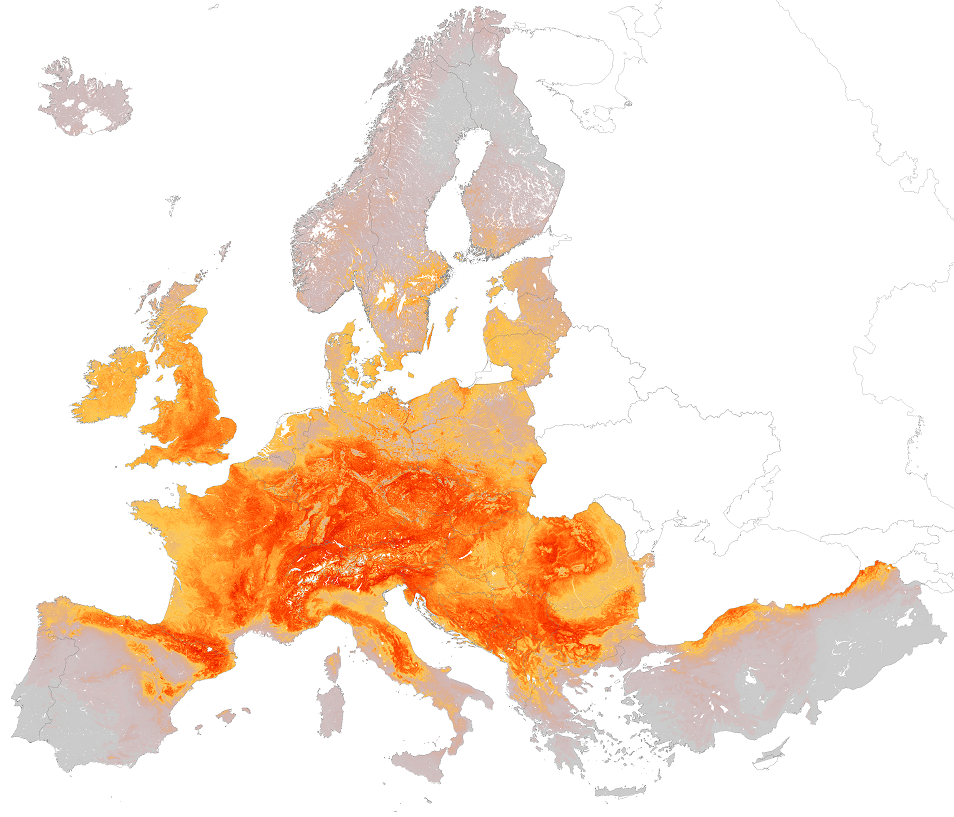
EUNIS grasslands and lands dominated by forbs, mosses or lichens habitat types, predicted distribution of habitat suitability - version 1, Nov. 2021
This metadata corresponds to the EUNIS grasslands and lands dominated by forbs, mosses or lichens habitat types, predicted distribution of habitat suitability dataset.
These habitat types correspond to non-coastal land which is dry or only seasonally wet (with the water table at or above ground level for less than half of the year) with greater than 30% vegetation cover. The vegetation is dominated by grasses and other non-woody plants, including mosses, macrolichens, ferns, sedges and herbs. Includes semiarid steppes with scattered Artemisia scrub. Includes successional weedy vegetation. Excludes regularly tilled habitats (V1) dominated by cultivated herbaceous vegetation such as arable fields and managed grasslands such as recreation fields and lawns.
The modelled suitability for the EUNIS grasslands and lands dominated by forbs, mosses or lichens habitat types is an indication of where conditions are favourable for the habitat type based on sample plot data (Braun-Blanquet database) and the Maxent software package. The modelled suitability map may be used as a proxy for the geographical distribution of the habitat type. Note however that it is not representing the actual distribution of the habitat type. As predictors for the suitabilty modelling not only Climate and Soil parameters have been taken into account, but also so-called RS-EVB's, Remote Sensing-enabled Essential Biodiversity Variables like Landuse, Vegetation height, Phenology, and LAI (Leave Area Index). Because the EBV's are restricted by the extent of the Remote Sensing data (EEA38 countries and the United Kingdom) the modelling result does also not go beyond this boundary. The dataset is provided both in Geodatabase and Geopackage formats.
Simple
Identification info
- Date (Publication)
- 2021-11-15
- Date (Creation)
- 2019-03-01
- Edition
-
01.00
- Citation identifier
- eea_r_3035_1_km_eunis-hab-r_p_1940-2017_v01_r00
- Citation identifier
- DAT-137-en
Identifier
- Point of contact
-
Organisation Individual Electronic mail address Website Role European Environment Agency
Point of contact European Environment Agency
Custodian
- Spatial representation type
- Grid
Spatial resolution
- Spatial resolution
- 1 km
- Topic category
-
- Biota
Extent
))
Extent
Temporal extent
- Time period
- 1940-01-01 2017-12-31
- Maintenance and update frequency
- Not planned
- EEA topics
-
-
Biodiversity
-
- GEMET - INSPIRE themes, version 1.0
-
-
Habitats and biotopes
-
- GEMET
-
-
modelling
-
habitat
-
grassland
-
moss
-
lichen
-
natural area
-
terrestrial ecosystem
-
- Continents, countries, sea regions of the world.
-
-
EEA38 (from 2020)
-
United Kingdom
-
- EEA Management Plan
-
-
2021 1.1.4
-
Resource constraints
- Access constraints
- Other restrictions
- Other constraints
- no limitations to public access
Resource constraints
- Use constraints
- Other restrictions
- Other constraints
-
License CC-BY 4.0 ( https://creativecommons.org/licenses/by/4.0/). Copyright holder: European Environment Agency (EEA).
- Language
- English
Distribution Information
Data quality info
- Hierarchy level
- Dataset
Report
Result
- Title
- Commission Regulation (EU) No 1089/2010 of 23 November 2010 implementing Directive 2007/2/EC of the European Parliament and of the Council as regards interoperability of spatial data sets and services
- Date (Publication)
- 2010-12-08
- Explanation
-
See the referenced specification
Resource lineage
- Statement
-
The database compiled for the Braun-Blanquet project is a compilation of various national and regional vegetation databases. The maintenance of these databases is in principle in the hands of the custodians. However, before uploading the databases into Braun-Blanquet database a quality check is performed by Alterra and Masaryk University. If possible, detected errors are corrected and reported back to the data provider. For the modelling of the habitat suitability map the Maxent software is used ( https://biodiversityinformatics.amnh.org/open_source/maxent/). The grid values in the map represent the probability (ranging from 0-1) that the cell is suitable for the habitat.
The grid file represents the habitat suitability of the EUNIS type. For the modelling the widely used software Maxent for maximum entropy modelling of species’ geographic distributions was used. Maxent is a general-purpose machine-learning method with a simple and precise mathematical formulation, and has a number of aspects that make it well-suited for species distribution modelling when only presence (occurrence) data but not absence data are available (Philips et al. 2006). Because EUNIS habitats have a particular species composition, they are assumed to respond to specific ecological requirements, allowing us to generate correlative estimates of geographic distributions. Modelling habitats that have been floristically defined is a well-known procedure for ecological modelling at local scales, and a promising technique to be applied also at the continental level.
The Maxent method considers presence data (known observations of a given entity) and the so-called background data. Background data comprise a set of points used to describe the environmental variation of the study area according to the available environmental layers. It is assumed that these layers represent well the most important ecological gradients on a European scale. As layers the following environmental parameters have been used: Potential Evapotranspiration, Topsoil pH, Solar radiation, Temperature Seasonality (standard deviation *100), Mean Temperature of Wettest Quarter, Annual Precipitation, Precipitation Seasonality (Coefficient of Variation), Precipitation of Warmest Quarter & Distance to water (rivers, lakes, sea) and the RS-EBV's (Remote Sensing-enabled Essential Biodiversity Variables) Inundation; occurrence, Phenology; End of Season (day number), Phenology; Length of season (days), Phenology; Low of season (day number), Phenology; NDVI mean, Phenology; NDVI seasonality, Phenology; Peak of season (day number), Phenology; Start of Season (day number), Vegetation height (m). For more information on the RS-EBV's see the document "Description of European RS-EBV’sand abiotic site conditions" provided with the dataset.
Supporting information on the creation of this dataset is available in the ETC/BD Technical paper 9/2018: Distribution and habitat suitability maps of revised EUNIS grassland, heathland, scrub, tundra and forest types at: https://www.eionet.europa.eu/etcs/etc-bd/products/etc-bd-reports/maps_revised_eunis_grassland_heath_scrub_tundra_forest.
- Hierarchy level
- Dataset
Reference System Information
Reference System Information
- Code
- EPSG:3035
Metadata
- Metadata identifier
- 70fbb9d1-b61b-4bdc-973b-fec4d8835ccd
- Language
- English
- Character encoding
- UTF8
- Contact
-
Organisation Individual Electronic mail address Website Role European Environment Agency
Point of contact
Type of resource
- Resource type
- Dataset
- Metadata linkage
-
https://sdi.eea.europa.eu/catalogue/srv/api/records/70fbb9d1-b61b-4bdc-973b-fec4d8835ccd
- Date info (Creation)
- 2019-04-25T12:51:27Z
- Date info (Revision)
- 2025-10-09T10:57:11.522147Z
Metadata standard
- Title
-
ISO 19115/19139
- Edition
-
1.0
)))