 EEA geospatial data catalogue
ESDAC Topsoil Soil Organic Carbon (LUCAS) for EU25, Nov. 2014
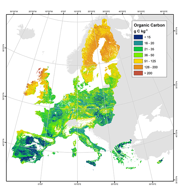
This European Soil Data Centre (ESDAC) dataset provides the maps of Topsoil Soil Organic Carbon in EU-25 (reference year 2014) that are based on LUCAS 2009 soil point data through a generalized additive model. The data provided have been prepared for use by the Land Resource Management Unit (Institute for Environment & Sustainability) of the Joint Research Centre (JRC) of the European Commission.
This metadata refers to two maps:
a) Map of predicted topsoil organic carbon content (g C kg-1) : The map was produced by fitting a generalised additive model between organic carbon measurements from the LUCAS survey (dependent variable) and a set of selected environmental covariates; namely slope, land cover, annual accumulated temperature, net primary productivity, latitude and longitude. The format provided is GeoTIFF.
b) Map of standard error of the OC model predictions (g C kg-1): This map presents the associated uncertainty to the organic carbon content predictions. The standard error, which shows the theoretical range of deviation in the prediction made by the generalized additive model, was calculated for every pixel of the Map of predicted topsoil organic carbon content, based on the posterior covariance matrix of the fitted parameters. The format provided is GeoTIFF.
The map of predicted OC content had the smallest values in Mediterranean countries and in croplands across Europe, whereas largest OC contents were predicted in wetlands, woodlands and mountainous areas. The map of the predictions' standard error had large uncertainty in northern latitudes, wetlands, moors and heathlands, whereas small uncertainty was mostly found in croplands. The map produced gives the most updated general picture of topsoil OC content at the European Union scale.
IMPORTANT NOTE: this metadata is only for internal EEA use. The original metadata of this dataset prepared by ESDAC can be found here: https://esdac.jrc.ec.europa.eu/content/topsoil-soil-organic-carbon-lucas-eu25. For any problem / question / comment on this dataset, please contact ec-esdac@ec.europa.eu .
About ESDAC:
a) Panagos P., Van Liedekerke M., Jones A., Montanarella L., “European Soil Data Centre: Response to European policy support and public data requirements”; (2012) Land Use Policy, 29 (2), pp. 329-338. doi:10.1016/j.landusepol.2011.07.003
b) European Soil Data Centre (ESDAC), esdac.jrc.ec.europa.eu, European Commission, Joint Research Centre
Simple
Identification info
- Date (Creation)
- 2014-10-16
- Date (Publication)
- 2014-10-16
- Edition
-
01.00
- Citation identifier
- jrc_r_3035_500_m_topsoil-oc_i_2014_v01_r00
- Spatial representation type
- Grid
Spatial resolution
- Spatial resolution
- 500 m
- Topic category
-
- Environment
Extent
))
Temporal extent
- Time period
- 2014-01-01 2014-12-31
- Maintenance and update frequency
- Unknown
- GEMET
-
-
soil
-
carbon
-
model
-
land cover
-
organic carbon
-
slope
-
- Continents, countries, sea regions of the world.
-
-
EU25
-
- Spatial scope
-
-
European
-
Resource constraints
- Access constraints
- Other restrictions
- Other constraints
- no limitations to public access
Resource constraints
- Use constraints
- Other restrictions
- Other constraints
-
The dataset has been provided to EEA for internal use and cannot be passed onto third parties. See conditions below:
1) The data provided have been prepared for use by the Land Resource Management Unit (Institute for Environment & Sustainability) of the Joint Research Centre (JRC) of the European Commission.
2) The data are the result of JRC research activities and are primarily made available for further research. The JRC does not accept any liability whatsoever for any error, missing data or omission in the data, or for any loss or damage arising from its use. The JRC agrees to provide the data free of charge but is not bound to justify the content and values contained in the databases.
3) The permission to use the data specified above is granted on condition that, under no circumstances are these data passed to third parties. They can be used for any purpose, including commercial gain.
4) The user agrees to:
a) Make proper reference to the source of the data when disseminating the results to which this agreement relates;
b) Participate in the verification of the data (e.g. by noting and reporting any errors or omissions discovered to the JRC).
- Language
- English
Data quality info
- Hierarchy level
- Dataset
Report
Result
- Title
-
Commission Regulation (EU) No 1089/2010 of 23 November 2010 implementing Directive 2007/2/EC of the European Parliament and of the Council as regards interoperability of spatial data sets and services
- Date (Publication)
- 2010-12-08
- Explanation
-
See the referenced specification
Resource lineage
- Statement
-
For information about the sources used and the generation of the maps:
D. de Brogniez, C. Ballabio, A. Stevens, R. J. A. Jones, L. Montanarella and B. van Wesemael (2014). A map of the topsoil organic carbon content of Europe generated by a generalized additive model. European Journal of Soil Science. 66(1): 121-134 . doi: 10.1111/ejss.12193
About ESDAC:
Panagos P., Van Liedekerke M., Jones A., Montanarella L., “European Soil Data Centre: Response to European policy support and public data requirements”; (2012) Land Use Policy, 29 (2), pp. 329-338. doi:10.1016/j.landusepol.2011.07.003
European Soil Data Centre (ESDAC), esdac.jrc.ec.europa.eu, European Commission, Joint Research Centre
- Hierarchy level
- Dataset
Reference System Information
Reference System Information
- Code
- EPSG:3035
Metadata
- Metadata identifier
- 75033661-550e-4c36-b1b7-b502ec545aa7
- Language
- English
- Character encoding
- UTF8
- Contact
-
Organisation Individual Electronic mail address Website Role European Environment Agency
Point of contact
Type of resource
- Resource type
- Dataset
- Date info (Creation)
- 2021-05-20T08:44:04.94Z
- Date info (Revision)
- 2025-10-09T10:57:57.051372Z
Metadata standard
- Title
-
ISO 19115/19139
- Edition
-
1.0
)))