 EEA geospatial data catalogue
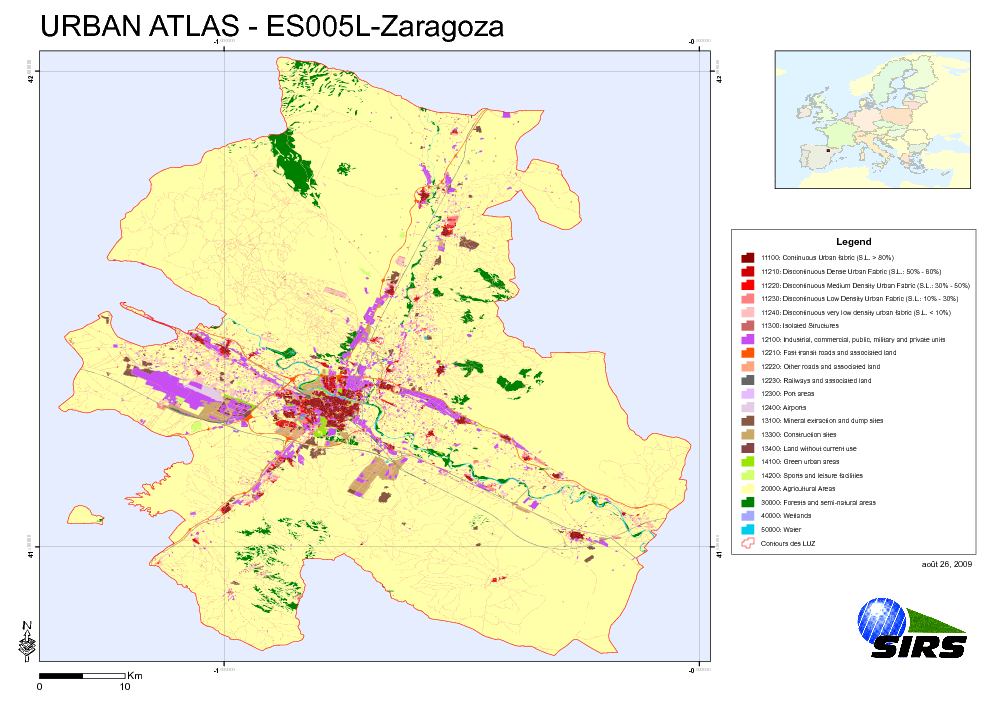
Urban Atlas - Spain - Zaragoza (Zaragosa)
The Urban Atlas is providing pan-European comparable land use and land cover data for Large Urban Zones with more than 100.000 inhabitants as defined by the Urban Audit. Urban Atlas' mission is to provide high-resolution hotspot mapping of changes in urban spaces and indicators for users such as city governments, the European Environment Agency (EEA) and European Commission departments.
Simple
- Date (Publication)
- 2010-05-28
- Date (Creation)
- 2010-05-28
- Citation identifier
- regio_v_32630_10_k_ua-es005l_p_2007-2008_v01_r00
- Status
- Obsolete
- Point of contact
-
Organisation name Individual name Electronic mail address Website Role European Environment Agency
http://www.eea.europa.eu Point of contact
- EEA topics
-
-
Land use
-
Sustainability solutions
-
-
GEMET - INSPIRE themes, version 1.0
-
-
Land use
-
-
GEMET
-
-
urban area
-
land use
-
- Keywords
-
- Keywords
-
- Place
-
-
Spain
-
Zaragoza
-
- Use limitation
-
License CC-BY 4.0 ( https://creativecommons.org/licenses/by/4.0/). Copyright holder: Directorate-General Enterprise and Industry.
- Access constraints
- Other restrictions
- Other constraints
- no limitations to public access
- Spatial representation type
- Vector
- Denominator
- 10000
- Language of dataset
- English
- Character set
- UTF8
- Topic category
-
- Society
))
- Begin date
- 2007-03-11
- End date
- 2008-05-02
- Reference system identifier
- OGP Surveying & Positioning Committee / urn:ogc:def:crs:EPSG:7.1:32630
- Distribution format
-
- SHP ( )
- OnLine resource
-
Protocol Linkage Name EEA:FOLDERPATH
https://sdi.eea.europa.eu/webdav/datastore/public/regio_v_32630_10_k_ua-es005l_p_2007-2008_v01_r00 EEA:DBPG
pg:gis_sdi/urban_atlas.es005l_zaragoza WWW:URL
https://sdi.eea.europa.eu/data/7adb000d-d839-450d-8adf-7bbe5728e66d Direct download
- Hierarchy level
- Dataset
Conformance result
- Title
-
Commission Regulation (EU) No 1089/2010 of 23 November 2010 implementing Directive 2007/2/EC of the European Parliament and of the Council as regards interoperability of spatial data sets and services
- Date (Publication)
- 2010-12-08
- Explanation
-
See the referenced specification
- Statement
-
Earth Observation (EO) Data used:
* ALOS 2,50 m - AL_AV2_X_20070311_113716_DLR_6001_PREU (XS) (Date: 2007/03/11)
* ALOS 2,50 m - AL_AV2_X_20070311_113724_DLR_6001_PREU (XS) (Date: 2007/03/11)
* ALOS 2,50 m - AL_AV2_X_20070714_110117_DLR_7824_PREU (XS) (Date: 2007/07/14)
* ALOS 2,50 m - AL_AV2_X_20070714_110125_DLR_7824_PREU (XS) (Date: 2007/07/14)
* ALOS 2,50 m - AL_PSM_P_20070529_110121_DLR_7153_PREU (P) (Date: 2007/05/29)
* ALOS 2,50 m - AL_PSM_P_20070529_110126_DLR_7153_PREU (P) (Date: 2007/05/29)
* ALOS 2,50 m - AL_PSM_P_20070615_110324_DLR_7401_PREU (P) (Date: 2007/06/15)
* ALOS 2,50 m - AL_PSM_P_20070615_110328_DLR_7401_PREU (P) (Date: 2007/06/15)
* ALOS 2,50 m - AL_PSM_P_20070714_110112_DLR_7824_PREU (P) (Date: 2007/07/14)
* ALOS 2,50 m - AL_PSM_P_20070714_110117_DLR_7824_PREU (P) (Date: 2007/07/14)
* ALOS 2,50 m - AL_PSM_P_20070714_110121_DLR_7824_PREU (P) (Date: 2007/07/14)
* ALOS 2,50 m - AL_PSM_P_20080502_110033_DLR_12098_PREU (P) (Date: 2008/05/02)
* ALOS 2,50 m - AL_PSM_P_20080502_110037_DLR_12098_PREU (P) (Date: 2008/05/02)
* ALOS 2,50 m - AL_PSM_P_20080502_110041_DLR_12098_PREU (P) (Date: 2008/05/02)
Metadata
- File identifier
- 7adb000d-d839-450d-8adf-7bbe5728e66d XML
- Metadata language
- English
- Character set
- UTF8
- Hierarchy level
- Dataset
- Date stamp
- 2020-12-03T10:23:54
- Metadata standard name
-
ISO 19115/19139
- Metadata standard version
-
1.0
- Metadata author
-
Organisation name Individual name Electronic mail address Website Role European Environment Agency
Point of contact
)))