 EEA geospatial data catalogue
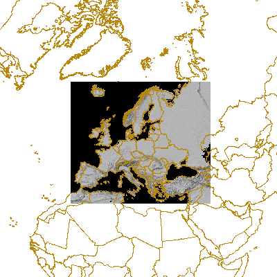
Hillshade Europe DEM
This is a cropped DTM version (with Frame2c) for providing topographic backgrouds on EEA maps.
This is a hillshade of global digital elevation model (DEM) with a horizontal grid spacing of 30 arc seconds (approximately 1 kilometer).
Simple
Identification info
- Date (Publication)
- 2004-01-15
- Date (Creation)
- 2004-01-15
- Citation identifier
- eea_r_777100_100_m_hillshade_p_1996_v01_r00
- Status
- Obsolete
- Point of contact
-
Organisation Individual Electronic mail address Website Role European Environment Agency
Point of contact European Environment Agency
Custodian
- Spatial representation type
- Grid
Spatial resolution
- Spatial resolution
- 100 m
- Topic category
-
- Environment
- Geoscientific information
Extent
))
Extent
Temporal extent
- Time period
- 1996-01-01 1996-12-30
- Maintenance and update frequency
- Unknown
Resource constraints
- Use limitation
-
License CC-BY 4.0 ( https://creativecommons.org/licenses/by/4.0/). Copyright holder: European Environment Agency (EEA).
Resource constraints
- Access constraints
- Other restrictions
- Other constraints
- no limitations to public access
- Language
- English
- Character encoding
- UTF8
Data quality info
- Hierarchy level
- Dataset
Report
Result
- Title
- Commission Regulation (EU) No 1089/2010 of 23 November 2010 implementing Directive 2007/2/EC of the European Parliament and of the Council as regards interoperability of spatial data sets and services
- Date (Publication)
- 2010-12-08
- Explanation
-
See the referenced specification
Resource lineage
- Statement
-
The data set was compiled by EEA and is derived from the GTOPO30 dataset ( http://edcdaac.usgs.gov/gtopo30/gtopo30.html). The DTM was converted to raster (georefernced tiff) using Arcview and Grid Pig extension. The Caspian Sea border, the Africa depression and some areas from the Netherlands, all under sea level were corrected.
The DTM was hillshaded using ArcMap and Spatial Analyst using following parametres: Azimuth: 315, Altitude: 45, Model shadows: Yes, Z factor: 10, Cell size: 1000 m.
- Hierarchy level
- Dataset
Reference System Information
- Reference system identifier
- European Environment Agency/urn:ogc:def:crs:EEA:1.0:777100
Metadata
- Metadata identifier
- 84036394-19fc-466f-bc4b-b0748d5d29f4
- Language
- English
- Character encoding
- UTF8
- Contact
-
Organisation Individual Electronic mail address Website Role European Environment Agency
Point of contact
Type of resource
- Resource type
- Dataset
- Metadata linkage
-
https://sdi.eea.europa.eu/geonetwork/srv/api/records/84036394-19fc-466f-bc4b-b0748d5d29f4
- Date info (Creation)
- 2010-08-06T09:24:09Z
- Date info (Revision)
- 2025-10-09T11:00:57.631605Z
Metadata standard
- Title
-
ISO 19115/19139
- Edition
-
1.0
)))