 EEA geospatial data catalogue
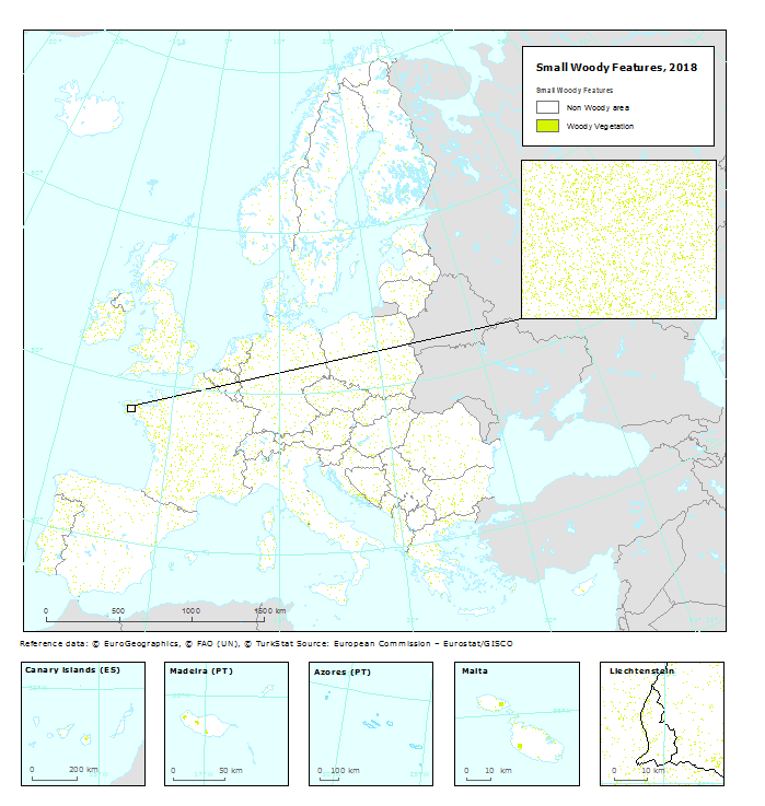
Small Woody Features 2018 (raster 100 m), Europe, 3-yearly, May 2023
High Resolution land cover characteristics for the 2018 reference year. Small woody landscape features are important vectors of biodiversity and provide information on fragmentation of habitats with a direct potential for restoration while also providing a link to hazard protection and green infrastructure, amongst others. VHR_IMAGE_2018 made available in the ESA Copernicus DWH will be the main data source for the detection of small woody features identifiable within the given image resolution. The Small Woody Features (SWFs) layer contains woody linear and patchy elements but will not be further differentiated into trees, hedges, bushes and scrub. The spatial pattern shall be limited to linear structures and isolated patches on the basis of geometric characteristics.
Simple
Identification info
-
Date (Publication)
- 2023-05-10
-
Edition
-
01.00
-
Citation identifier
- copernicus_r_3035_100_m_swf-2018_p_2017-2019_v01_r00
Identifier
-
Spatial representation type
-
Grid
Spatial resolution
-
Spatial resolution
- 100 m
-
Topic category
-
-
Environment
-
Imagery base maps earth cover
-
Extent
))
Temporal extent
-
Time period
- 2017-01-01 2019-12-31
-
Maintenance and update frequency
-
Continual
- Continents, countries, sea regions of the world.
-
-
EEA39
-
Resource constraints
-
Access constraints
-
Other restrictions
-
Other constraints
- no limitations to public access
Resource constraints
-
Use constraints
-
Other restrictions
-
Other constraints
-
The Copernicus component is governed by Regulation (EU) No 2021/696 of the European Parliament and of the Council of 28 April 2021 establishing the Union Space Programme and the European Union Agency for the Space Programme and repealing Regulations (EU) No 912/2010, (EU) No 1285/2013 and (EU) No 377/2014 and Decision No 541/2014/EU. Within the Copernicus component, a portfolio of land monitoring activities has been delegated by the European Union to the European Environment Agency (EEA) and the DG Joint Research Centre of the European Commission.
The Copernicus land monitoring products and services are made available on a principle of full, open and free access, as established by the Commission Delegated Regulation (EU) No 1159/2013 of 12 July 2013.
Free, full and open access to the products and services of the Copernicus Land Monitoring Service is made on the conditions that:
1. When distributing or communicating Copernicus Land Monitoring Service products and services (data, software scripts, web services, user and methodological documentation and similar) to the public, users shall inform the public of the source of these products and services.
2. Where the Copernicus Land Monitoring Service products and services have been adapted or modified by the user, the user shall clearly state this.
3. Users shall make sure not to convey the impression to the public that the user's activities are officially endorsed by the European Union.
-
Language
- English
-
Character encoding
-
UTF8
Distribution Information
-
Distribution format
-
-
GeoTIFF
-
-
OnLine resource
-
CLMS Website
Download (requires authentication)
-
OnLine resource
-
Product Information & Technical Documentation
Data quality info
-
Hierarchy level
-
Dataset
Report
Result
-
Date (Publication)
- 2023-05-10
-
Explanation
-
See the referenced specification
Resource lineage
-
Statement
-
The HRL Small Woody Feature Raster Product is primarily based on a supervised classification of satellite image time-series from VHR_IMAGE_2018 acquired from May 2017 to September 2019.
Geometric specifications: The Pixel resolution for the status product is 5m x 5 m. MMU, MML and MMW is applied on the vector product from which the raster product is derived. This aggregated product has a spatial resolution of 100 x 100 m.
Vector product: For patchy structures of trees and scrub the MMU is >200 m2 (size limit of 50 000m2). The MMW for linear structures/elements is < 30m. The MML for linear structures/elements is of >30 m length.
The positional accuracy is less than 5 m.
Quality assurance follows the ISO 9001:2015 standards for Quality Management and comprises of dedicated procedures of quality checks (QA breakpoints) during implementation of the production chain, in order to keep persistent control over the various stages of production, assure fitness-for-purpose of the end-products and that all quality requirements are fulfilled. Priority has been given to the target thematic accuracy to be achieved by each product, as well as to the issues of product consistency (spatial, thematic, temporal) and homogeneity.
Quality Assessment: The quality assessment has been performed according to INSPIRE Data Specifications. The data quality elements considered are: (i) Completeness, (ii) Logical Consistency, (iii) positional accuracy, (iv) Thematic Accuracy, (v) Temporal quality and (vi) Usability.
Accuracy assessment approach: stratified random point sampling. Interpretation of sampling points has been performed on the best available reference data. The general accuracy level of the HRL SWF products shall be in the order of 80 % for Overall thematic Accuracy, User’s Accuracy and Producer’s Accuracy.
-
Hierarchy level
-
Dataset
Reference System Information
Reference System Information
-
Code
- EPSG:3035
-
Maintenance and update frequency
Metadata
-
Metadata identifier
- 89eeb6c1-ee72-44b3-b0e3-83c74f2c306d
-
Language
- English
-
Character encoding
-
UTF8
- Contact
-
Organisation Individual Electronic mail address Website Role European Environment Agency
Point of contact
Type of resource
-
Resource type
-
Dataset
-
Metadata linkage
-
https://sdi.eea.europa.eu/catalogue/srv/api/records/89eeb6c1-ee72-44b3-b0e3-83c74f2c306d
-
Date info (Creation)
- 2023-05-11T13:11:25.822Z
-
Date info (Revision)
- 2025-10-09T11:02:14.373371Z
Metadata standard
-
Title
-
ISO 19115/19139
-
Edition
-
1.0
)))