 EEA geospatial data catalogue
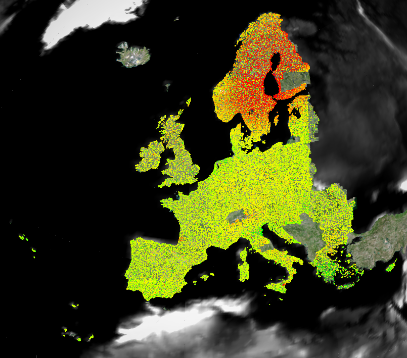
European Ground Motion Service: Ortho – Vertical Component 2018-2022 (vector), Europe, yearly, Oct. 2023
The European Ground Motion Service (EGMS) is a component of the Copernicus Land Monitoring Service. EGMS provides consistent, regular, standardised, harmonised and reliable information regarding natural and anthropogenic ground motion phenomena over the Copernicus Participating States and across national borders, with millimetre accuracy. This set of metadata describes the third product level of EGMS: Ortho.
The EGMS Ortho product exploits the information provided by ascending and descending orbits of the Calibrated product ( https://sdi.eea.europa.eu/catalogue/srv/eng/catalog.search#/metadata/d92e61be-d6e8-4bc1-aa10-f742bf27bab9) to derive two further layers; one of purely vertical displacements (the one described by this metadata), the other of purely east-west displacements. Both layers are resampled to a 100 m grid. The Ortho product eases the interpretation process of non-experts since the viewing geometry has not to be considered anymore.
EGMS Ortho is visualised as a vector map of measurement points colour-coded by average velocity (vertical or east-west components) and distributed to users in comma-separated values format. Each point is associated with a time series of displacement, i.e. a plot with values of displacement per acquisition of the satellite.
Simple
Identification info
-
Date (Creation)
- 2023-03-15
-
Date (Publication)
- 2023-10-25
-
Edition
-
01.00
-
Citation identifier
- copernicus_v_3035_100_m_egms-ortho-vert_p_2018-2022_v01_r00
Identifier
-
Status
-
Superseded
-
Spatial representation type
-
Vector
Spatial resolution
-
Spatial resolution
- 100 m
-
Topic category
-
-
Geoscientific information
-
Extent
))
Temporal extent
-
Time period
- 2018-01-01 2022-12-31
Extent
))
Extent
))
-
Maintenance and update frequency
-
Annually
- GEMET - INSPIRE themes, version 1.0
-
-
Natural risk zones
-
- Continents, countries, sea regions of the world.
-
-
United Kingdom
-
Norway
-
Iceland
-
EU27 (from 2020)
-
- GEMET
-
-
built environment
-
geo-referenced data
-
infrastructure
-
geological process
-
risk reduction
-
urban area
-
earth observation
-
landslide
-
subsidence
-
- Temporal resolution
-
-
Weekly
-
- EEA Management Plan
-
-
2023 6.5.32
-
Resource constraints
-
Access constraints
-
Other restrictions
-
Other constraints
- no limitations to public access
Resource constraints
-
Use constraints
-
Other restrictions
-
Other constraints
-
The Copernicus component is governed by Regulation (EU) No 2021/696 of the European Parliament and of the Council of 28 April 2021 establishing the Union Space Programme and the European Union Agency for the Space Programme and repealing Regulations (EU) No 912/2010, (EU) No 1285/2013 and (EU) No 377/2014 and Decision No 541/2014/EU. Within the Copernicus component, a portfolio of land monitoring activities has been delegated by the European Union to the European Environment Agency (EEA) and the DG Joint Research Centre of the European Commission.
The Copernicus land monitoring products and services are made available on a principle of full, open and free access, as established by the Commission Delegated Regulation (EU) No 1159/2013 of 12 July 2013.
Free, full and open access to the products and services of the Copernicus Land Monitoring Service is made on the conditions that:
1. When distributing or communicating Copernicus Land Monitoring Service products and services (data, software scripts, web services, user and methodological documentation and similar) to the public, users shall inform the public of the source of these products and services.
2. Where the Copernicus Land Monitoring Service products and services have been adapted or modified by the user, the user shall clearly state this.
3. Users shall make sure not to convey the impression to the public that the user's activities are officially endorsed by the European Union.
-
Language
- English
-
Character encoding
-
UTF8
Distribution Information
-
Distribution format
-
-
ascii (.csv, .txt, .sql)
-
-
OnLine resource
-
EGMS Explorer
Viewing and download
-
OnLine resource
-
Service documentation
-
OnLine resource
-
Scientific paper
A scientific paper on the EGMS production system and results: Costantini et al., 2021 IGARSS21
Data quality info
-
Hierarchy level
-
Dataset
Report
Result
-
Title
- Commission Regulation (EU) No 1089/2010 of 23 November 2010 implementing Directive 2007/2/EC of the European Parliament and of the Council as regards interoperability of spatial data sets and services
-
Date (Publication)
- 2010-12-08
-
Explanation
-
See the referenced specification
Resource lineage
-
Statement
-
The Ortho product is based on the decomposition of the Calibrated product to provide two discrete geospatial layers containing purely vertical (the one described in this metadata) and purely east-west displacements resampled to a 100 m grid. In summary, the process involves the following tasks:
i) identify all the cells with at least one measurement point per orbit,
ii) average the time series per orbit,
iii) interpolate ascending and descending time series to a common six-day sampling and
iv) estimate the vertical and east-west components following equations weighted on the estimated accuracy of the input measurements.
-
Hierarchy level
-
Dataset
Reference System Information
Reference System Information
-
Code
- EPSG:3035
Reference System Information
Reference System Information
-
Code
- EPSG:32740
Reference System Information
Reference System Information
-
Code
- EPSG:32620
Reference System Information
Reference System Information
-
Code
- EPSG:32622
Reference System Information
Reference System Information
-
Code
- EPSG:32738
-
Maintenance and update frequency
Metadata
-
Metadata identifier
- 943e9cbb-f8ef-4378-966c-63eb761016a9
-
Language
- English
-
Character encoding
-
UTF8
- Contact
-
Organisation Individual Electronic mail address Website Role European Environment Agency
Point of contact
Type of resource
-
Resource type
-
Dataset
-
Metadata linkage
-
https://sdi.eea.europa.eu/catalogue/srv/api/records/943e9cbb-f8ef-4378-966c-63eb761016a9
-
Date info (Creation)
- 2023-10-24T15:01:40.439Z
-
Date info (Revision)
- 2025-10-09T11:04:07.002203Z
Metadata standard
-
Title
-
ISO 19115/19139
-
Edition
-
1.0
),POLYGON((-51.28%201.08,-51.28%2016.9,-62%2016.9,-62%201.08,-51.28%201.08)),POLYGON((56.25%20-21.6,56.25%20-12.45,44.75%20-12.45,44.75%20-21.6,56.25%20-21.6))))