 EEA geospatial data catalogue
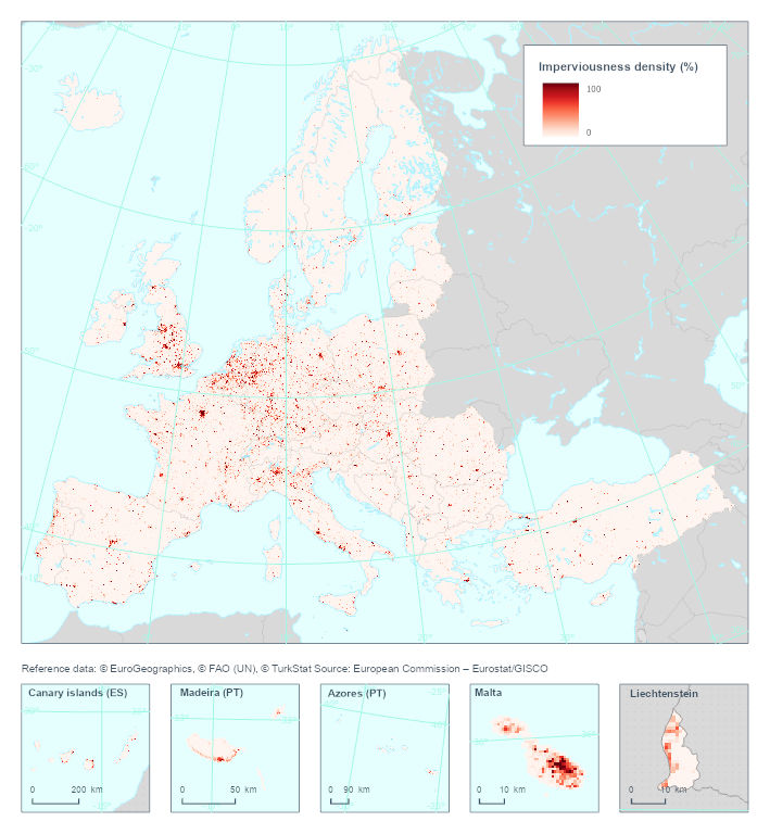
Harmonized imperviousness layer 2012 (raster 1km), Feb. 2024
This metadata describes the Harmonized Imperviousness raster dataset for the year 2012. This raster dataset is part of the harmonized and bias-corrected soil sealing time series for Europe produced by the EEA for the observation period (2006-2018) based on the Copernicus Imperviousness Degree (IMD) layers.
The 2018 Imperviousness Degree (IMD) layer of the Copernicus Land Monitoring Service (CLMS) was produced on a 10m spatial resolution taking advantage of the availability of Sentinel 2 data, whereas earlier layers are provided on 20m resolution. The 20m resolution IMD time-series (2006-2009-2012-2015) was harmonized by the CLMS and have shown a credible evolution in sealed cover. The upgrade from 20m to 10m spatial resolution however resulted in a break in the IMD based areal statistics.
The harmonized imperviousness time series layers combine visual interpretation and modelling with the original CLMS Imperviousness Density layers and the CLMS CLC+ Backbone raster layer to overcome the above mentioned resolution change and to provide a harmonized time series for the monitoring of the evolution of soil sealing.
The production of the dataset was supported by the Directorate-General for Regional and Urban Policy of the European Commission under Service Level Agreement 2021CE160AT130.
Simple
Identification info
- Date (Creation)
- 2024-02-01
- Date (Publication)
- 2024-06-27
- Edition
-
01.00
- Citation identifier
- eea_r_3035_1_km_imperviousness-layer_p_2012_v01_r00
Identifier
- Point of contact
-
Organisation Individual Electronic mail address Website Role European Environment Agency
Point of contact European Environment Agency
Custodian
- Spatial representation type
- Grid
Spatial resolution
Equivalent scale
- Denominator
- 100000
Spatial resolution
- Spatial resolution
- 1000 m
- Topic category
-
- Environment
Extent
))
Temporal extent
- Time period
- 2012-01-01 2014-12-31
Extent
- Maintenance and update frequency
- threeYears
- Continents, countries, sea regions of the world.
-
-
United Kingdom
-
EEA38 (from 2020)
-
- EEA Management Plan
-
-
2024 2.2.4
-
Resource constraints
- Access constraints
- Other restrictions
- Other constraints
- no limitations to public access
Resource constraints
- Use constraints
- Other restrictions
- Other constraints
-
License CC-BY 4.0 ( https://creativecommons.org/licenses/by/4.0/). Copyright holder: European Environment Agency (EEA).
- Language
- English
Distribution Information
- Distribution format
-
-
GeoTIFF
-
- OnLine resource
-
Direct download
- OnLine resource
-
ETC-DI 2024 report
- OnLine resource
-
Harmonized Pan-European Time Series for Monitoring Soil Sealing
https://doi.org/10.3390/land13071087
Data quality info
- Hierarchy level
- Dataset
Report
Result
- Title
- Commission Regulation (EU) No 1089/2010 of 23 November 2010 implementing Directive 2007/2/EC of the European Parliament and of the Council as regards interoperability of spatial data sets and services
- Date (Publication)
- 2010-12-08
- Explanation
-
See the referenced specification
Report
- Name of measure
-
Minimum Mapping Width
Result
- Identifier
- m
Resource lineage
- Statement
-
the CLMS has been producing a new dataset from 2018 onward entitled the CORINE Land Cover (CLC)+ Back Bone raster which also include a sealed area thematic class. When comparing the IMD and CLC+ Backbone Raster datasets with sampled reference data, it appears that the imperviousness dataset substantially underestimates sealed areas at European level see Sannier et al., 2024 ( https://doi.org/10.3390/land13071087 ) and ETC/DI, 2024.
The CLC+ dataset only started to be available from 2018 and currently does not include any change layer. To address these issues, a combined, harmonized and bias-corrected soil sealing dataset for Europe was produced by the EEA for the entire observation period.
For the geometric harmonization of the CLMS IMD time series for 2006, 2009, 2012, 2015 and 2018 the following steps were used:
1. Create Sealed 2018 status by extracting class 1 from CLC+ Backbone 2018 (10m) (set all other classes to 0).
2. Create the Sealed 2015 accounting status layer by combining Sealed 2018 status with IMCC1518accounting:
a. Resample 20m resolution IMCC1518accounting to 10m resolution.
b. Combine IMCC1518accounting sealing increase with Sealed 2018 status: IF Sealed 2018 status is sealed (value=1) and IMCC1518accounting is class “new cover” THEN write new Sealed 2015 accounting status layer with value “unsealed” (unsealed=0) at corresponding grid cell.
c. Combine IMCC1518accounting sealing decrease with Sealed 2018 status: IF Sealed 2018 status is not sealed (value=0) and change is “loss of cover” THEN write new Sealed 2015 accounting status layer with value “sealed” (sealed=1) at corresponding grid cell.
d. For the rest of the pixel copy the values (sealed/unsealed, i.e. 1/0) from the Sealed 2018 status layer
3. Create the Sealed 2012 accounting status layer by combining Sealed 2015 status with IMCC1215
a. Resample 20m resolution IMCC1215 to 10m resolution
b. Combine CLMS IMCC1215 sealing increase with Sealed 2015 accounting status: IF Sealed 2015 accounting status is sealed (value=1) and CLMS IMCC1215 is class “new cover” THEN write new Sealed 2012 accounting status layer with value “unsealed” (unsealed = 0) at corresponding grid cell.
c. Combine CLMS IMCC1215 sealing decrease with Sealed 2015 status: IF Sealed 2015 status is not sealed (value =0) and change is “loss of cover” THEN write new Sealed 2012 status layer with value “sealed” (sealed=1) at corresponding grid cell.
d. For the rest of the pixel copy the values (sealed/unsealed, i.e. 1/0) from the Sealed 2015 status layer
4. Create the Sealed 2009 accounting status layer by combining Sealed 2012 status with IMCC0912
a. Resample 20m resolution IMCC0912 to 10m resolution
b. Combine CLMS IMCC0912 sealing increase with Sealed 2012 accounting status: IF Sealed 2012 accounting status is sealed (value=1) and CLMS IMCC0912 is class “new cover” THEN write new Sealed 2009 accounting status layer with value “unsealed” (unsealed = 0) at corresponding grid cell.
c. Combine CLMS IMCC0912 sealing decrease with Sealed 2012 status: IF Sealed 2012 status is not sealed (value =0) and change is “loss of cover” THEN write new Sealed 2009 status layer with value “sealed” (sealed=1) at corresponding grid cell.
d. For the rest of the pixel copy the values (sealed/unsealed, i.e. 1/0) from the Sealed 2012 status layer
5. Create the Sealed 2006 accounting status layer by combining Sealed 2009 status with IMCC0609
a. Resample 20m resolution IMCC0609 to 10m resolution
b. Combine CLMS IMCC0609 sealing increase with Sealed 2009 accounting status: IF Sealed 2009 accounting status is sealed (value=1) and CLMS IMCC0609 is class “new cover” THEN write new Sealed 2006 accounting status layer with value “unsealed” (unsealed = 0) at corresponding grid cell.
c. Combine CLMS IMCC0609 sealing decrease with Sealed 2009 status: IF Sealed 2009 status is not sealed (value =0) and change is “loss of cover” THEN write new Sealed 2006 status layer with value “sealed” (sealed=1) at corresponding grid cell.
d. For the rest of the pixel copy the values (sealed/unsealed, i.e. 1/0) from the Sealed 2009 status layer
For further processing the time series was converted to 1km grid size which was the best compromise in terms of reporting on sealed soil surface and available resources. In the next step a visually interpreted reference database was created, where within 1kmx1km primary sampling units (PSUs) 100 secondary sampling units (SSUs) were selected on a regular grid. With a non-linear regression estimate a relationship was established between the visually interpreted ground truth and the 1km harmonized layers. The regression estimate was applied to the harmonized layers and a new 1km harmonized and corrected time series was created.
- Hierarchy level
- Dataset
Reference System Information
Reference System Information
- Code
- EPSG:3035
Metadata
- Metadata identifier
- 971345a4-c826-49ab-9c61-46d48dbc509b
- Language
- English
- Character encoding
- UTF8
- Contact
-
Organisation Individual Electronic mail address Website Role European Environment Agency
Point of contact
Type of resource
- Resource type
- Dataset
- Date info (Creation)
- 2024-06-27T12:13:44.291563Z
- Date info (Revision)
- 2025-10-09T11:04:53.593907Z
Metadata standard
- Title
-
ISO 19115/19139
- Edition
-
1.0
)))