 EEA geospatial data catalogue
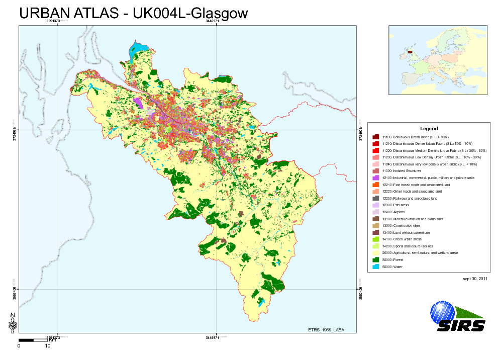
Urban Atlas - United Kingdom - Glasgow
The Urban Atlas is providing pan-European comparable land use and land cover data for Large Urban Zones with more than 100.000 inhabitants as defined by the Urban Audit. Urban Atlas' mission is to provide high-resolution hotspot mapping of changes in urban spaces and indicators for users such as city governments, the European Environment Agency (EEA) and European Commission departments.
Simple
Identification info
- Date (Publication)
- 2010-05-28
- Date (Creation)
- 2010-05-28
- Citation identifier
- regio_v_32630_10_k_ua-uk004l_p_2009-2010_v01_r00
- Status
- Obsolete
- Point of contact
-
Organisation Individual Electronic mail address Website Role European Environment Agency
Point of contact
- Spatial representation type
- Vector
Spatial resolution
Equivalent scale
- Denominator
- 10000
- Topic category
-
- Society
Extent
))
Extent
Temporal extent
- Time period
- 2009-05-30 2010-09-26
- EEA topics
-
-
Land use
-
Sustainability solutions
-
- GEMET - INSPIRE themes, version 1.0
-
-
Land use
-
- GEMET
-
-
urban area
-
land use
-
- Place
-
-
United Kingdom
-
Glasgow
-
Resource constraints
- Use limitation
-
License CC-BY 4.0 ( https://creativecommons.org/licenses/by/4.0/). Copyright holder: Directorate-General Enterprise and Industry.
Resource constraints
- Access constraints
- Other restrictions
- Other constraints
- no limitations to public access
- Language
- English
- Character encoding
- UTF8
Data quality info
- Hierarchy level
- Dataset
Report
Result
- Title
-
Commission Regulation (EU) No 1089/2010 of 23 November 2010 implementing Directive 2007/2/EC of the European Parliament and of the Council as regards interoperability of spatial data sets and services
- Date (Publication)
- 2010-12-08
- Explanation
-
See the referenced specification
Resource lineage
- Statement
-
Earth Observation (EO) Data used:
* Spot 5 2,50 m - 50182361009261159112B0 (PS) (Date: 2010/09/26)
* Spot 5 2,50 m - 50212360911081148352B0 (PS) (Date: 2009/11/08)
* Spot 5 2,50 m - 50212370911081148442B0 (PS) (Date: 2009/11/08)
* RapidEye 5 m - 2009-05-30T121236_RE1_3A-NAC_5649383_105639 (XS) (Date: 2009/05/30)
* RapidEye 5 m - 2009-05-30T121237_RE1_3A -NAC_5649421_105639 (XS) (Date: 2009/05/30)
* RapidEye 5 m - 2009-05-30T121240_RE1_3A -NAC_5649262_105639 (XS) (Date: 2009/05/30)
* RapidEye 5 m - 2009-05-30T121241_RE1_3A -NAC_5649260_105639 (XS) (Date: 2009/05/30)
* RapidEye 5 m - 2009-05-30T121242_RE1_3A -NAC_5649520_105639 (XS) (Date: 2009/05/30)
* RapidEye 5 m - 2009-05-30T121244_RE1_3A -NAC_5649263_105639 (XS) (Date: 2009/05/30)
* RapidEye 5 m - 2009-06-29T122216_RE2_3A -NAC_5650404_105639 (XS) (Date: 2009/06/29)
* RapidEye 5 m - 2009-08-22T121338_RE4_3A -NAC_5650333_105639 (XS) (Date: 2009/08/22)
* RapidEye 5 m - 2009-08-22T121342_RE4_3A -NAC_5650331_105639 (XS) (Date: 2009/08/22)
* RapidEye 5 m - 2009-08-22T121345_RE4_3A -NAC_5650330_105639 (XS) (Date: 2009/08/22)
* RapidEye 5 m - 2009-08-22T121345_RE4_3A -NAC_5650332_105639 (XS) (Date: 2009/08/22)
* RapidEye 5 m - 2009-09-12T121637_RE1_3A -NAC_5649384_105639 (XS) (Date: 2009/09/12)
* RapidEye 5 m - 2009-09-12T121638_RE1_3A -NAC_5649522_105639 (XS) (Date: 2009/09/12)
* RapidEye 5 m - 2009-10-16T121016_RE2_3A -NAC_5649420_105639 (XS) (Date: 2009/10/16)
* RapidEye 5 m - 2009-10-16T121016_RE2_3A -NAC_5649349_105639 (XS) (Date: 2009/10/16)
* RapidEye 5 m - 2009-10-16T121019_RE2_3A -NAC_5649519_105639 (XS) (Date: 2009/10/16)
* RapidEye 5 m - 2009-10-16T121020_RE2_3A -NAC_5649261_105639 (XS) (Date: 2009/10/16)
* RapidEye 5 m - 2009-10-16T121023_RE2_3A -NAC_5649346_105639 (XS) (Date: 2009/10/16)
* RapidEye 5 m - 2009-10-16T121026_RE2_3A -NAC_5649518_105639 (XS) (Date: 2009/10/16)
* RapidEye 5 m - 2009-10-16T121027_RE2_3A -NAC_5649347_105639 (XS) (Date: 2009/10/16)
- Hierarchy level
- Dataset
Reference System Information
- Reference system identifier
- OGP Surveying & Positioning Committee/urn:ogc:def:crs:EPSG:7.1:32630
Metadata
- Metadata identifier
- 97435b77-4cbb-4aa8-a611-d8905b66483a
- Language
- English
- Character encoding
- UTF8
- Contact
-
Organisation Individual Electronic mail address Website Role European Environment Agency
Point of contact
Type of resource
- Resource type
- Dataset
- Metadata linkage
-
https://sdi.eea.europa.eu/geonetwork/srv/api/records/97435b77-4cbb-4aa8-a611-d8905b66483a
- Date info (Creation)
- 2012-01-31T13:32:30Z
- Date info (Revision)
- 2025-10-09T11:04:56.95752Z
Metadata standard
- Title
-
ISO 19115/19139
- Edition
-
1.0
)))