 EEA geospatial data catalogue
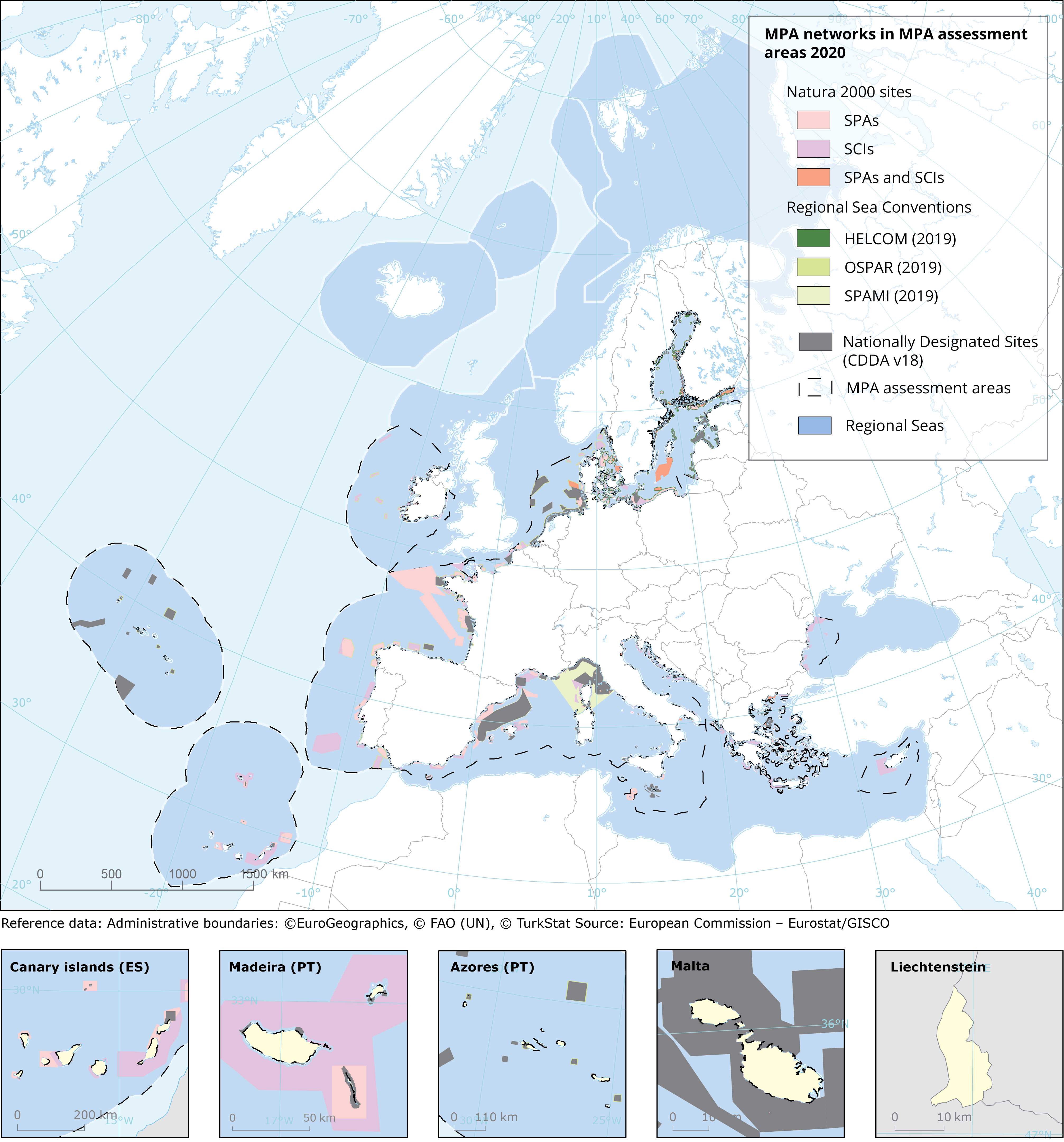
Marine Protected Area (MPA) networks in MPA assessment areas, Ver. 2019
The map shows distribution and delineation of Marine Protected Areas (MPA) networks in MPA assessment areas of the European regional seas. Here, MPA networks consist of all the different considered networks: Natura 2000, Nationally Designates Sites (NDS), and Regional Sea Convention (RSC) sites. The baseline information is based on MPA data reported at the end of 2019. The spatial extent of the MPA assessment areas was defined as the marine waters surrounding the EU countries whose outer limit is defined by the 200 NM boundary from the coast (possibly coinciding with formally recognised EEZ boundaries) or the equidistance (in cases of opposite neighbouring EU countries), or by the presence of a boundary defined by an agreed treaty.Geographical Information System (GIS) and tabular data sets used, and further details on this map can be found in the ETC/ICM report Spatial Analysis of Marine Protected Area Networks in Europe’s Seas III: https://www.eionet.europa.eu/etcs/etc-icm/products/etc-icm-report-3-2020-spatial-analysis-of-marine-protected-area-networks-in-europe2019s-seas-iii.
Simple
Identification info
- Date (Creation)
- 2020-12-09
- Date (Publication)
- 2020-12-09
- Edition
-
01.00
- Citation identifier
- eea_v_3035_100_k_mpa-network-mpa-assessment-area_p_2019_v01_r00
- Purpose
-
Distribution of Marine Protected Area (MPA) networks in MPA assessment areas of the European regional seas.
- Status
- Superseded
- Point of contact
-
Organisation Individual Electronic mail address Website Role European Environment Agency
Point of contact European Environment Agency
Custodian
- Spatial representation type
- Vector
Spatial resolution
Equivalent scale
- Denominator
- 100000
- Topic category
-
- Environment
- Oceans
Extent
))
Extent
Temporal extent
- Time period
- 2019-01-01 2019-12-31
- Maintenance and update frequency
- As needed
- Continents, countries, sea regions of the world.
-
-
Aegean Sea
-
Northeast Atlantic Ocean (40W)
-
Mediterranean Sea, Western Basin
-
Celtic Sea
-
Ionian Sea
-
Baltic Sea
-
Adriatic Sea
-
Bay of Biscay
-
Mediterranean Sea
-
Black Sea
-
Resource constraints
- Access constraints
- Other restrictions
- Other constraints
- no limitations to public access
Resource constraints
- Use constraints
- Other restrictions
- Other constraints
-
License CC-BY 4.0 ( https://creativecommons.org/licenses/by/4.0/). Copyright holder: European Environment Agency (EEA).
- Language
- English
- Character encoding
- UTF8
Distribution Information
- Distribution format
-
-
SHP
-
GDB
-
- OnLine resource
-
GDB format
- OnLine resource
-
SHP format
- OnLine resource
-
Direct download
Data quality info
- Hierarchy level
- Dataset
Report
Result
- Title
- Commission Regulation (EU) No 1089/2010 of 23 November 2010 implementing Directive 2007/2/EC of the European Parliament and of the Council as regards interoperability of spatial data sets and services
- Date (Publication)
- 2010-12-08
- Explanation
-
See the referenced specification
Resource lineage
- Statement
-
The spatial extent of the MPA assessment areas includes the marine waters surrounding the EU-27 countries whose outer limit is defined by the 200 NM (nautical miles) boundary from the coast (possibly coinciding with formally recognized Economic Exclusive Zone – EEZ- or Ecologic Protection Zone – EPZ – boundaries), or the equidistance (in cases of opposite neighbouring EU countries), or by the presence of a boundary defined by an agreed treaty.
The baseline information is based on MPA data reported at the end of 2019. The MPA datasets resources can be found in the report: https://www.eionet.europa.eu/etcs/etc-icm/products/etc-icm-report-3-2020-spatial-analysis-of-marine-protected-area-networks-in-europe2019s-seas-iii
- Hierarchy level
- Dataset
Reference System Information
Reference System Information
- Code
- EPSG:3035
- Maintenance and update frequency
- As needed
Metadata
- Metadata identifier
- a6be25b0-62d8-4ada-a809-cb0d9fd835c7
- Language
- English
- Character encoding
- UTF8
- Contact
-
Organisation Individual Electronic mail address Website Role European Environment Agency
Point of contact
Type of resource
- Resource type
- Dataset
- Name
-
dataset
- Metadata linkage
-
https://sdi.eea.europa.eu/catalogue/srv/api/records/a6be25b0-62d8-4ada-a809-cb0d9fd835c7
- Date info (Creation)
- 2022-01-31T12:57:36.986Z
- Date info (Revision)
- 2025-10-09T11:07:29.659469Z
Metadata standard
- Title
-
INSPIRE Metadata Implementing Rules: Technical Guidelines based on EN ISO 19115 and EN ISO 19119
- Edition
-
V. 2.0.1
)))