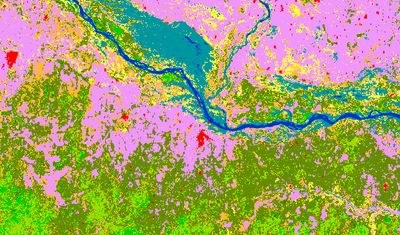
Land Cover 2015-2019 (raster 100 m), global, annual - version 3
The Global Dynamic Land Cover product offers annual global land cover maps and cover fraction layers, providing a detailed view of land cover at three classification levels. It uses modern data analysis techniques to ensure temporal consistency and accuracy, with the latest version achieving 80% accuracy at class level 1 on each continent. The product also includes continuous field layers, or "fraction maps", that provide proportional estimates for vegetation and ground cover for the land cover types. These features make it a versatile tool for a wide range of applications, including forest monitoring, rangeland management, crop monitoring, biodiversity conservation, climate modelling, and urban planning.
Dynamic land cover maps include transitions of land cover classes over time and hence captures land cover changes.
This Collection 3 includes the global land cover maps, at 100m resolution, for base year 2015 and subsequent years until 2019. These consist of different layers: the base classification with 23 classes, versatile fractional cover (0-100% per pixel) for the main classes, forest type and related quality information (e.g. classification probability, input data density and confidence level for the change detection).
Simple
Identification info
-
Date (Creation)
- 2015-01-01
-
Date (Publication)
- 2015-01-01
-
Edition
-
3.0
-
Edition date
- 2019-05-14T00:00:00
-
Citation identifier
- clms_r_4326_100_m_lcc-yearly-global_p_2015-2020_v3_r00
-
Citation identifier
- clms_global_lcc_100m_v3_yearly
-
Title
-
VITO NV
-
Date (Revision)
- 2020-01-01
-
Identifier
-
Other citation details
-
https://land.copernicus.eu/en/products/global-dynamic-land-cover
-
Purpose
-
This product is first designed to fit the requirements of the Global component of the Copernicus Land Service. It can be also useful for all applications related to the environment monitoring.
-
Credit
-
Land Cover products were generated by the Global component of the Land Service of Copernicus, the Earth Observation programme of the European Commission. The research leading to the current version of the product has received funding from various European Commission Research and Technical Development programs. The product is based on PROBA-V 100m and 333m data (copyright BELSPO and distribution by VITO NV), as well as renowned external datasets (e.g. World Settlement Footprint by DLR, Global Surface Water by the EC Joint Research Centre, OpenStreetMap).
- Point of contact
-
Organisation Individual Electronic mail address Website Role European Commission
OwnerCopernicus Land Monitoring Service
CustodianEuropean Commission's Joint Research Centre
PublisherCopernicus Land Monitoring Service helpdesk
Point of contact
-
Spatial representation type
-
Grid
Spatial resolution
-
Spatial resolution
- 0.000992063492063 http://standards.iso.org/ittf/PubliclyAvailableStandards/ISO_19139_Schemas/resources/uom/ML_gmxUom.xml#deg
-
Topic category
-
-
Imagery base maps earth cover
-
Biota
-
Environment
-
Farming
-
Extent
))
Extent
Temporal extent
-
Time period
- year composite base_year 2015-01-01T00:00:00Z 2019-12-31T23:59:59Z
-
Maintenance and update frequency
-
As needed
-
mmi:updateScope
-
Series
Resource format
-
Title
-
GeoTIFF
-
Alternate title
-
Extension of Tagged Image File Format (TIFF) Revision 6.0 for georeferenced or geocoded raster imagery
-
Date
-
Edition
-
1.0
- Continents, countries, sea regions of the world.
-
-
World
-
-
Theme
-
-
land cover
-
LC
-
-
Place
-
-
Globe
-
-
Temporal
-
-
Year
-
- Copernicus Themes
-
-
Vegetation
-
- Copernicus Variables
-
-
Dynamic Land Cover
-
Resource constraints
-
Access constraints
-
Other restrictions
-
Other constraints
- no limitations to public access
Resource constraints
-
Use constraints
-
Other restrictions
-
Other constraints
-
The Copernicus component is governed by Regulation (EU) No 2021/696 of the European Parliament and of the Council of 28 April 2021 establishing the Union Space Programme and the European Union Agency for the Space Programme and repealing Regulations (EU) No 912/2010, (EU) No 1285/2013 and (EU) No 377/2014 and Decision No 541/2014/EU. Within the Copernicus component, a portfolio of land monitoring activities has been delegated by the European Union to the European Environment Agency (EEA) and the DG Joint Research Centre of the European Commission.
The Copernicus land monitoring products and services are made available on a principle of full, open and free access, as established by the Commission Delegated Regulation (EU) No 1159/2013 of 12 July 2013.
Free, full and open access to the products and services of the Copernicus Land Monitoring Service is made on the conditions that:
1. When distributing or communicating Copernicus Land Monitoring Service products and services (data, software scripts, web services, user and methodological documentation and similar) to the public, users shall inform the public of the source of these products and services.
2. Where the Copernicus Land Monitoring Service products and services have been adapted or modified by the user, the user shall clearly state this.
3. Users shall make sure not to convey the impression to the public that the user's activities are officially endorsed by the European Union.
-
Language
- English
-
Character encoding
-
UTF8
Distribution Information
-
Distribution format
-
-
GeoTIFF
-
-
Fees
-
Free
-
Ordering instructions
-
Products can be viewed, downloaded and analyzed online, with free and open access.
-
Units of distribution
-
Per product
-
OnLine resource
-
OGC WMTS
-
OnLine resource
-
Copernicus Data Space Ecosystem download services
-
Units of distribution
-
Per product
-
OnLine resource
-
Copernicus Browser
Data quality info
-
Hierarchy level
-
Dataset
Report
Result
-
Title
-
Validation results
-
Date (Publication)
- 2021-04-27
-
Explanation
-
Overall accuracy just over 80% (80.6% in 2015, 80.3% in 2019) using a set of 21K independent validation points. More details can be found in the validation report at https://land.copernicus.eu/en/products/global-dynamic-land-cover
-
Pass
- true
Report
Result
-
Date (Publication)
- 2010-12-08
-
Explanation
-
This data set is conformant with the INSPIRE Implementing Rules for the interoperability of spatial data sets and services
-
Pass
- true
Report
Result
-
Title
- INSPIRE Data Specification on orthoimagery - Guidelines
-
Date (Publication)
- 2010-04-26
-
Explanation
-
See the referenced specification
-
Pass
- true
Resource lineage
-
Statement
-
The land cover map is classified from daily surface reflectances of PROBA-V sensor and training data gathered through the GEO-WIKI. Several other products are integrated into the discrete map (LCCS layer) such as World Settlement Footprint (DLR), the Global Surface Water (JRC), OpenStreetMap, the Integrated Multi-satellitE Retrievals for GPM (NASA) and Circum-Polar Arctic Vegetation Map (U.S. CPAVM team).
The land cover is provided at 100 m resolution, however the training data is gathered at 10m resolution which has enabled to generate the continuous cover fields and provide per pixel a cover percentage (0-100%) for a set of classes.
-
Hierarchy level
-
Dataset
Spatial representation info
-
Number of dimensions
- 2
-
Dimension name
-
Row
-
Dimension size
- 141120
-
Resolution
- 0.000992063492063
-
Dimension name
-
Column
-
Dimension size
- 362880
-
Resolution
- 0.000992063492063
-
Cell geometry
-
Area
-
Transformation parameter availability
- false
-
Check point availability
- true
-
Check point description
-
Upperleft corner tiepoint
-
Description
- Upperleft corner tiepoint
-
Identifier
- upperLeftTiePoint
-
Name
- Tie Point in upper left corner
-
Pixel orientation code
-
Reference System Information
Reference System Information
-
Code
- EPSG:4326
-
Maintenance and update frequency
-
As needed
Metadata
-
Metadata identifier
- c6377c6e-76cc-4d03-8330-628a03693042
-
Language
- English
-
Character encoding
-
UTF8
- Contact
-
Organisation Individual Electronic mail address Website Role Copernicus Land Monitoring Service
Point of contact
Type of resource
-
Resource type
-
Dataset
-
Metadata linkage
-
https://sdi.eea.europa.eu/catalogue/srv/api/records/c6377c6e-76cc-4d03-8330-628a03693042
-
Date info (Creation)
- 2024-12-17T06:50:36.638592Z
-
Date info (Revision)
- 2025-10-09T11:13:55.331468Z
Metadata standard
-
Title
-
ISO 19115/19139
-
Edition
-
1.0
Overviews
Spatial extent
)))
Provided by
