 EEA geospatial data catalogue
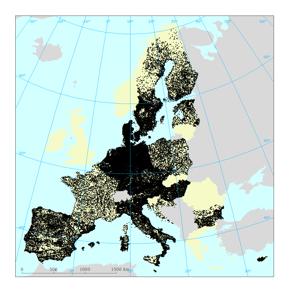
WISE WFD monitoring sites reported under Water Framework Directive 2016 - PUBLIC VERSION - version 1.1, Jul. 2017
The dataset contains information on the European monitoring sites used for the assessment of the status of surface water bodies and groundwater bodies in the 2nd River Basin Management Plans (RBMP).
The information was reported to the European Commission under the Water Framework Directive (WFD) reporting obligations.
The dataset compiles the available spatial data related to the 2nd RBMPs due in 2016 (hereafter WFD2016). See http://rod.eionet.europa.eu/obligations/715 for further information on the WFD2016 reporting.
Relevant concepts:
Monitoring site: [Operational definition. Not in the WFD] Monitoring point included in a WFD surveillance, operational or investigative monitoring programme.
Surface water body: Body of surface water means a discrete and significant element of surface water such as a lake, a reservoir, a stream, river or canal, part of a stream, river or canal, a transitional water or a stretch of coastal water.
Surface water: Inland waters, except groundwater; transitional waters and coastal waters, except in respect of chemical status for which it shall also include territorial waters.
Groundwater body: 'Body of groundwater' means a distinct volume of groundwater within an aquifer or aquifers.
Groundwater: All water which is below the surface of the ground in the saturation zone and in direct contact with the ground or subsoil.
Simple
Identification info
- Date (Creation)
- 2017-07-14
- Date (Revision)
- 2017-07-14
- Date (Publication)
- 2017-07-14
- Edition
-
1.1
- Citation identifier
- eea_v_4326_250_k_wise-msites-wfd2016_p_2016-2017_v01_r01
- Status
- Superseded
- Point of contact
-
Organisation Individual Electronic mail address Website Role European Environment Agency
Point of contact
- Spatial representation type
- Vector
Spatial resolution
Equivalent scale
- Denominator
- 250000
- Topic category
-
- Environment
- Inland waters
- Geoscientific information
Extent
))
))
))
Extent
Temporal extent
- Time period
- 2016-05-05 2017-06-29
- Maintenance and update frequency
- As needed
- GEMET - INSPIRE themes, version 1.0
-
-
Environmental monitoring facilities
-
- WISE metadata keywords, version 1.0, 2009-10-01
-
-
Water Information System for Europe (WISE)
-
Water Framework Directive (WFD)
-
Surface water
-
Surface water body
-
Monitoring station
-
Groundwater body
-
- GEMET
-
-
groundwater
-
water resources management
-
surface water
-
monitoring station
-
- Continents, countries, sea regions of the world.
-
-
Malta
-
Austria
-
Romania
-
Portugal
-
Cyprus
-
Slovakia
-
Denmark
-
Belgium
-
Croatia
-
Bulgaria
-
Spain
-
Latvia
-
Czechia
-
Italy
-
Hungary
-
Luxembourg
-
Poland
-
Finland
-
Netherlands
-
Germany
-
France
-
Estonia
-
Sweden
-
- INSPIRE - Feature Concept Dictionary, version 3
-
-
WFD Ground Water Body
-
WFD Surface Water Body
-
Surface Water
-
- EEA topics
-
-
Water
-
Resource constraints
- Use limitation
-
For further information and specification regarding the use limitations and constraints please consult the file WISE_WFD_ReferenceSpatialDataSets_2017-07-14.pdf which is provided together with the data.
Resource constraints
- Access constraints
- Other restrictions
- Other constraints
-
For further information and specification regarding the use limitations and constraints please consult the file WISE_WFD_ReferenceSpatialDataSets_2017-07-14.pdf which is provided together with the data.
- Language
- English
- Character encoding
- UTF8
Data quality info
- Hierarchy level
- Dataset
Report
Result
- Title
-
Commission Regulation (EU) No 1089/2010 of 23 November 2010 implementing Directive 2007/2/EC of the European Parliament and of the Council as regards interoperability of spatial data sets and services
- Date (Publication)
- 2010-12-08
- Explanation
-
See the referenced specification
Resource lineage
- Statement
-
1) Data model
The data set follows the WISE spatial data model described in the WISE GIS guidance, available at http://cdr.eionet.europa.eu/help/WFD/WFD_521_2016/GISGuidance/WISE_GISGuidance.pdf
The formal specification is available at http://cdr.eionet.europa.eu/help/WFD/WFD_521_2016/UML/GML_Schemas_6.0.6.zip
The shapefile templates are available at http://cdr.eionet.europa.eu/help/WFD/WFD_521_2016/Shapes/Shapefiles_6.0.6.zip
Refer to the WISE GIS guidance for the mapping between the GML elements in the XML schema and the corresponding fields in Shapefile format.
Refer to the Technical Report which accompanies the data set for information on the additional fields present in the shapefiles: cYear, country, lat, lon, statusCode, statusDate, remarks and qcCheck.
2) Data sources
For the 2nd River Basin Management Plans, spatial data was reported under the "Water Framework Directive - River Basin Management Plans - 2016 Spatial data" (hereafter WFD2016). See http://rod.eionet.europa.eu/obligations/717 for further information on the reporting.
Refer to the Technical Report which accompanies the data set the full list of CDR data sets.
3) Data processing
Refer to the Technical Report which accompanies the data set for further information.
4) Data quality
No geometric or topological error correction was performed.
Basic automated editing of string values (upper-casing, trimming, removal of invalid characters or values) was performed.
Refer to the Data Quality report of the CDR deliveries ( http://rod.eionet.europa.eu/obligations/717/deliveries) for further information.
5) WISE registers
For river basin districts and sub-units, the register of WISE thematic identifiers is kept in http://dd.eionet.europa.eu/vocabulary/wise/SpatialUnit
For surface water bodies and groundwater bodies, the register of WISE thematic identifiers is kept in http://dd.eionet.europa.eu/vocabulary/wise/WaterBody
For monitoring sites, the register of WISE thematic identifiers is kept in http://dd.eionet.europa.eu/vocabulary/wise/MonitoringSite
- Hierarchy level
- Dataset
Reference System Information
Reference System Information
- Code
- EPSG:4326
Metadata
- Metadata identifier
- c8d83fff-d35e-4bed-9afd-92e40ebe09d4
- Language
- English
- Character encoding
- UTF8
- Contact
-
Organisation Individual Electronic mail address Website Role European Environment Agency
Point of contact
Type of resource
- Resource type
- Dataset
- Metadata linkage
-
https://sdi.eea.europa.eu/catalogue/srv/api/records/c8d83fff-d35e-4bed-9afd-92e40ebe09d4
- Date info (Creation)
- 2017-09-27T15:13:47Z
- Date info (Revision)
- 2025-10-09T11:14:33.89731Z
Metadata standard
- Title
-
ISO 19115/19139
- Edition
-
1.0
),POLYGON((-50.8887%201.5818,-50.8887%2020.3034,-66.0059%2020.3034,-66.0059%201.5818,-50.8887%201.5818)),POLYGON((58.3154%20-22.4313,58.3154%20-10.8333,42.1436%20-10.8333,42.1436%20-22.4313,58.3154%20-22.4313))))