 EEA geospatial data catalogue
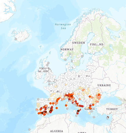
Number of combined summer days (Tmax over 30°C) and tropical nights (Tmax over 20°C) per year (1987-2016 average), Jan. 2019
The dataset presents the average number of combined hot days - with maximum temperature over 30 degrees Celsius - and tropical nights - with minimum temperature over 20 degrees Celsius - in the period 1987-2016, for a series of individual European cities from Eurostat's Urban Audit 2011-2014 spatial dataset. The associated values are based on the E-OBS dataset from the EU-FP6 project ENSEMBLES ( http://ensembles-eu.metoffice.com) and around 10,000 meteorological stations across Europe.
The combination of hot days and warm nights is particularly dangerous to human health, as the high temperatures during night time does not allow for the cities and buildings to cool down. Such combination, if lasting over several days (heatwaves) can have severe health implications or even be fatal to the elderly, babies or those in poor health. Therefore, the knowledge of the occurrence of such conditions in a given location can be useful in planning adaptation to the changing climate and protection of the vulnerable groups from heat.
This dataset has been used also in the EEA Report No 22/2018 "Unequal exposure and unequal impacts: social vulnerability to air pollution, noise and extreme temperatures in Europe" ( https://www.eea.europa.eu/publications/unequal-exposure-and-unequal-impacts/at_download/file).
Simple
- Date (Creation)
- 2019-01-12T00:00:00
- Date (Publication)
- 2019-01-28T00:00:00
- Edition
-
01.00
- Citation identifier
- metoffice_v_3857_100_k_days-tropical-nights_p_1987-2016_v01_r00
Point of contact
- Maintenance and update frequency
- Not planned
- Keywords
-
- Keywords
-
-
GEMET
-
-
climate
-
temperature change
-
temperature
-
climate change adaptation
-
climate change impact
-
health
-
-
Continents, countries, sea regions of the world.
-
-
Switzerland
-
Iceland
-
Norway
-
United Kingdom
-
EU27 (from 2020)
-
- EEA topics
-
-
Climate adaptation
-
Resource constraints
- Access constraints
- Other restrictions
- Other constraints
- no limitations to public access
- Use constraints
- Other restrictions
- Other constraints
-
The climate data associated to the individual cities are made freely available for academic, educational and commercial use, but use its must be acknowledged by inclusion of the following statement: "The ENSEMBLES data used in this dataset was funded by the EU FP6 Integrated Project ENSEMBLES (Contract number 505539), whose support is gratefully acknowledged". More information about the ENSEMBLES data policy is available here: http://ensembles-eu.metoffice.com/docs/Ensembles_Data_Policy_261108.pdf.
The geometry of the dataset is derived from the Urban Audit Cities 2011-2014 dataset is publicly available and can be used for non commercial purposes. The source and intellectual property have always to be acknowledged for the original data and for derived data. For the centroid geometry: (c) EuroGeographics.
- Spatial representation type
- Vector
- Denominator
- 100000
- Distance
- 0.25 deg
- Language of dataset
- English
- Topic category
-
- Environment
- Climatology, meteorology, atmosphere
- Begin date
- 1987-01-01
- End date
- 2016-12-31
))
- Coordinate reference system identifier
- EPSG:3857
- Distribution format
-
- GDB ( )
- SHP ( )
- OnLine resource
- Hierarchy level
- Dataset
Conformance result
- Title
-
Commission Regulation (EU) No 1089/2010 of 23 November 2010 implementing Directive 2007/2/EC of the European Parliament and of the Council as regards interoperability of spatial data sets and services
- Date (Publication)
- 2010-12-08
- Explanation
-
See the referenced specification
- Statement
-
The average number of combined summer days (Tmax over 30 degrees Celsius) and tropical nights (Tmin over 20 degrees Celsius) in the period 1987-2016 was calculated based on the E-OBS dataset, which is a gridded data with 0.25° spatial resolution, based on over 10,000 stations across Europe.
E-OBS dataset is from the EU-FP6 project ENSEMBLES ( http://ensembles-eu.metoffice.com), data is provided by the European Climate Assessment and Dataset (ECA&D) project ( http://www.ecad.eu). Updated from Haylock, M. R., et al., 2008, ‘A European daily high-resolution gridded dataset of surface temperature and precipitation’, Journal of Geophysical Research 113, p. D20119 (DOI: doi:10.1029/2008JD10201). The ENSEMBLES data used in this dataset was funded by the EU FP6 Integrated Project ENSEMBLES (Contract number 505539), whose support is gratefully acknowledged.
In allocating the temperature values to individual cities, Eurostat Urban Audit 2011-2014 spatial dataset ( https://ec.europa.eu/eurostat/web/gisco/geodata/reference-data/administrative-units-statistical-units/urban-audit) was used to identify the centroid. UA geometry was derived from Eurogeographics EuroBoundaryMap (EBM) v6 and 6.2. The value of the nearest-distance grid point to the city centroid was used as the value for that city.
Metadata
- File identifier
- d2e9771d-f7cc-41f9-8c04-4fbbfbff85f2 XML
- Metadata language
- English
- Character set
- UTF8
- Hierarchy level
- Dataset
- Date stamp
- 2021-09-02T12:04:33.153Z
- Metadata standard name
-
ISO 19115/19139
- Metadata standard version
-
1.0
- Metadata author
-
Organisation name Individual name Electronic mail address Website Role European Environment Agency
Point of contact
)))