 EEA geospatial data catalogue
CLCplus Backbone 2018 (vector), Europe, Nov. 2024
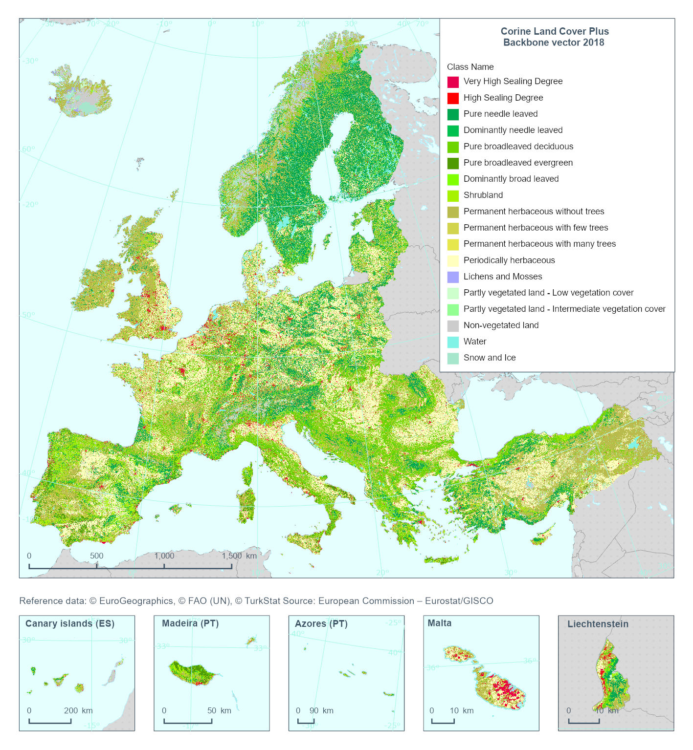
This metadata refers to the 'Corine Land Cover Plus Backbone' (CLCplus Backbone), a spatially detailed, large-scale, Earth Observation-based land cover inventory which is produced by the Copernicus Land Monitoring Service (CLMS). The CLCplus Backbone vector is a land cover map that contains vector polygon geometries (minimum mapping unit: 0.5 ha; minimum mapping width: 20 m) and is based on Sentinel satellite time series and a combination of existing reference datasets for geometries containing transportation and hydrological networks. Each polygon represents aggregated landscape objects and contains their dominant land cover among the 18 basic land cover classes. See polygon class codes in the additional information section. In addition, polygons are enriched with land cover fractions from the CLCplus Backbone raster as well as aggregated attributes based on other CLMS and Copernicus products (e.g. topography).
CLCplus Backbone vector is an independent product and its thematic and geometric contents differ from CLCplus Backbone raster and Corine Land Cover.
The CLCplus Backbone vector is available for the 2018 reference year.
Simple
Identification info
-
Date (Creation)
- 2022-03-07
-
Date (Publication)
- 2024-11-30
-
Edition
-
01.00
-
Citation identifier
- copernicus_v_3035_20_m_CLCplus-backbone_p_2018_v01_r00
Identifier
- Point of contact
-
Organisation Individual Electronic mail address Website Role European Commission
OwnerCopernicus Land Monitoring Service
CustodianEuropean Environment Agency
PublisherCopernicus Land Monitoring Service helpdesk
Point of contact
-
Spatial representation type
-
Vector
Spatial resolution
-
Spatial resolution
- 20 m
Spatial resolution
Equivalent scale
-
Denominator
- 20
-
Topic category
-
-
Environment
-
Imagery base maps earth cover
-
Extent
))
Temporal extent
-
Time period
- 2018-04-01 2018-10-30
-
Maintenance and update frequency
-
As needed
- GEMET - INSPIRE themes, version 1.0
-
-
Land cover
-
- Continents, countries, sea regions of the world.
-
-
United Kingdom
-
EEA38 (from 2020)
-
- GEMET
-
-
land cover
-
land
-
Resource constraints
-
Access constraints
-
Other restrictions
-
Other constraints
- no limitations to public access
Resource constraints
-
Use constraints
-
Other restrictions
-
Other constraints
-
The Copernicus component is governed by Regulation (EU) No 2021/696 of the European Parliament and of the Council of 28 April 2021 establishing the Union Space Programme and the European Union Agency for the Space Programme and repealing Regulations (EU) No 912/2010, (EU) No 1285/2013 and (EU) No 377/2014 and Decision No 541/2014/EU. Within the Copernicus component, a portfolio of land monitoring activities has been delegated by the European Union to the European Environment Agency (EEA) and the DG Joint Research Centre of the European Commission.
The Copernicus land monitoring products and services are made available on a principle of full, open and free access, as established by the Commission Delegated Regulation (EU) No 1159/2013 of 12 July 2013.
Free, full and open access to the products and services of the Copernicus Land Monitoring Service is made on the conditions that:
1. When distributing or communicating Copernicus Land Monitoring Service products and services (data, software scripts, web services, user and methodological documentation and similar) to the public, users shall inform the public of the source of these products and services.
2. Where the Copernicus Land Monitoring Service products and services have been adapted or modified by the user, the user shall clearly state this.
3. Users shall make sure not to convey the impression to the public that the user's activities are officially endorsed by the European Union.
-
Language
- English
-
Character encoding
-
UTF8
-
Additional Information
-
Polygon class codes:
11: Very High Sealing Degree
12: High Sealing Degree
21: Woody - needle leaved trees
21: Pure needle leaved
22: Dominantly needle leaved
31: Pure broadleaved deciduous
32: Pure broadleaved evergreen
33: Dominantly broad leaved
40: Shrubland
51: Permanent herbaceous without trees
52: Permanent herbaceous with few trees
53: Permanent herbaceous with many trees
60: Periodically herbaceous
70: Lichens and mosses
81: Partly vegetated land - Low vegetation cover
82: Partly vegetated land - Intermediate vegetation cover
90: Non-vegetated land
100: Water
110: Snow and ice
Distribution Information
Data quality info
-
Hierarchy level
-
Dataset
Report
Result
-
Title
- Commission Regulation (EU) No 1089/2010 of 23 November 2010 implementing Directive 2007/2/EC of the European Parliament and of the Council as regards interoperability of spatial data sets and services
-
Date (Publication)
- 2010-12-08
-
Explanation
-
See the referenced specification
Report
-
Name of measure
-
Minimum Mapping Unit
Result
-
Value
- 0.5
-
Identifier
- ha
Report
-
Name of measure
-
Minimum Mapping Width
Result
-
Value
- 20
-
Identifier
- m
Resource lineage
-
Statement
-
CLCplus Backbone vector 2018 is a land cover map that contains vector polygon geometries (minimum mapping unit: 0.5. ha; minimum mapping width: 20 m) and is based on image segmentation techniques of Sentinel satellite time series (Softbone) and a combination of existing reference datasets for geometries containing transportation and hydrological networks (Hardbone). Each polygon represents aggregated landscape objects and contains their dominant land cover among the 18 basic land cover classes. In addition, polygons are enriched with land cover fractions from the CLCplus Backbone raster as well as aggregated attributes based on other CLMS and Copernicus products (e.g. topography).
Input data:
1) Softbone: landscape objects obtained from image segmentation techniques of Sentinel-2 L2A data acquired from 2018-04-01 to 2018-10-31.
2) Hardbone: persistent linear landscape objects such as transportation network (i.e. roads, railways) and hydrological waterways (i.e. rivers, lakes, canals) from several external sources (e.g. Open Street Map, CLMS EU-Hydro river and canal network, Water Information System for Europe (WISE) surface waterbody lines, national/regional road and hydrology data).
Processing and Attributes:
1) Landscape objects are generated by combining two levels of objects - level 1 and level 2 objects - so called “Hardbone” and “Softbone”, respectively. Hardbone represents a geometric skeleton of persistent linear landscape objects such as transportation network (i.e. roads, railways) and hydrological waterways (i.e. rivers, lakes, canals), which comprises of various line vector data. Softbone further delineates landscape objects in a controlled automatic manner based on the image segmentation technique, which generates landscape object polygons by their spectral response and variation throughout a year within the frame of Hardbone.
2) Each polygon is assigned with its dominant land cover class (based on majority rule) and the areal fractions (in percent of the total area of the respective polygon) of the three most abundant underlying CLCplus Backbone raster 2018 classes. In addition, CLCplus Backbone vector 2018 is enriched with 58 attributes derived from other CLMS and Copernicus products: CLMS Urban Atlas, CLMS Riparian Zones, CLMS Coastal Zones, CLMS Tree Cover Density, CLMS Imperviousness Density, CLMS Water and Wetness, CLMS High-Resolution Vegetation Phenology and Productivity (HR-VPP), CEMS European Forest Fire Information System (EFFIS) and Copernicus DEM 10m.
Postprocessing:
Steps applied comprise 1) smoothing of Softbone geometries, 2) reintroduction of Hardbone lines, 3) snapping vertices, 4) cleaning the remaining MMU errors and topological consistency (gaps and overlaps).
Changes to previous release:
Not available
-
Hierarchy level
-
Dataset
Reference System Information
Reference System Information
-
Code
- EPSG:3035
-
Maintenance and update frequency
Metadata
-
Metadata identifier
- d45d5114-fb86-4265-9c5a-a7225a511f7c
-
Language
- English
-
Character encoding
-
UTF8
- Contact
-
Organisation Individual Electronic mail address Website Role European Environment Agency
Point of contact
Type of resource
-
Resource type
-
Dataset
-
Date info (Creation)
- 2024-11-05T15:54:20.599242Z
-
Date info (Revision)
- 2025-10-09T11:16:38.958379Z
Metadata standard
-
Title
-
ISO 19115/19139
-
Edition
-
1.0
)))