 EEA geospatial data catalogue
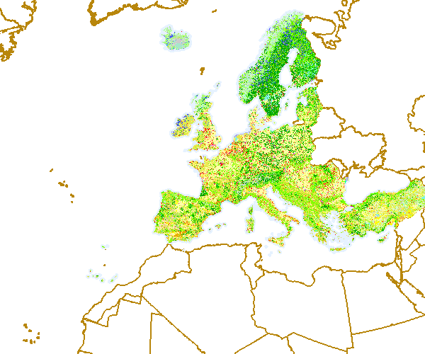
Corine Land Cover 2000 (raster 100m) - version 16, Apr. 2012
With the help of CLC data it is possible to provide support for protecting ecosystems, halting the loss of biological diversity, tracking the impacts of climate change, assessing developments in agriculture and implementing the EU Water Framework Directive. CLC data is an important data set for the implementation of key priority areas of the Sixth Environment Action Programme of the European Community. CLC data can show, for instance, where fragmentation of the landscape by roads and other infrastructure is worsening and thus increasing the risk that ecosystems can no longer connect with each other, putting the survival of their flora and fauna in danger. In the agricultural field CLC data can highlight where major structural changes are continuing or intensifying, such as the conversion of pasture to arable land, expansion or reduction in the area of fallow land and land taken out of production ('set aside'), or the abandonment of farming altogether. CLC serve as input to the EC 'Inspire' (INfrastructure for SPatial InfoRmation in Europe - http://inspire.jrc.it) initiative. This initiative intends to trigger the creation of a European spatial information infrastructure that delivers to the users integrated spatial information services. CLC programme is also a contribution to the Global Monitoring for Environment and Security (GMES http://gmes.info) initiative, run by the European Commission and the European Space Agency, to provide environmental information from a combination of air- and space-based observation systems and in-situ monitoring.
Simple
Identification info
- Date (Publication)
- 2012-06-04
- Date (Creation)
- 2012-06-04
- Edition
-
16
- Citation identifier
- eea_r_3035_100_m_clc-2000_p_2000_v16_r00
- Status
- Obsolete
- Point of contact
-
Organisation Individual Electronic mail address Website Role European Environment Agency
Point of contact European Environment Agency
Custodian
- Spatial representation type
- Grid
Spatial resolution
- Spatial resolution
- 100 m
- Topic category
-
- Environment
- Geoscientific information
Extent
))
Extent
Temporal extent
- Time period
- 2000-01-01 2000-12-31
- Maintenance and update frequency
- Biannually
- GEMET - INSPIRE themes, version 1.0
-
-
Land cover
-
- EEA topics
-
-
Land use
-
Resource constraints
- Use constraints
- Other restrictions
- Other constraints
-
License CC-BY 4.0 ( https://creativecommons.org/licenses/by/4.0/). Copyright holder: European Environment Agency (EEA).
Resource constraints
- Access constraints
- Other restrictions
- Other constraints
- no limitations to public access
- Language
- English
- Character encoding
- UTF8
Data quality info
- Hierarchy level
- Dataset
Report
Result
- Title
-
Commission Regulation (EU) No 1089/2010 of 23 November 2010 implementing Directive 2007/2/EC of the European Parliament and of the Council as regards interoperability of spatial data sets and services
- Date (Publication)
- 2010-12-08
- Explanation
-
See the referenced specification
Resource lineage
- Statement
-
Input data: Corine Land Cover 2000 vector v16 (file geodatabase v10)
Rasterisation using gdal_rasterize from GDAL 1.9.0 command line utilities
- Loop through the list of layers, and generate the layers as defined there, see the shell script [0] and the list of layers (layer_code.list) [1].
- Thereby translating the 3-digit CLC codes (111...999) into grid codes within the 8-bit range (0...44), see clc_legend.csv [2]
- And eventually adding the usual CLC colour table to the generated GeoTIFF, by using a pre-defined vrt file, see [3]
[0]: docs/rasterize.sh
[1]: docs/layer_code.list
[2]: docs/clc_legend.csv
[3]: docs/legend_100.vrt
- Hierarchy level
- Dataset
Reference System Information
Reference System Information
- Code
- EPSG:3035
Metadata
- Metadata identifier
- d815c410-609d-4fb9-9062-94c3f0c14227
- Language
- English
- Character encoding
- UTF8
- Contact
-
Organisation Individual Electronic mail address Website Role European Environment Agency
Point of contact
Type of resource
- Resource type
- Dataset
- Metadata linkage
-
https://sdi.eea.europa.eu/catalogue/srv/api/records/d815c410-609d-4fb9-9062-94c3f0c14227
- Date info (Creation)
- 2012-06-04T14:03:08Z
- Date info (Revision)
- 2025-10-09T11:17:22.240295Z
Metadata standard
- Title
-
ISO 19115/19139
- Edition
-
1.0
)))