 EEA geospatial data catalogue
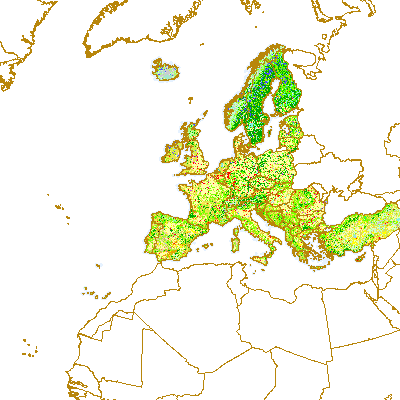
Corine Land Cover 2000 seamless (vector) - version 16, Apr. 2012
CLC00 is one of the datasets produced within the frame the Corine Land Cover programme referring to land cover / land use status of year 2000. The Corine Land Cover (CLC) is an European programme, coordinated by the European Environment Agency (EEA), providing consistent information on land cover and land cover changes across Europe. CLC products are based on the photointerpretation of satellite images by the national teams of the participating countries - the EEA member or cooperating countries. The resulting national land cover inventories are further integrated into a seamless land cover map of Europe. The resulting European database is based on standard methodology and nomenclature with following base parameters: - 44 classes in the hierarchical 3-level Corine nomenclature - minimum mapping unit (MMU) for status layers is 25 hectares - minimum width of linear elements is 100 metres - minimum mapping unit (MMU) for Land Cover Changes (LCC) for change layers is 5 hectares CLC programme provides important data sets supporting the implementation of key priority areas of the Environment Action Programmes of the European Community as protecting ecosystems, halting the loss of biological diversity, tracking the impacts of climate change, assessing developments in agriculture and implementing the EU Water Framework Directive etc.. CLC programme is also a part of the Global Monitoring for Environment and Security (GMES http://gmes.info) initiative, run by the European Commission and the European Space Agency, which will provide environmental information from a combination of air- and space-based observation systems and in-situ monitoring. More about the Corine Land Cover (CLC) programme and datasets can be found at http://www.eea.eu.
Simple
Identification info
- Date (Publication)
- 2012-05-29
- Date (Creation)
- 2012-05-29
- Edition
-
16
- Citation identifier
- eea_v_3035_100_k_clc-2000_p_2000_v16_r00
- Status
- Obsolete
- Point of contact
-
Organisation Individual Electronic mail address Website Role European Environment Agency
Point of contact European Environment Agency
Custodian
- Spatial representation type
- Vector
Spatial resolution
Equivalent scale
- Denominator
- 100000
- Topic category
-
- Environment
- Geoscientific information
Extent
))
Extent
Temporal extent
- Time period
- 2000-01-01T00:00:00 2000-12-31
- Maintenance and update frequency
- Biannually
- GEMET - INSPIRE themes, version 1.0
-
-
Land cover
-
- EEA topics
-
-
Land use
-
Resource constraints
- Use constraints
- Other restrictions
- Other constraints
-
License CC-BY 4.0 ( https://creativecommons.org/licenses/by/4.0/). Copyright holder: European Environment Agency (EEA).
Resource constraints
- Access constraints
- Other restrictions
- Other constraints
- no limitations to public access
- Language
- English
- Character encoding
- UTF8
Data quality info
- Hierarchy level
- Dataset
Report
Result
- Title
-
Commission Regulation (EU) No 1089/2010 of 23 November 2010 implementing Directive 2007/2/EC of the European Parliament and of the Council as regards interoperability of spatial data sets and services
- Date (Publication)
- 2010-12-08
- Explanation
-
See the referenced specification
Resource lineage
- Statement
-
Vector CLC database was provided by National Teams within original CLC1990, I&CLC2000 update and FTSP/CLC2006 update projects. All features in original vector database were classified and digitised based on satellite images with 100 m positional accuracy (according to CLC specifications) and 25 ha minimum mapping unit into the standardized CLC nomenclature (44 CLC classes). European Corine Land Cover seamless DBs represent the final product of European data integration. The process of data integration started when national deliveries have been accepted and the Database Acceptance Report (DBTA) delivered . Delivered national data were produced in local national systems of all participating countries. Each national Coordinate Reference System (CRS) definition had to be known precisely together with its geometric relationship to a standard system in order to accurately transfer all national data into a standard European coordinate reference - ETRS89/LAEA1052. Mostly, the process itself was carried out by global equation-based transformation to ETRS89 (e.g. seven-parameters Bursa-Wolf methods). The accuracy of a particular transformation ranges from centimetres to meters depending on the method and the quality and number of control points available to define the transformation parameters, but, in any case, the accuracy is far above the actual CLC data resolution (for more details see the DBTA reports for particular country). National data, when transformed into the common European reference, are introduced into tiled pan-European structure and as final step seamless dataset is produced. In order to achieve production of the real seamless European database, the integration step includes also harmonization of database along country borders. It consists from edge-matching of land cover polygons from the national databases across national borders done by a verification / re-interpretation of the satellite images in the border regions (2 km wide strip along borders). The satellite images from IMAGE2000. CLC90, CHA00 and CLC00 database were harmonized this way, but the order to priority was as following: CLC2000, both geometric and thematic adaptations of all polygons in a 2 km strip along national boundary lines; CHA00 database to ensure that changes in CLC2000 are consistent with the change database; corrected CLC90 (if provided by the MS); corrections were focused to geometric adaptations in semi-automatical way based on CLC00 and CHA00 databases. Note: Some artificial lines (dividing polygons with the same code) can be still present in database due to technical constraints of current ArcGIS technology, but has no impact for dataset contents and can be dissolved for data extracts.
Changes:
Vector CLC database was provided by National Teams within original CLC1990, I&CLC2000 update and FTSP/CLC2006 update projects. All features in original vector database were classified and digitised based on satellite images with 100 m positional accuracy (according to CLC specifications) and 25 ha minimum mapping unit into the standardized CLC nomenclature (44 CLC classes). European Corine Land Cover seamless DBs represent the final product of European data integration. The process of data integration started when national deliveries have been accepted and the Database Acceptance Report (DBTA) delivered . Delivered national data were produced in local national systems of all participating countries. Each national Coordinate Reference System (CRS) definition had to be known precisely together with its geometric relationship to a standard system in order to accurately transfer all national data into a standard European coordinate reference - ETRS89/LAEA1052. Mostly, the process itself was carried out by global equation-based transformation to ETRS89 (e.g. seven-parameters Bursa-Wolf methods). The accuracy of a particular transformation ranges from centimetres to meters depending on the method and the quality and number of control points available to define the transformation parameters, but, in any case, the accuracy is far above the actual CLC data resolution (for more details see the DBTA reports for particular country). National data, when transformed into the common European reference, are introduced into tiled pan-European structure and as final step seamless dataset is produced. In order to achieve production of the real seamless European database, the integration step includes also harmonization of database along country borders. It consists from edge-matching of land cover polygons from the national databases across national borders done by a verification / re-interpretation of the satellite images in the border regions (2 km wide strip along borders). The satellite images from IMAGE2000. CLC90, CHA00 and CLC00 database were harmonized this way, but the order to priority was as following: CLC2000, both geometric and thematic adaptations of all polygons in a 2 km strip along national boundary lines; CHA00 database to ensure that changes in CLC2000 are consistent with the change database; corrected CLC90 (if provided by the MS); corrections were focused to geometric adaptations in semi-automatical way based on CLC00 and CHA00 databases. Note: Some artificial lines (dividing polygons with the same code) can be still present in database due to technical constraints of current ArcGIS technology, but has no impact for dataset contents and can be dissolved for data extracts. CHANGES:Version 16 (V6) (04/2012) Production date: April 15th, 2012 Release history: V6: 04/2012 - Upgraded version - Erroneously classiffied polygon on DE/BE boundary has been repaired. - Reprojected CLC00 data for Malta are included.
V5: 07/2011 - Upgraded version - Sea buffer between clc00 and clc06 harmonized - Contains data for 39 countries
V4: 10/2010 - Upgraded version - Provided as seamless Geodatabase in ETRS89/LAEA1052 CRS - Madeira Islands, Switzerland, Iceland included - Sea buffer (25km) improved so they are consistent across all CLC layers - No-data buffer (code 999) outside of valid data area was deleted. Value 999 is acepted only for Andorra area - Small gaps identified in v3 were repaired - Remaining neigbouring polygons with the same code, as identified in v3, were resolved - Contains data for 39 countries
V3: 04/2010 - Upgraded version - provided as seamless Geodatabase in ETRS89/LAEA1052 CRS - Türkiye included - Sea buffer (25km) introduced
V2: 10/2009 - Upgraded version - tile borders artefacts reported by users corrected - new tiling introduced based on ETRS89/LAEA1052 grid - Norway included
V1: 08/2005 - First release - in A/I Librarian in ETRS89 CRS - tiling follows IMAGE2000 tiling
- Hierarchy level
- Dataset
Reference System Information
Reference System Information
- Code
- EPSG:3035
Metadata
- Metadata identifier
- fa92e450-c5cb-4796-b77c-ddb248203672
- Language
- English
- Character encoding
- UTF8
- Contact
-
Organisation Individual Electronic mail address Website Role European Environment Agency
Point of contact
Type of resource
- Resource type
- Dataset
- Metadata linkage
-
https://sdi.eea.europa.eu/catalogue/srv/api/records/fa92e450-c5cb-4796-b77c-ddb248203672
- Date info (Creation)
- 2012-05-29T14:22:56Z
- Date info (Revision)
- 2025-10-09T11:24:36.581943Z
Metadata standard
- Title
-
ISO 19115/19139
- Edition
-
1.0
)))