 EEA geospatial data catalogue
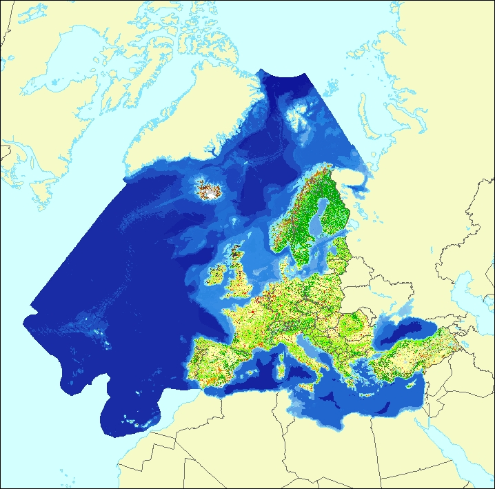
Ecosystem types of Europe 2012 - Full map (marine and terrestrial habitats) - version 3 revision 1, Feb. 2019
The data set aims to contribute to a better biological characterization of marine and terrestrial ecosystems across Europe (EEA-39). As such it represents probabilities of EUNIS (EUropean Nature Information System) habitat presence at Level 2 for terrestrial habitats and corresponding Level 3 for marine habitats (including information on sea ice coverage).
The map combines spatially explicit data on marine bathymetry and sea-bed and land cover information with non-spatially referenced habitat information of the EUNIS classification. The objective of the data set produced by EEA and its Topic Centres ETC/BD and ETC/ULS is to improve the biological description of marine and land based ecosystem types and their spatial distribution across Europe.
Since it is partly based on non-spatial explicit mapping the spatial and thematic accuracy is not of same quality as delineated maps. For terrestrial habitats the geometric and thematic accuracy is estimated in the reliability map 2012 v3.1 as secondary product.
The work supports Target 2 Action 5 of the implementation of the EU Biodiversity Strategy to 2020, established to achieve the Aichi targets of the Convention of Biological Diversity (CBD). It further addresses the MAES process (Mapping and Assessing of Ecosystems and their Services). The MAES ecosystem typology differentiates three levels and with certain differences follows the EUNIS classification: whereas MAES level 2 the proposal corresponds to EUNIS level 1, MAES level 3 follows closely the EUNIS level 2. For terrestrial habitats a representation of MAES level 2 is contained in the reliability map as secondary product.
Simple
Identification info
- Date (Creation)
- 2018-12-31
- Date (Publication)
- 2019-02-26
- Edition
-
03.01
- Citation identifier
- eea_r_3035_100_m_ecosystem-types-full_p_2012_v03_r01
- Citation identifier
- DAT-146-en
- Point of contact
-
Organisation Individual Electronic mail address Website Role European Environment Agency
Point of contact European Environment Agency
Custodian
- Spatial representation type
- Grid
Spatial resolution
- Spatial resolution
- 100 m
- Topic category
-
- Biota
- Environment
- Oceans
- Inland waters
Extent
))
Extent
Temporal extent
- Time period
- 2012-01-01 2012-12-31
- Maintenance and update frequency
- As needed
- EEA topics
-
-
Biodiversity
-
- GEMET - INSPIRE themes, version 1.0
-
-
Oceanographic geographical features
-
Sea regions
-
Habitats and biotopes
-
Land cover
-
- Continents, countries, sea regions of the world.
-
-
EEA39
-
- GEMET
-
-
habitat
-
riparian zone
-
ecosystem type
-
ecosystem
-
environmental policy
-
- EEA Management Plan
-
-
2018 1.7.5
-
Resource constraints
- Use constraints
- Other restrictions
- Other constraints
-
License CC-BY 4.0 ( https://creativecommons.org/licenses/by/4.0/). Copyright holder: European Environment Agency (EEA).
Resource constraints
- Access constraints
- Other restrictions
- Other constraints
- no limitations to public access
Associated resource
- Association Type
- Revision Of
- Metadata Reference
- Language
- English
Distribution Information
- Distribution format
-
-
GeoTIFF
-
- OnLine resource
-
Direct download
- OnLine resource
-
Ecosystem type map (all classes) - static map
Data quality info
- Hierarchy level
- Dataset
Report
Result
- Title
- Commission Regulation (EU) No 1089/2010 of 23 November 2010 implementing Directive 2007/2/EC of the European Parliament and of the Council as regards interoperability of spatial data sets and services
- Date (Publication)
- 2010-12-08
- Explanation
-
See the referenced specification
Resource lineage
- Statement
-
The data set is a composition of two independent but complementary data sets:
a) marine part (elaborated by EEA and ETC/ULS) – Ecosystem Type Map 2012 v3.1 - Marine habitats
b) terrestrial part (elaborated by EEA and ETC/BD) – Ecosystem Type Map 2012 v3.1 - Terrestrial habitats
The two parts have been merged into a new data set by the “Mosaic To New Raster” tool.
Information about the lineage of these two component datasets is provided within their corresponding metadata as well as on the ETC/BD Technical Paper 11/2018 "Ecosystem Type Map v3.1-Terrestrial and marine ecosystems" provided with the dataset (Ecosystem_mapping_v3_1.pdf).
- Hierarchy level
- Dataset
Reference System Information
Reference System Information
- Code
- EPSG:3035
Metadata
- Metadata identifier
- faff2281-1fca-4548-89d8-c8ec0c507bc7
- Language
- English
- Character encoding
- UTF8
- Contact
-
Organisation Individual Electronic mail address Website Role European Environment Agency
Point of contact
Type of resource
- Resource type
- Dataset
- Metadata linkage
-
https://sdi.eea.europa.eu/catalogue/srv/api/records/faff2281-1fca-4548-89d8-c8ec0c507bc7
- Date info (Creation)
- 2019-02-22T12:50:20Z
- Date info (Revision)
- 2025-10-09T11:24:43.10991Z
Metadata standard
- Title
-
ISO 19115/19139
- Edition
-
1.0
)))