 EEA geospatial data catalogue
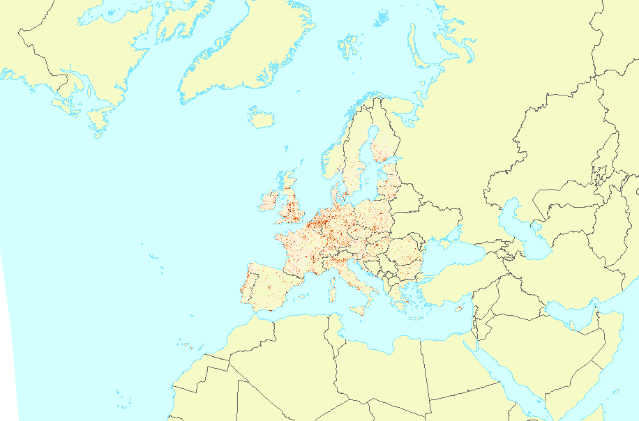
Weighted Urban Proliferation (WUP) 2009 (LEAC Grid), Nov. 2016
The new urban sprawl metric, named "Weighted Urban Proliferation“ (WUP) is based on the following definition of urban sprawl: the more area is built over in a given landscape (amount of built-up area) and the more dispersed this built-up area is in the landscape (spatial configuration), and the higher the uptake of built-up area per inhabitant or job (lower utilisation intensity in the built-up area), the higher the degree of urban sprawl.
Weighted Urban Proliferation (WUP) metric has three components: the percentage of built-up areas (PBA), the dispersion of the built-up areas (DIS), and land uptake per person (LUP).
Simple
Identification info
- Date (Publication)
- 2016-12-16
- Date (Creation)
- 2016-11-30
- Edition
-
02.00
- Citation identifier
- eea_r_3035_1_km_wup2009_p_2008-2011_v02_r00
- Point of contact
-
Organisation Individual Electronic mail address Website Role European Environment Agency
Point of contact
- Spatial representation type
- Grid
Spatial resolution
- Spatial resolution
- 1 km
- Topic category
-
- Environment
Extent
))
Extent
Temporal extent
- Time period
- 2008-01-01 2011-12-31
- Maintenance and update frequency
- Unknown
- GEMET - INSPIRE themes, version 1.0
-
-
Population distribution — demography
-
Land use
-
Buildings
-
- GEMET
-
-
urbanisation
-
built environment
-
built-up area
-
urban sprawl
-
- Continents, countries, sea regions of the world.
-
-
Germany
-
Austria
-
Finland
-
Iceland
-
Lithuania
-
Slovakia
-
Hungary
-
Czechia
-
Poland
-
Belgium
-
Spain
-
Liechtenstein
-
United Kingdom
-
France
-
Italy
-
Greece
-
Slovenia
-
Ireland
-
Switzerland
-
Netherlands
-
Luxembourg
-
Croatia
-
Sweden
-
Latvia
-
Portugal
-
Estonia
-
Norway
-
Romania
-
Bulgaria
-
Denmark
-
- EEA topics
-
-
Buildings and construction
-
Land use
-
Urban sustainability
-
Resource constraints
- Access constraints
- Other restrictions
- Other constraints
- no limitations to public access
Resource constraints
- Use constraints
- Other restrictions
- Other constraints
-
License CC-BY 4.0 ( https://creativecommons.org/licenses/by/4.0/). Copyright holder: European Environment Agency (EEA).
- Language
- English
- Character encoding
- UTF8
Distribution Information
- Distribution format
-
-
GeoTIFF
-
- OnLine resource
-
https://sdi.eea.europa.eu/webdav/datastore/public/eea_r_3035_1_km_wup2009_p_2008-2011_v02_r00/
- OnLine resource
-
Direct download (Eionet authentication)
- OnLine resource
-
https://land.discomap.eea.europa.eu/arcgis/rest/services/Urban_Sprawl/WUP_1km_2009y/MapServer
- OnLine resource
-
0
Weighted Urban Profileration (WUP) LEAC 2009
Data quality info
- Hierarchy level
- Dataset
Report
Result
- Title
-
Commission Regulation (EU) No 1089/2010 of 23 November 2010 implementing Directive 2007/2/EC of the European Parliament and of the Council as regards interoperability of spatial data sets and services
- Date (Publication)
- 2010-12-08
- Explanation
-
See the referenced specification
Resource lineage
- Statement
-
The mapping computation steps are:
1) A built-up areas were selected from the raster High Resolution Layer – Imperviousness Degree (HRL IMD). Only these pixels, where IMD value >= 30% were selected as built-up.
2) The built-up areas layer together with the reference units layer were inputs to the computations (NUTS0, NUTS2 and 1km LEAC grid were used as the reference layers)
3) WUP values were computed by equations described in https://www.wsl.ch/fileadmin/user_upload/WSL/Services_Produkte/Software_Apps/USM/USM-Toolset-User-Manual.pdf (pages 2 and 17-18 )
4) Newly developed tool called “Urban Sprawl Metric Tool” is available on the https://www.wsl.ch/en/services-produkte/urban-sprawl-metrics-tool-usm/
- Hierarchy level
- Dataset
Reference System Information
Reference System Information
- Code
- EPSG:3035
Metadata
- Metadata identifier
- 02580a02-cb8d-4474-95bb-4fdb30a50119
- Language
- English
- Character encoding
- UTF8
- Contact
-
Organisation Individual Electronic mail address Website Role European Environment Agency
Point of contact
Type of resource
- Resource type
- Dataset
- Metadata linkage
-
https://sdi.eea.europa.eu/catalogue/srv/api/records/02580a02-cb8d-4474-95bb-4fdb30a50119
- Date info (Creation)
- 2018-04-04T14:15:17Z
- Date info (Revision)
- 2025-10-09T10:34:17.815516Z
Metadata standard
- Title
-
ISO 19115/19139
- Edition
-
1.0
)))