 EEA geospatial data catalogue
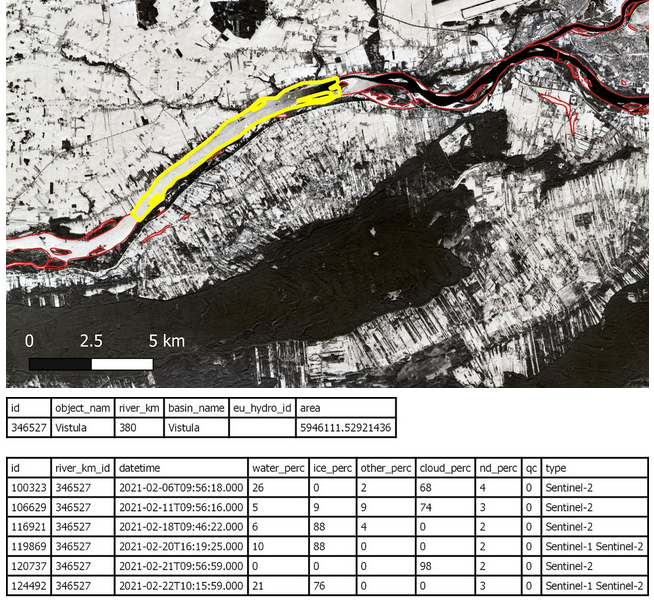
High Resolution Snow and Ice Monitoring: Aggregated River and Lake Ice Extent (ARLIE)
The Aggregated River and Lake Ice Extent (ARLIE) product is a spatially aggregated information on surface water conditions of rivers and lakes. ARLIE information is stored in a geodatabase, enriched every day from the different River and Lake Ice Extent products (RLIE S1, RLIE S2, RLIE S1+S2) for the entire EEA38 and the United Kingdom. It provides percent coverage of snow-covered or snow-free ice on lakes and on 10 km river sections described by the EU-HYDRO river and lake network database.
The ARLIE data is stored in a PostGIS persistent geodatabase. They can be retrieved by using a specific REST API. Users can query ice sheet summary information of river segments and lakes (ARLIE statistics) together with the geometry and caracteristics of the features on which these statistics were estimated. All geometry features are delivered in the ETRS89 LAEA (EPSG:3035) coordinate reference system.
ARLIE is one of the products of the pan-European High-Resolution Snow and Ice service (HR-S&I), which are provided at high spatial resolution from the Sentinel-2 and Sentinel-1 constellations data from September 1, 2016 onwards.
Simple
Identification info
- Date (Publication)
- 2021-07-01
- Edition
-
01.00
- Citation identifier
- copernicus_v_3035_50_k_hrsi-arlie_p_2016-now_v01_r00
- Citation identifier
- DAT-244-en
- Point of contact
-
Organisation Individual Electronic mail address Website Role European Commission
Owner Copernicus Land Monitoring Service
Custodian European Environment Agency
Publisher Copernicus Land Monitoring Service helpdesk
Point of contact
- Spatial representation type
- Vector
Spatial resolution
Equivalent scale
- Denominator
- 50000
Extent
))
Temporal extent
- Time period
- 2016-09-01
- Maintenance and update frequency
- Continual
- Continents, countries, sea regions of the world.
-
-
United Kingdom
-
EEA38 (from 2020)
-
- Temporal resolution
-
-
Irregular
-
- EEA Management Plan
-
-
2020 3.6.7
-
Resource constraints
- Access constraints
- Other restrictions
- Other constraints
- no limitations to public access
Resource constraints
- Use constraints
- Other restrictions
- Other constraints
-
The Copernicus component is governed by Regulation (EU) No 2021/696 of the European Parliament and of the Council of 28 April 2021 establishing the Union Space Programme and the European Union Agency for the Space Programme and repealing Regulations (EU) No 912/2010, (EU) No 1285/2013 and (EU) No 377/2014 and Decision No 541/2014/EU. Within the Copernicus component, a portfolio of land monitoring activities has been delegated by the European Union to the European Environment Agency (EEA) and the DG Joint Research Centre of the European Commission.
The Copernicus land monitoring products and services are made available on a principle of full, open and free access, as established by the Commission Delegated Regulation (EU) No 1159/2013 of 12 July 2013.
Free, full and open access to the products and services of the Copernicus Land Monitoring Service is made on the conditions that:
1. When distributing or communicating Copernicus Land Monitoring Service products and services (data, software scripts, web services, user and methodological documentation and similar) to the public, users shall inform the public of the source of these products and services.
2. Where the Copernicus Land Monitoring Service products and services have been adapted or modified by the user, the user shall clearly state this.
3. Users shall make sure not to convey the impression to the public that the user's activities are officially endorsed by the European Union.
- Language
- English
- Character encoding
- UTF8
Distribution Information
- Distribution format
-
-
Postgis
-
- OnLine resource
-
Product Information & Technical Documentation
Data quality info
- Hierarchy level
- Dataset
Report
Result
- Date (Publication)
- Explanation
-
See the referenced specification
Resource lineage
- Statement
-
Input data for the ARLIE are the WIC S1, the WIC S2 and the WIC S1+S2.
- Hierarchy level
- Dataset
Reference System Information
Reference System Information
- Code
- EPSG:3035
- Maintenance and update frequency
Metadata
- Metadata identifier
- 219a6cd4-edfe-4982-8470-39b60421ed74
- Language
- English
- Character encoding
- UTF8
- Contact
-
Organisation Individual Electronic mail address Website Role European Environment Agency
Point of contact
Type of resource
- Resource type
- Dataset
- Metadata linkage
-
https://sdi.eea.europa.eu/catalogue/srv/api/records/219a6cd4-edfe-4982-8470-39b60421ed74
- Date info (Creation)
- 2022-01-06T16:08:19.776Z
- Date info (Revision)
- 2025-10-09T10:40:29.523792Z
Metadata standard
- Title
-
ISO 19115/19139
- Edition
-
1.0
)))