 EEA geospatial data catalogue
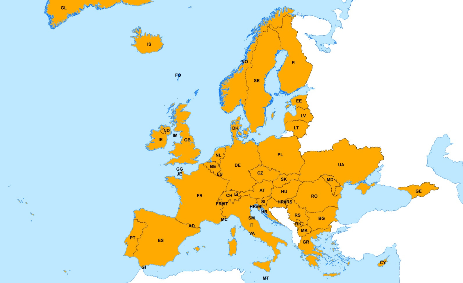
EuroGlobalMap (full European coverage) - version 10.0, Sep. 2017
EuroGlobalMap is a topographic dataset that covers the EU, Andorra, Croatia, Faroe Islands, Georgia, Greenland, Iceland, Kosovo (UNSCR 1244/99), Liechtenstein, North Macedonia, Moldova, Monaco, Norway, San Marino, Serbia, Switzerland, Ukraine and Vatican at the scale 1:1 Million. It is produced in cooperation by the National Mapping Agencies of Europe, using official national databases.
Thematic layers: Administrative Boundaries, Water network, Transport Network, Settlements and Named Locations.
This metadata refers to the version 10 of EGM of full Europe. For more information about the data product specifications and changes with respect to the previous version of this dataset (EGM v9), please refer to the documents EGM_Specification_v10.pdf, EGM_UserGuide_v10.pdf and EGM_Changes_v10.pdf provided with the dataset (DOCUMENTS.zip).
This metadata has been slightly adapted from the original metadata file provided by EuroGeographics and is to be used only for internal EEA purposes. For reference, the metadata file created by EuroGeographics is provided together with the dataset ("EGM_v10_Metadata.xsl" within the "METADATA.zip")
Simple
Identification info
- Date (Creation)
- 2016-12-31
- Edition
-
10.0
- Citation identifier
- eurogeographics_v_4258_1_mio_egm-europe_i_1998-2016_v10_r0
- Spatial representation type
- Vector
Spatial resolution
Equivalent scale
- Denominator
- 1000000
- Topic category
-
- Location
- Boundaries
- Inland waters
- Transportation
- Society
Extent
Temporal extent
- Time period
- 1998-01-01 2016-01-30
Extent
))
- Maintenance and update frequency
- Annually
- GEMET - INSPIRE themes, version 1.0
-
-
Administrative units
-
Statistical units
-
Geographical names
-
Transport networks
-
Population distribution — demography
-
- Continents, countries, sea regions of the world.
-
-
Monaco
-
Faeroe Islands
-
San Marino
-
Kosovo (UNSCR 1244/99)
-
Vatican
-
Moldova
-
Serbia
-
Andorra
-
Greenland
-
Gibraltar
-
EFTA4
-
EU28 (2013-2020)
-
Ukraine
-
North Macedonia
-
- GEMET
-
-
route planning
-
international watercourse
-
administrative boundary
-
national boundary
-
geo-referenced data
-
lake
-
transportation
-
hydrography
-
geography
-
railway network
-
dam
-
railway station
-
tidal water
-
river
-
maritime transport
-
harbour
-
glacier
-
highway
-
artificial lake
-
estuary
-
waterway
-
drainage water
-
data base
-
road
-
coast
-
high-speed railway
-
surface water
-
airport
-
Resource constraints
- Access constraints
- Other restrictions
Resource constraints
- Use constraints
- Other restrictions
- Other constraints
-
EGM is available as Open Data.
You may use EuroGlobalMap and the associated data, on condition that you acknowledge the intellectual rights and the source of the Product, by including the following attribution statement:
“This product includes Intellectual Property from European National Mapping and Cadastral Authorities and is licensed on behalf of these by EuroGeographics. Original product is available for free at www.eurogeographics.org Terms of the licence available https://eurogeographics.org/services/open-data/topographic-data/”.
In case the long statement above cannot be used, you may use the following short form:
“© EuroGeographics. Original product is available for free at www.eurogeographics.org Terms of licence available at https://eurogeographics.org/services/open-data/topographic-data/”.
You must include the same acknowledgement requirement in any sub-licences that you grant, and a requirement that any further sub-licences do the same.
The full content of the EuroGeographics Open Data License is available on: https://www.mapsforeurope.org/terms-conditions.
Small scale applications only, map scale 1:500.000 - 1: 2.000.000, not to be used for navigation.
- Language
- bul
- Character encoding
- UTF8
- Language
- cze
- Character encoding
- UTF8
- Language
- dan
- Character encoding
- UTF8
- Language
- dut
- Character encoding
- UTF8
- Language
- English
- Character encoding
- UTF8
- Language
- est
- Character encoding
- UTF8
- Language
- fin
- Character encoding
- UTF8
- Language
- fre
- Character encoding
- UTF8
- Language
- ger
- Character encoding
- UTF8
- Language
- gre
- Character encoding
- UTF8
- Language
- hrv
- Character encoding
- UTF8
- Language
- hun
- Character encoding
- UTF8
- Language
- ice
- Character encoding
- UTF8
- Language
- ita
- Character encoding
- UTF8
- Language
- lav
- Character encoding
- UTF8
- Language
- lit
- Character encoding
- UTF8
- Language
- mac
- Character encoding
- UTF8
- Language
- mlt
- Character encoding
- UTF8
- Language
- nor
- Character encoding
- UTF8
- Language
- pol
- Character encoding
- UTF8
- Language
- por
- Character encoding
- UTF8
- Language
- rum
- Character encoding
- UTF8
- Language
- slo
- Character encoding
- UTF8
- Language
- slv
- Character encoding
- UTF8
- Language
- spa
- Character encoding
- UTF8
- Language
- srp
- Character encoding
- UTF8
- Language
- swe
- Character encoding
- UTF8
- Language
- bos
- Character encoding
- UTF8
- Language
- geo
- Character encoding
- UTF8
- Language
- ukr
- Character encoding
- UTF8
Distribution Information
- Distribution format
-
-
GDB
-
SHP
-
- OnLine resource
-
Direct download (Eionet authentication)
- OnLine resource
-
Direct download (Eionet authentication)
Data quality info
- Hierarchy level
- Dataset
Report
Result
- Title
-
EuroGlobalMap: Specifications and Data Catalogue for the release 10.0
- Date (Publication)
- 2017-01-31
- Explanation
-
See the referenced specification and quality reports provided together with the dataset.
- Pass
- true
Report
Result
- Title
-
Commission Regulation (EU) No 1089/2010 of 23 November 2010 implementing Directive 2007/2/EC of the European Parliament and of the Council as regards interoperability of spatial data sets and services
- Date (Publication)
- 2010-12-08
- Explanation
-
See the referenced specification
Resource lineage
- Statement
-
See EGM_Lineage_v10.pdf under "METADATA.zip" provided with the dataset.
- Hierarchy level
- Dataset
Reference System Information
Reference System Information
- Code
- EPSG:4258
Metadata
- Metadata identifier
- 27812b75-404e-476e-8a21-07df0122d764
- Language
- English
- Character encoding
- UTF8
- Contact
-
Organisation Individual Electronic mail address Website Role European Environment Agency
Point of contact
Type of resource
- Resource type
- Dataset
- Metadata linkage
-
https://sdi.eea.europa.eu/catalogue/srv/api/records/27812b75-404e-476e-8a21-07df0122d764
- Date info (Creation)
- 2018-07-18T08:27:30Z
- Date info (Revision)
- 2025-10-09T10:41:44.205975Z
Metadata standard
- Title
-
ISO 19115/19139
- Edition
-
1.0
)))