 EEA geospatial data catalogue
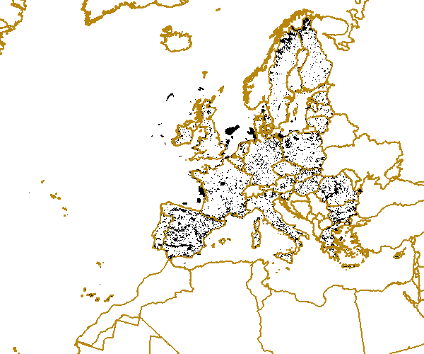
Natura 2000 100 m (raster) - end 2011
This dataset was built from the original Natura 2000 vector. The raster grid is aligned with the EEA reference grid GeoTIFFs generated by GRASS, according to the GeoTIFF Revision 1.0 specifications at https://www.ogc.org/publications/standard/geotiff/. The information displays if there is or not Natura 2000 sites under each specific pixel zone .
Simple
Identification info
- Date (Creation)
- 2012-06-01
- Citation identifier
- eea_r_3035_100_m_nature-sites_p_2011_V01_r00
- Status
- Obsolete
- Point of contact
-
Organisation Individual Electronic mail address Website Role European Environment Agency
Point of contact European Commission
Custodian
- Spatial representation type
- Grid
Spatial resolution
- Spatial resolution
- 100 m
- Topic category
-
- Environment
- Geoscientific information
Extent
))
Extent
Temporal extent
- Time period
- 2011-06-01 2011-10-31
- GEMET - INSPIRE themes, version 1.0
-
-
Protected sites
-
- GEMET
-
-
biodiversity
-
protected area
-
nature conservation
-
- EEA topics
-
-
Biodiversity
-
Resource constraints
- Use constraints
- Other restrictions
- Other constraints
-
License CC-BY 4.0 ( https://creativecommons.org/licenses/by/4.0/).
Resource constraints
- Access constraints
- Other restrictions
- Other constraints
- no limitations to public access
- Language
- English
- Character encoding
- UTF8
Data quality info
- Hierarchy level
- Dataset
Report
Result
- Title
-
Commission Regulation (EU) No 1089/2010 of 23 November 2010 implementing Directive 2007/2/EC of the European Parliament and of the Council as regards interoperability of spatial data sets and services
- Date (Publication)
- 2010-12-08
- Explanation
-
See the referenced specification
Resource lineage
- Statement
-
This dataset was built from the original Natura 2000 vector, public version. The raster grid is aligned with the EEA reference grid GeoTIFFs generated by GRASS, according to the GeoTIFF Revision 1.0 specifications at https://www.ogc.org/publications/standard/geotiff/.
0. The input vector data, from EEA SDI
http://sdi.eea.europa.eu/catalogue/srv/eng/search?uuid=cc3eadf2-fed8-4262-99ef-bd639ade1eb8
1. Rasterisation with GDAL tools (takes ~2 hours)
$ for res in 100 250 1000 ; do
gdal_rasterize Natura2000_End2011.shp Natura2000_End2011_${res}m.tif \
-ot byte -a_nodata 0 -co compress=deflate -co tiled=yes -tr $res $res -tap -burn 1 & done
- Hierarchy level
- Dataset
Reference System Information
Reference System Information
- Code
- EPSG:3035
Metadata
- Metadata identifier
- 28d8bb0d-7194-4451-98d1-382166e8bdb8
- Language
- English
- Character encoding
- UTF8
- Contact
-
Organisation Individual Electronic mail address Website Role European Environment Agency
Point of contact
Type of resource
- Resource type
- Dataset
- Metadata linkage
-
https://sdi.eea.europa.eu/catalogue/srv/api/records/28d8bb0d-7194-4451-98d1-382166e8bdb8
- Date info (Creation)
- 2012-08-06T09:48:11Z
- Date info (Revision)
- 2025-10-09T10:42:10.50364Z
Metadata standard
- Title
-
ISO 19115/19139
- Edition
-
1.0
)))