 EEA geospatial data catalogue
Natura 2000 - 2006 (vector), Jan. 2020
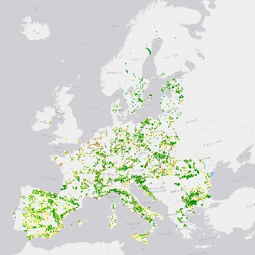
Natura 2000 (N2K) is a network of core breeding and resting sites for rare and threatened species, as well as for some rare natural habitat types which are protected in their own right. It stretches across all EU member states, both on land and at sea. The aim of the network is to ensure the long-term survival of Europe's most valuable and threatened species and habitats that are listed under the Birds Directive and the Habitats Directive.
Previously, in 2015 a selection of N2K grassland-rich sites (chosen from within five grassland habitats types, namely, 6210, 6240, 6250, 6510 and 6520) and covering approx. 160.000 km2 was mapped, including a 2 km buffer to allow for an analysis of pressures and threats. The mapping product offered a detailed LC/LU product applying a hierarchical nomenclature with 62 classes. The selected sites were mapped for both the 2006 and 2012 reference years.
In 2017, to allow for a harmonisation of the nomenclatures applied to the different hot-spot products (Riparian Zones, N2K and the future Coastal Zone product), a revision of the nomenclature was undertaken which resulted in a reduction of classes. The N2K status layer now differentiates 55 thematic LC/LU classes. Due to the revision of the nomenclature the original dataset had to be re-coded (the old dataset is discontinued) and the new dataset, with an increased area, offers currently a LC/LU product covering approximately 630.000 km2.
The production of N2K updates was coordinated by the European Environment Agency (EEA) in the frame of the EU Copernicus programme.
Simple
Identification info
-
Date (Creation)
- 2019-07-19
-
Date (Publication)
- 2019-07-19
-
Date (Revision)
- 2020-01-27
-
Edition
-
02.01
-
Citation identifier
- copernicus_v_3035_10_m_n2k-2006_p_2004-2008_v02_r01
-
Status
-
Obsolete
- Point of contact
-
Organisation Individual Electronic mail address Website Role European Commission
OwnerCopernicus Land Monitoring Service
CustodianEuropean Environment Agency
PublisherCopernicus Land Monitoring Service helpdesk
Point of contact
-
Spatial representation type
-
Vector
Spatial resolution
-
Spatial resolution
- 10 m
-
Topic category
-
-
Environment
-
Imagery base maps earth cover
-
Extent
Temporal extent
-
Time period
- 2004-01-01 2008-12-31
Extent
))
-
Maintenance and update frequency
-
Continual
- GEMET - INSPIRE themes, version 1.0
-
-
Land cover
-
Protected sites
-
- Continents, countries, sea regions of the world.
-
-
Serbia
-
Romania
-
Austria
-
Switzerland
-
Croatia
-
Latvia
-
Ireland
-
Estonia
-
Hungary
-
Poland
-
Denmark
-
Netherlands
-
Portugal
-
Belgium
-
Sweden
-
Greece
-
Slovakia
-
United Kingdom
-
Finland
-
Luxembourg
-
Bulgaria
-
Spain
-
Italy
-
Cyprus
-
Czechia
-
Slovenia
-
Germany
-
France
-
Lithuania
-
- GEMET
-
-
species
-
natural areas protection
-
land use
-
habitat
-
protected area
-
landscape alteration
-
natural area
-
- EEA topics
Resource constraints
-
Access constraints
-
Other restrictions
-
Other constraints
- no limitations to public access
Resource constraints
-
Use constraints
-
Other restrictions
-
Other constraints
-
The Copernicus component is governed by Regulation (EU) No 2021/696 of the European Parliament and of the Council of 28 April 2021 establishing the Union Space Programme and the European Union Agency for the Space Programme and repealing Regulations (EU) No 912/2010, (EU) No 1285/2013 and (EU) No 377/2014 and Decision No 541/2014/EU. Within the Copernicus component, a portfolio of land monitoring activities has been delegated by the European Union to the European Environment Agency (EEA) and the DG Joint Research Centre of the European Commission.
The Copernicus land monitoring products and services are made available on a principle of full, open and free access, as established by the Commission Delegated Regulation (EU) No 1159/2013 of 12 July 2013.
Free, full and open access to the products and services of the Copernicus Land Monitoring Service is made on the conditions that:
1. When distributing or communicating Copernicus Land Monitoring Service products and services (data, software scripts, web services, user and methodological documentation and similar) to the public, users shall inform the public of the source of these products and services.
2. Where the Copernicus Land Monitoring Service products and services have been adapted or modified by the user, the user shall clearly state this.
3. Users shall make sure not to convey the impression to the public that the user's activities are officially endorsed by the European Union.
Associated resource
-
Association Type
-
Revision Of
-
Metadata Reference
-
Language
- English
-
Character encoding
-
UTF8
-
Additional Information
-
Spatial Resolution information: The Minimum Mapping Width is 10 m
Distribution Information
Data quality info
-
Hierarchy level
-
Dataset
Report
Result
-
Title
-
Commission Regulation (EU) No 1089/2010 of 23 November 2010 implementing Directive 2007/2/EC of the European Parliament and of the Council as regards interoperability of spatial data sets and services
-
Date (Publication)
- 2010-12-08
-
Explanation
-
See the referenced specification
Resource lineage
-
Statement
-
Generation of a LC/LU dataset using Very High Resolution (VHR) satellite data, with incorporation of existing Copernicus (High Resolution Layer, Local Components) and OpenStreetMap data. The Minimum Mapping Unit (MMU) is 0.5 ha. The positional accuracy is less than 5 m. Accuracy assessment approach: stratified random point sampling. Interpretation of sampling points has been performed on the best available reference data. The Overall Accuracy is higher than 85%.
Minimum Mapping Unit: 0.5 ha. Minimum Mapping Width: 10 m
-
Hierarchy level
-
Dataset
Reference System Information
Reference System Information
-
Code
- EPSG:3035
-
Maintenance and update frequency
Metadata
-
Metadata identifier
- 2bdd7e1a-15c3-4eed-a460-3e98354cb405
-
Language
- English
-
Character encoding
-
UTF8
- Contact
-
Organisation Individual Electronic mail address Website Role European Environment Agency
Point of contact
Type of resource
-
Resource type
-
Dataset
-
Date info (Creation)
- 2020-01-30T15:55:26Z
-
Date info (Revision)
- 2025-10-09T10:42:53.90917Z
Metadata standard
-
Title
-
ISO 19115/19139
-
Edition
-
1.0
)))