 EEA geospatial data catalogue
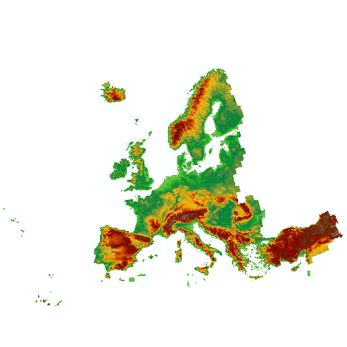
EU-DEM (raster) - version 1.1, Apr. 2016
The EU-DEM v1.1 is a resulting dataset of the EU-DEM v1.0 upgrade which enhances the correction of geo-positioning issues, reducing the number of artefacts, improving the vertical accuracy of EU-DEM using ICESat as reference and ensuring consistency with EU-Hydro public beta.
EU-DEM v1.1 is available in GeoTIFF 32 bits format. It is a contiguous dataset divided into 100x100 km tiles, resulting in a total of 1992 tiles of 4000x4000 pixel at 25m resolution with vertical accuracy: +/- 7 meters RMSE. The tiles have been grouped in big regions:
- EUDEM2_ASIA (Türkiye)
- EUDEM2_ATLAN (Hondo and Fr_Islands)
- EUDEM2_BRITAIN (Thames, Shannon and Tweed)
- EUDEM2_EUROPE_1 (Duero, Ebro, Tajo, Guadalquivir and Jucar)
- EUDEM2_EUROPE_2 (Tirso, Mesima, Tevere and Po)
- EUDEM2_EUROPE_3 (Garonne, Rhone, Loire, Seine and western Rhine)
- EUDEM2_EUROPE_4 (Danube)
- EUDEM2_EUROPE_5 (Skjern, Nemunas, Vistula, Oder, Elbe and Eastern Rhine)
- EUDEM2_EUROPE_6 (Bulgaria and Pinios)
- EUDEM2_ICELAND (Iceland)
- EUDEM2_SCAND (Vorma, Gota, Angerman, Tana, Kemi and Neva)
- EUDEM2_SOUTH_AMERICA (Fr_Guiana)
EU-DEM v1.1 upgrade was coordinated by the European Environment Agency (EEA) in the frame of the EU Copernicus programme.
Simple
Identification info
- Date (Creation)
- 2016-04-20
- Date (Publication)
- 2016-04-20
- Date (Revision)
- 2016-04-20
- Edition
-
01.01
- Citation identifier
- copernicus_r_3035_25_m_eu-dem_p_2011_v01_r01
- Citation identifier
- DAT-193-en
- Status
- Obsolete
- Point of contact
-
Organisation Individual Electronic mail address Website Role European Commission
Owner Copernicus Land Monitoring Service
Custodian European Environment Agency
Publisher Copernicus Land Monitoring Service helpdesk
Point of contact
- Spatial representation type
- Grid
Spatial resolution
- Spatial resolution
- 25 m
- Topic category
-
- Environment
- Imagery base maps earth cover
Extent
Temporal extent
- Time period
- 2011-01-01 2011-12-31
Extent
))
))
- Maintenance and update frequency
- Continual
Resource constraints
- Access constraints
- Other restrictions
- Other constraints
- no limitations to public access
Resource constraints
- Use constraints
- Other restrictions
- Other constraints
-
The Copernicus component is governed by Regulation (EU) No 2021/696 of the European Parliament and of the Council of 28 April 2021 establishing the Union Space Programme and the European Union Agency for the Space Programme and repealing Regulations (EU) No 912/2010, (EU) No 1285/2013 and (EU) No 377/2014 and Decision No 541/2014/EU. Within the Copernicus component, a portfolio of land monitoring activities has been delegated by the European Union to the European Environment Agency (EEA) and the DG Joint Research Centre of the European Commission.
The Copernicus land monitoring products and services are made available on a principle of full, open and free access, as established by the Commission Delegated Regulation (EU) No 1159/2013 of 12 July 2013.
Free, full and open access to the products and services of the Copernicus Land Monitoring Service is made on the conditions that:
1. When distributing or communicating Copernicus Land Monitoring Service products and services (data, software scripts, web services, user and methodological documentation and similar) to the public, users shall inform the public of the source of these products and services.
2. Where the Copernicus Land Monitoring Service products and services have been adapted or modified by the user, the user shall clearly state this.
3. Users shall make sure not to convey the impression to the public that the user's activities are officially endorsed by the European Union.
Associated resource
- Association Type
- Revision Of
- Metadata Reference
- Language
- English
- Character encoding
- UTF8
Distribution Information
- Distribution format
-
-
GeoTIFF
-
- Distributor contact
-
Organisation Individual Electronic mail address Website Role
- Ordering instructions
-
EU-DEM is not maintained anymore by the Copernicus Land Monitoring Service.
Copernicus DEM product publicly available at 30 m and 90 m spatial resolution can be accessed on the Copernicus Data Space Ecosystem (CDSE). More information can be found here: https://dataspace.copernicus.eu/explore-data/data-collections/copernicus-contributing-missions/collections-description/COP-DEM
If you have further questions please contact the CLMS helpdesk at JRC-Copernicus-Land@ec.europa.eu
Data quality info
- Hierarchy level
- Dataset
Report
Result
- Title
- Commission Regulation (EU) No 1089/2010 of 23 November 2010 implementing Directive 2007/2/EC of the European Parliament and of the Council as regards interoperability of spatial data sets and services
- Date (Publication)
- 2010-12-08
- Explanation
-
See the referenced specification
Resource lineage
- Statement
-
•Correction of geo-positioning issues in EU-DEM v1.0 as reference also using SPOT 2011 imagery
•Bias adjustment with ICESat points
•Screening and removal of artefacts in the EU-DEM v1.0, including the presence of blunders (i.e. negative or positive anomalies)
•Ensuring consistency with EU-Hydro to produce a better river network topology:
--Consistency of the coastline with the EU-HYDRO coastline, including the removal of DEM values outside the EU-HYDRO coastline
--Use of the EU-HYDRO coastline to smooth the gradient to the coast in flat regions
--Burning of EU-HYDRO water bodies to set EU-DEM to the minimum height inside the water body, smoothing the boundaries
- Hierarchy level
- Dataset
Reference System Information
Reference System Information
- Code
- EPSG:3035
- Maintenance and update frequency
Metadata
- Metadata identifier
- 3473589f-0854-4601-919e-2e7dd172ff50
- Language
- English
- Character encoding
- UTF8
- Contact
-
Organisation Individual Electronic mail address Website Role European Environment Agency
Point of contact
Type of resource
- Resource type
- Dataset
- Metadata linkage
-
https://sdi.eea.europa.eu/catalogue/srv/api/records/3473589f-0854-4601-919e-2e7dd172ff50
- Date info (Creation)
- 2018-01-22T09:56:54Z
- Date info (Revision)
- 2025-10-09T10:44:33.29722Z
Metadata standard
- Title
-
ISO 19115/19139
- Edition
-
1.0
),POLYGON((44.8212%2034.5619,44.8212%2071.1855,-10.6198%2071.1855,-10.6198%2034.5619,44.8212%2034.5619))))