 EEA geospatial data catalogue
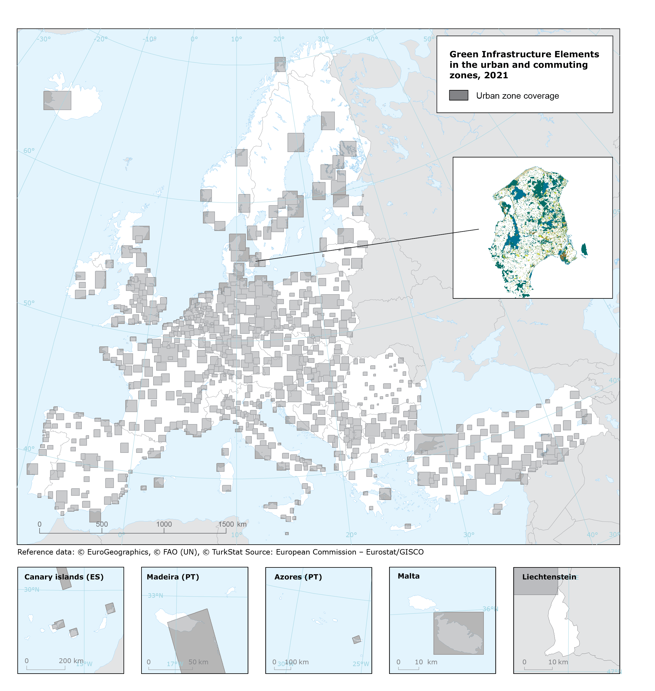
Green Infrastructure Elements in the urban and commuting zones in 2018 - version 1, May 2021
This metadata refers to the raster data on green infrastructure networks covering 786 cities in EEA38 member countries and United Kingdom in 2018. The dataset consist of strategically planned natural and man-made green structures, designed to deliver a wide range of ecosystem services. These services include water and air purification, space for recreation and climate mitigation and adaptation. This network of green (land) and blue (water) spaces can improve environmental conditions and therefore citizens' health and quality of life. It also supports a green economy, creates job opportunities and enhances biodiversity. To maximise its benefits, Green Infrastructure should be an essential component of spatial and physical planning.
Green Infrastructure comprises a wide range of environmental features that operate at different scales and form part of an interconnected ecological network. This dataset identifies the Green Infrastructure elements in the urban and commuting zones. These elements are green urban areas, private gardens, sports and leisure areas, allotments, trees, natural and semi-natural areas, high nature value agricultural areas, and blue elements (wetlands and water).
Simple
Identification info
- Date (Creation)
- 2021-09-30
- Date (Publication)
- 2021-09-30
- Edition
-
01.00
- Citation identifier
- eea_r_3035_10_m_green-urban-areas-elements_p_2018_v01_r00
- Spatial representation type
- Grid
Spatial resolution
- Spatial resolution
- 10 m
- Topic category
-
- Environment
- Biota
Extent
))
Temporal extent
- Time period
- 2018-01-01 2018-12-31
Extent
- Maintenance and update frequency
- As needed
- GEMET
-
-
environmental analysis
-
natural areas, landscape, ecosystems
-
urban ecology
-
urban environment, urban stress
-
animal corridor
-
forest ecology
-
animal habitat
-
natural areas protection
-
built environment
-
agriculture
-
- Continents, countries, sea regions of the world.
-
-
United Kingdom
-
EEA38 (from 2020)
-
- Spatial scope
-
-
European
-
- Temporal resolution
-
-
Annually
-
Resource constraints
- Access constraints
- Other restrictions
- Other constraints
- no limitations to public access
Resource constraints
- Use constraints
- Other restrictions
- Other constraints
-
License CC-BY 4.0 ( https://creativecommons.org/licenses/by/4.0/). Copyright holder: European Environment Agency (EEA).
As this dataset is also derived from Copernicus products, it also applies the Copernicus data and information policy: Access to data is based on a principle of full, open and free access as established by the Copernicus data and information policy Regulation (EU) No 1159/2013 of 12 July 2013. This regulation establishes registration and licensing conditions for GMES/Copernicus users. Free, full and open access to this data set is made on the conditions that:
1. When distributing or communicating Copernicus dedicated data and Copernicus service information to the public, users shall inform the public of the source of that data and information.
2. Users shall make sure not to convey the impression to the public that the user's activities are officially endorsed by the Union.
3. Where that data or information has been adapted or modified, the user shall clearly state this.
4. The data remain the sole property of the European Union. Any information and data produced in the framework of the action shall be the sole property of the European Union. Any communication and publication by the beneficiary shall acknowledge that the data were produced “with funding by the European Union”.
Additionally, this dataset is also derived from OpenStreetMap data and are licensed under the Open Database 1.0 License. See www.openstreetmap.org for details about the project.
- Language
- English
Distribution Information
Data quality info
- Hierarchy level
- Dataset
Report
Result
- Title
-
Commission Regulation (EU) No 1089/2010 of 23 November 2010 implementing Directive 2007/2/EC of the European Parliament and of the Council as regards interoperability of spatial data sets and services
- Date (Publication)
- 2010-12-08
- Explanation
-
See the referenced specification
Resource lineage
- Statement
-
The production of Green Infrastructure Elements in the urban and commuting zones for Functional Urban Area in Europe is mainly based on pan-European comparable land use / land cover cartography from Urban Atlas 2018 (Copernicus). It also makes use of ancillary data as follows:
CDDA - Nationally designated areas (CDDA_2020_v01_public_EuropeEPSG3035)
HNVF - High Nature Value Farmland (eea_r_3035_100_m_hnv-farmland-ac_p_2012_v01_r00)
IMD - Imperviousness Density 2018 (IMD_2018_010m_03035_v020)
STL - Street Tree Layer (UA2018_STL_v012)
SWF - Small Woody Features (SWF_2015_005m_3035_v012)
TCD - Tree Cover Density (TCD_2018_010m_al_03035_v020)
OSM - OpenStreet Map (downloaded the 2020-10-13 from http://download.geofabrik.de/europe)
Using Urban Atlas as a baseline, the different ancillary datasets are used to discriminate a range of Green Infrastructure Elements such as green urban areas from public spaces, private gardens, green areas from sports and leisure facilities, urban and periurban allotments, trees, natural and semi-natural areas, agricultural areas within High Nature Value Farmland, and blue elements (including wetlands and water).
Green urban areas from public spaces is mainly based on UA class 'green urban areas' (code = '14100') and complemented by those OSM tags 'leisure=park, leisure=common' (geofabrik code = 7202) with an imperviousness (IMD) density value minimum <= 20 and mean <= 45.
Private gardens are obtained from UA residential areas (discontinuous urban fabric: codes 11220, 11230, 11240; and isolated structures: 11300) after removing the impervious areas equal or higher than 25%.
Green areas from sports and leisure facilities follow the same approach but are based on UA (Value = 14200) after removing impervious areas (>=25%).
Urban and periurban allotments uses OSM tag 'landuse=allotments' (geofabrik code = 7207).
Trees is a composite of a rasterization of STL and the TCD where no other GI elements are identified.
Natural and semi-natural areas uses UA forests and herbaceous vegetation (Value = 31000 OR Value = 32000).
Agricultural areas within High Nature Value Farmland selects those agricultural areas from UA (2100, 22000, 23000, 24000 and 25000) that fall within the boundaries of High Value Nature Farmland.
Finally, blue elements include UA classes wetlands and water bodies (40000 and 50000).
- Hierarchy level
- Dataset
- Source
-
- Imperviousness Density 2018 (raster 10 m), Europe, 3-yearly, Aug. 2020
- Urban Atlas Street Tree Layer 2018 (vector), Europe, 6-yearly, Feb. 2021
- Nationally designated areas (CDDA) for public access - version 18, May 2020
- Small Woody Features 2015 (raster 5 m), Europe, 3-yearly - Nov. 2019
- High Nature Value (HNV) farmland 2012 (100 m) accounting version, Nov. 2017
- Tree Cover Density 2018 (raster 10 m), Europe, 3-yearly, Sep. 2020
Reference System Information
Reference System Information
- Code
- EPSG:3035
Metadata
- Metadata identifier
- 36778099-d630-498d-bc6e-3cd92edd99c1
- Language
- English
- Character encoding
- UTF8
- Contact
-
Organisation Individual Electronic mail address Website Role European Environment Agency
Point of contact
Type of resource
- Resource type
- Dataset
- Metadata linkage
-
https://sdi.eea.europa.eu/catalogue/srv/api/records/36778099-d630-498d-bc6e-3cd92edd99c1
- Date info (Creation)
- 2022-06-08T09:42:25.631Z
- Date info (Revision)
- 2025-10-09T10:44:55.273084Z
Metadata standard
- Title
-
ISO 19115/19139
- Edition
-
1.0
)))