 EEA geospatial data catalogue
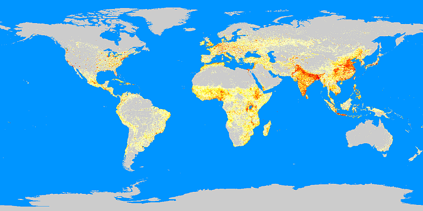
LandScan Global Population Database - version 15, Jul. 2014
Using an innovative approach with Geographic Information Systems and Remote Sensing, ORNL’s LandScan is the community standard for global population distribution. At 30 arc-second (approximately 1 km) resolution, LandScan is the finest resolution global population distribution data available and represents an “ambient population” (average over 24 hours). The LandScan algorithm, an R&D 100 Award Winner, uses spatial data and imagery analysis technologies and a multi-variable dasymetric modeling approach to disaggregate census counts within an administrative boundary. LandScan population data are spatially explicit - unlike tabular Census data. Since no single population distribution model can account for the differences in spatial data availability, quality, scale, and accuracy as well as the differences in cultural settlement practices, LandScan population distribution models are tailored to match the data conditions and geographical nature of each individual country and region.
Purpose: LandScan Global was developed for the U.S. Department of Defense and is used for rapid consequence and risk assessment as well as emergency planning and management.
Detailed information are to be found in cover_letter_ls13.pdf
Simple
Identification info
- Date (Creation)
- 2014-07-01
- Citation identifier
- ornl_g_4326_30_arcsec_landscan_2013_rev15
- Status
- Obsolete
- Spatial representation type
- Grid
Spatial resolution
- Spatial resolution
- 1 km
- Topic category
-
- Society
Extent
))
Extent
Temporal extent
- Time period
- 2013-07-01 2013-07-01
- Maintenance and update frequency
- Annually
- Theme
-
-
people
-
Population
-
Population count
-
- Place
-
-
Global
-
world-wide
-
Resource constraints
- Use limitation
-
License. Terms and conditions of use are available in the file License.pdf
Resource constraints
- Access constraints
- license
- Use constraints
- license
- Language
- English
- Character encoding
- UTF8
Distribution Information
- Distribution format
-
-
AIG
-
- OnLine resource
-
Direct download (Eionet authentication)
Data quality info
- Hierarchy level
- Dataset
Report
Result
- Title
- Commission Regulation (EU) No 1089/2010 of 23 November 2010 implementing Directive 2007/2/EC of the European Parliament and of the Council as regards interoperability of spatial data sets and services
- Date (Publication)
- 2010-12-08
- Explanation
-
See the referenced specification
Resource lineage
- Statement
-
Detailed information are to be found in cover_letter_ls13.pdf, IMPORTANT.pdf and in LSpopMetadata/lspop2013.htm.
- Hierarchy level
- Dataset
Reference System Information
Reference System Information
- Code
- EPSG:4326
Metadata
- Metadata identifier
- 39e6a1fb-5217-4e22-ab2e-68d50d11faeb
- Language
- English
- Character encoding
- UTF8
- Contact
-
Organisation Individual Electronic mail address Website Role European Environment Agency
Point of contact
Type of resource
- Resource type
- Dataset
- Metadata linkage
-
https://sdi.eea.europa.eu/catalogue/srv/api/records/39e6a1fb-5217-4e22-ab2e-68d50d11faeb
- Date info (Creation)
- 2016-08-23T07:26:39Z
- Date info (Revision)
- 2026-02-19T15:07:06.361452Z
Metadata standard
- Title
-
ISO 19115/19139
- Edition
-
1.0
)))