 EEA geospatial data catalogue
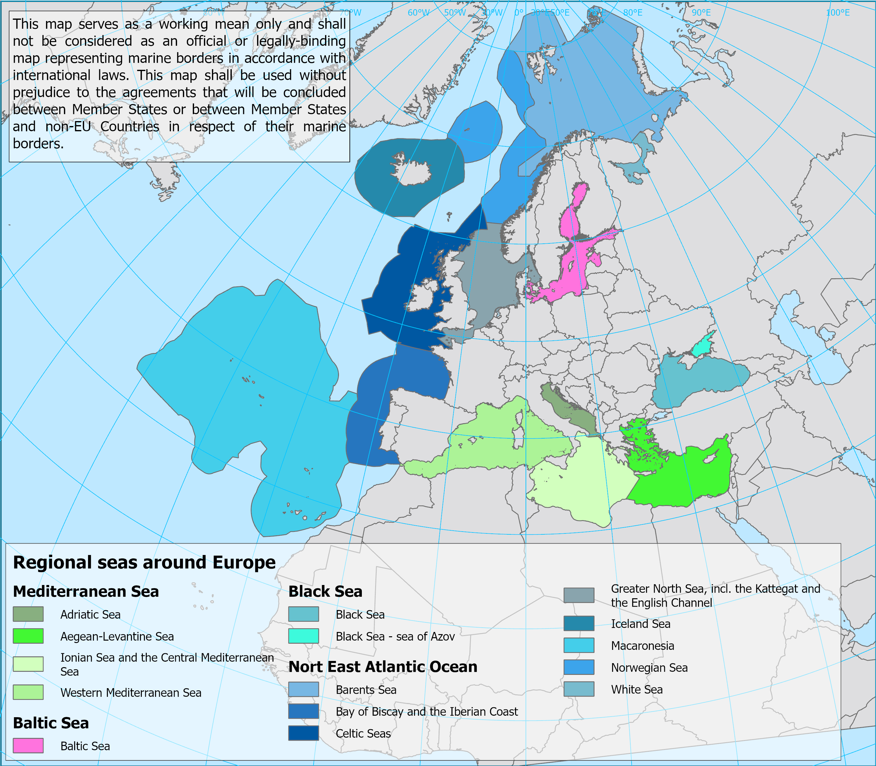
Regional seas around Europe - version 2, Oct. 2022
The regional seas around Europe are the Baltic Sea, the Black Sea, the North-east Atlantic Ocean and the Mediterranean Sea. Two of these regions are further divided into subregions:
North-east Atlantic Ocean
• the Barents Sea;
• the Iceland Sea;
• the Norwegian Sea;
• the White Sea;
• The Greater North Sea, including the Kattegat, and the English Channel;
• The Celtic Seas;
• The Bay of Biscay and the Iberian Coast;
• Macaronesia.
Mediterranean Sea:
• The Western Mediterranean Sea;
• The Adriatic Sea;
• The Ionian Sea and the Central Mediterranean Sea;
• The Aegean-Levantine Sea.
The regional seas are harmonised with the boundaries established as the MSFD regions and subregions, as agreed by the Marine Strategy Framework Directive Committee in November 2016. The delineation of additional seas follows the boundaries established under Regional Sea Conventions and ICES ecoregions.
The present map is provided in ESRI shape- and ESRI Geodatabase formats.
Simple
Identification info
- Date (Creation)
- 2022-09-28
- Date (Publication)
- 2022-10-14
- Edition
-
01.00
- Citation identifier
- eea_v_3035_100_k_regional-seas-europe_p_2021-now_v01_r00
- Point of contact
-
Organisation Individual Electronic mail address Website Role European Environment Agency
Point of contact
- Spatial representation type
- Vector
Spatial resolution
Equivalent scale
- Denominator
- 100000
- Topic category
-
- Environment
- Geoscientific information
- Oceans
- Boundaries
Extent
))
Temporal extent
- Time period
- 2021-01-01
- Maintenance and update frequency
- As needed
- Continents, countries, sea regions of the world.
-
-
White Sea
-
Aegean Sea
-
Baltic Sea
-
Iceland Sea
-
Mediterranean Sea
-
Northeast Atlantic Ocean (40W)
-
Barents Sea
-
Adriatic Sea
-
Ionian Sea
-
Black Sea
-
Bay of Biscay
-
- INSPIRE priority data set
-
-
Marine regions (Marine Strategy Framework Directive)
-
Marine sub-regions (Marine Strategy Framework Directive)
-
Directive 2008/56/EC
-
Resource constraints
- Access constraints
- Other restrictions
- Other constraints
-
The map should not be understood as representing international marine borders. To this end, the following disclaimer will accompany the map: "This map serves as a working tool only and shall not be considered as an official or legally-binding map representing marine borders in accordance with international laws. This map shall be used without prejudice to the agreements that will be concluded between Member States or between Member States and non-EU states in respect of their marine borders.". No limitations to public access License CC-BY 4.0 ( https://creativecommons.org/licenses/by/4.0/). Copyright holder: European Environment Agency (EEA).
- Other constraints
- no limitations to public access
Resource constraints
- Use constraints
- Other restrictions
- Other constraints
-
License CC-BY 4.0 ( https://creativecommons.org/licenses/by/4.0/). Copyright holder: European Environment Agency (EEA).
- Language
- English
- Character encoding
- UTF8
Distribution Information
- Distribution format
-
-
GDB
-
SHP
-
- OnLine resource
-
Direct download
Data quality info
- Hierarchy level
- Dataset
Report
Result
- Title
- Commission Regulation (EU) No 1089/2010 of 23 November 2010 implementing Directive 2007/2/EC of the European Parliament and of the Council as regards interoperability of spatial data sets and services
- Date (Publication)
- 2010-12-08
- Explanation
-
See the referenced specification
Resource lineage
- Statement
-
The present map provides the spatial extent of the regional seas around Europe. The dataset includes information on the MSFD regions and subregions, as agreed by the MSFD Committee in November 2016.
In the Marine Strategy Framework Directive - MSFD (Directive 2008/56/EC of the European Parliament and of the Council of 17 June 2008 establishing a framework for community action in the field of marine environmental policy), four marine regions are listed (Article 4): Baltic Sea, North-east Atlantic Ocean, Mediterranean Sea and the Black Sea, among which the following two are further divided into four subregions each:
In the context of MSFD, the North-east Atlantic Ocean includes:
o The Greater North Sea, including the Kattegat and the English Channel;
o The Celtic Seas;
o The Bay of Biscay and the Iberian Coast;
o Macaronesia.
In the context of MSFD, the Iceland Sea, the Norwegian Sea, and the high seas are not included.
In the context of MSFD, the Mediterranean Sea includes:
o The Western Mediterranean Sea;
o The Adriatic Sea;
o The Ionian Sea and the Central Mediterranean Sea;
o The Aegean-Levantine Sea.
The delineation of the marine regions and subregions under the MSFD was developed over the period 2010-2016 through the MSFD Common Implementation Strategy, supported by the EEA and the ETC-ICM. The map was adopted by EU Member States in the MSFD Committee in November 2016. The basis for the boundaries between the marine regions and subregions is described in an EEA report (Jensen, H.M, Panagiotidis, P. & Reker, J. 2017. Delineation of the MSFD Article 4 marine regions and subregions. Version 1.0 EEA, Copenhagen). The ICES ecoregions are being aligned with the MSFD region and subregion boundaries.
The landward boundary of all regions and subregions has used the “EEA coastline for analysis” (see https://www.eea.europa.eu/data-and-maps/data/eea-coastline-for-analysis-2); this is a practical solution because the MSFD landward boundary formally follows that defined for coastal waters under the Water Framework Directive, for which a consistent boundary is not yet available for all reporting countries.
Therefore, since it includes the delineation of marine regions and subregions agreed under the MSFD, the present map should take into account the following:
a. The marine regions and subregions defined under the MSFD are intended for the sole purpose of supporting the implementation of the MSFD by Member States, stakeholders and the European Commission and its agencies.
b. The present map provides boundaries of the marine regions and subregions as listed in MSFD Article 4, together with the delineation of other relevant seas surrounding Europe.
c. The map is not intended to provide boundaries of the marine waters of Member States. This means that the map does not represent the geographic scope of application of the MSFD as the MSFD only applies to Member States' marine waters, which are understood to lie within the marine regions and subregions. Further, in those areas of Member States' marine waters, the map makes no distinction between the jurisdiction over both the water column and the seabed or only the seabed.
d. As such the map should not be understood as representing international marine borders. To this end, the following disclaimer will accompany the map: "This map serves as a working tool only and shall not be considered as an official or legally-binding map representing marine borders in accordance with international laws. This map shall be used without prejudice to the agreements that will be concluded between Member States or between Member States and non-EU states in respect of their marine borders.".
e. As they are not intended to provide boundaries of Member States' marine waters, the landward boundaries used do not constitute the formal boundary of these marine waters, but instead use a harmonised coastline boundary for cartographic consistency.
f. In the North-east Atlantic Ocean region, the outer boundary of the Celtic Seas, Bay of Biscay and the Iberian Coast and Macaronesia subregions is intended to fully encompass the marine waters of the relevant EU Member States. This includes the Continental Shelf areas where these extend beyond Exclusive Economic Zones. For the North-east Atlantic Ocean region, the boundaries shown in the present map include those Continental Shelf areas which have so far been reported by the Member States concerned. As and when Member States report modifications to the boundaries of their marine waters, such as further Continental Shelf areas following conclusions under UNCLOS processes, the map should be updated.
g. Notwithstanding the need to update the map on the basis of point (f), the boundaries of the MSFD marine regions and subregions should be periodically reviewed to ensure they serve the purposes of the MSFD, and in particular an ecosystem-based approach to management of the marine environment. Such review should be undertaken in advance of the periodic updates of Article 8 and take into account the latest scientific evidence on the characteristics of the marine ecosystems, as reflected in MSFD Art. 3(2).
This map is an updated version of one of the layers in "Europe Seas - version 1, Dec. 2018" map, with the following updates:
- Wider Atlantic region delineated by the Convention for the Protection of the Marine Environment of the North-East Atlantic (the ‘Oslo-Paris Convention') and previously representing North-east Atlantic Ocean region has been removed from the map.
- The Sea of Azov does not fall within the geographic scope of application of the Bucharest Convention. Therefore, it has a different Id than the Black Sea region, even though it is part of the MSFD Black Sea region.
- The Sea of Marmara, designated by national authorities as an inland water body located entirely within the borders of Turkey, is not included in this map .
- The outward boundary of Macaronesia has been updated in order to fully encompass the latest marine waters reported by Portugal
-The extended continental shelf area of Rockall/Hatton Bank have been excluded from the map.
- Hierarchy level
- Dataset
Reference System Information
Reference System Information
- Code
- EPSG:3035
Metadata
- Metadata identifier
- 51035cd2-3dea-4b39-94c7-e53946603c2a
- Language
- English
- Character encoding
- UTF8
- Contact
-
Organisation Individual Electronic mail address Website Role European Environment Agency
Point of contact
Type of resource
- Resource type
- Dataset
- Metadata linkage
-
https://sdi.eea.europa.eu/catalogue/srv/api/records/51035cd2-3dea-4b39-94c7-e53946603c2a
- Date info (Creation)
- 2022-06-22T07:24:49.619Z
- Date info (Revision)
- 2025-11-05T15:34:48.187102Z
Metadata standard
- Title
-
ISO 19115/19139
- Edition
-
1.0
)))