 EEA geospatial data catalogue
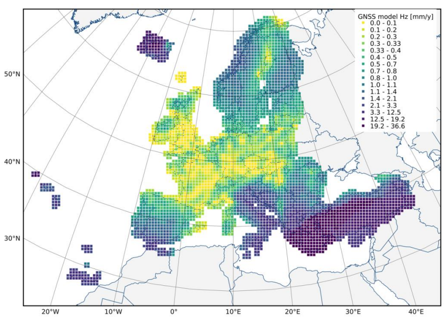
European Ground Motion Service: GNSS model 2015-2020 (vector), Europe, 2-yearly, Jul. 2022
The European Ground Motion Service (EGMS) is a component of the Copernicus Land Monitoring Service. EGMS provides consistent, regular, standardised, harmonised and reliable information regarding natural and anthropogenic ground motion phenomena over the Copernicus Participating States and across national borders, with millimetre accuracy.
This layer is produced based on GNSS data from various sources, with the EUREF Densification network as the main entry point. After filtering and quality control, a total of 3770 stations are used to generate the GNSS model which contains average velocities in east, north and up directions displayed on a 50-km grid. The grid dimension is determined by the average distance between well-maintained GNSS stations over continental Europe.
The GNSS model is distributed to users in a single comma-separated values file. Each cell of the model is associated to a value of vertical and horizontal velocity. The product covers the Copernicus Participating States (except for DROMs) and United Kingdom.
Simple
Identification info
- Date (Creation)
- 2021-10-05
- Date (Publication)
- 2022-07-15
- Edition
-
01.00
- Citation identifier
- copernicus_v_3035_50_km_egms-gnss-model_p_2015-2020_v01_r00
Identifier
- Point of contact
-
Organisation Individual Electronic mail address Website Role European Commission
Owner Copernicus Land Monitoring Service
Custodian European Environment Agency
Publisher Copernicus Land Monitoring Service helpdesk
Point of contact
- Spatial representation type
- Vector
Spatial resolution
- Spatial resolution
- 50 km
- Topic category
-
- Geoscientific information
Extent
))
Temporal extent
- Time period
- 2015-02-01 2020-12-31
- Maintenance and update frequency
- Annually
- GEMET - INSPIRE themes, version 1.0
-
-
Natural risk zones
-
- Continents, countries, sea regions of the world.
-
-
EEA38 (from 2020)
-
United Kingdom
-
- GEMET
-
-
calibration
-
geodesy
-
earth observation
-
model
-
geo-referenced information
-
- Temporal resolution
-
-
Not planned
-
Resource constraints
- Access constraints
- Other restrictions
- Other constraints
- no limitations to public access
Resource constraints
- Use constraints
- Other restrictions
- Other constraints
-
The Copernicus component is governed by Regulation (EU) No 2021/696 of the European Parliament and of the Council of 28 April 2021 establishing the Union Space Programme and the European Union Agency for the Space Programme and repealing Regulations (EU) No 912/2010, (EU) No 1285/2013 and (EU) No 377/2014 and Decision No 541/2014/EU. Within the Copernicus component, a portfolio of land monitoring activities has been delegated by the European Union to the European Environment Agency (EEA) and the DG Joint Research Centre of the European Commission.
The Copernicus land monitoring products and services are made available on a principle of full, open and free access, as established by the Commission Delegated Regulation (EU) No 1159/2013 of 12 July 2013.
Free, full and open access to the products and services of the Copernicus Land Monitoring Service is made on the conditions that:
1. When distributing or communicating Copernicus Land Monitoring Service products and services (data, software scripts, web services, user and methodological documentation and similar) to the public, users shall inform the public of the source of these products and services.
2. Where the Copernicus Land Monitoring Service products and services have been adapted or modified by the user, the user shall clearly state this.
3. Users shall make sure not to convey the impression to the public that the user's activities are officially endorsed by the European Union.
Associated resource
- Association Type
- Cross reference
- Language
- English
- Character encoding
- UTF8
Distribution Information
Data quality info
- Hierarchy level
- Dataset
Report
Result
- Title
- Commission Regulation (EU) No 1089/2010 of 23 November 2010 implementing Directive 2007/2/EC of the European Parliament and of the Council as regards interoperability of spatial data sets and services
- Date (Publication)
- 2010-12-08
- Explanation
-
See the referenced specification
Resource lineage
- Statement
-
The GNSS model is obtained from the analysis of 3770 GNSS stations mainly part of the EUREF Densification network. The stations were selected based on the following criteria:
i) minimum length of time series >3 years,
ii) stations should not record time series with artificial artifacts and
iii) stations should not record strong non-linear motion except for seasonality.
The GNSS model is then derived following the least-squares collocation concept. The principle behind this approach is to use the correlations of GNSS station velocities to predict new values at any new point within the covered area, together with associated uncertainties.
- Hierarchy level
- Dataset
Reference System Information
Reference System Information
- Code
- EPSG:3035
- Maintenance and update frequency
Metadata
- Metadata identifier
- 538ebcde-a5cb-4911-ab61-f97b661a3193
- Language
- English
- Character encoding
- UTF8
- Contact
-
Organisation Individual Electronic mail address Website Role European Environment Agency
Point of contact
Type of resource
- Resource type
- Dataset
- Metadata linkage
-
https://sdi.eea.europa.eu/catalogue/srv/api/records/538ebcde-a5cb-4911-ab61-f97b661a3193
- Date info (Creation)
- 2021-12-09T09:42:37.18Z
- Date info (Revision)
- 2025-10-09T10:50:38.649121Z
Metadata standard
- Title
-
ISO 19115/19139
- Edition
-
1.0
)))